1960s Maps of Ketchikan Gateway, Alaska
Explore 2 historic maps of Ketchikan Gateway from the 1960s. These maps offer a rare glimpse into what life looked like during the 1960s — showing old roads, neighborhoods, homes, and landmarks that have changed or disappeared over time.
Whether you're researching your family's past, planning a metal detecting trip, or studying how Ketchikan Gateway's landscape evolved across the 1960s, these high-resolution maps are a powerful tool for exploring the history of this region.
- Focus on a specific era: All maps on this page are from the 1960s, giving you a focused view of this time period.
- See what’s changed: Compare century-old streets, trails, and buildings to today's modern landscape using overlays and satellite layers.
- Research with precision: Use these maps for genealogy, historical research, land use analysis, or educational projects.
- View, download, or print: Maps are fully viewable online in high resolution, and can be downloaded or printed for your own records.
Start exploring Ketchikan Gateway's history through authentic maps from the 1960s. This is your window into the past.
Ketchikan Gateway, AK maps
(2)- 1962 Map of Ketchikan D-4, 1963 Print
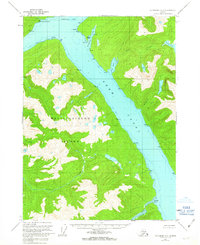 1962 Ketchikan D-41963 Print · USGSThe Alaskan wilderness of the early sixties is revealed through the intricate coastlines of Revillagigedo Island and the Behm Canal. Researchers can trace the waterways of Fitzgibbon Cove and Saks Lake or locate the survey markers at Burroughs Bay South Base.
 - 1964 Map of Prince Rupert
 1964 Prince Rupert1964 Print · USGSThe maritime boundary between Alaska and British Columbia comes alive in the mid-1960s, showing the vital port of Prince Rupert and its surrounding coastal islands. Genealogists and historians can trace rail-to-sea connections at Port Edward, the Canadian National line, and settlements like Metlakatla or Georgetown Mills.
End of results
Showing maps 1-2 of 2
Top cities of Ketchikan Gateway
Frequently asked questions
- What are the different types of historical maps available for Ketchikan Gateway?
- What is the oldest map of Ketchikan Gateway?
- Where can I purchase historical maps of Ketchikan Gateway for my home or office?
- Where can I download high-res historical maps of Ketchikan Gateway?
- Are there historical topographic maps available for Ketchikan Gateway?
- Is there historical aerial imagery available for Ketchikan Gateway?
- Where are historical maps of Ketchikan Gateway sourced from?