1990s Maps of Ketchikan Gateway, Alaska
Explore 17 historic maps of Ketchikan Gateway from the 1990s. These maps offer a rare glimpse into what life looked like during the 1990s — showing old roads, neighborhoods, homes, and landmarks that have changed or disappeared over time.
Whether you're researching your family's past, planning a metal detecting trip, or studying how Ketchikan Gateway's landscape evolved across the 1990s, these high-resolution maps are a powerful tool for exploring the history of this region.
- Focus on a specific era: All maps on this page are from the 1990s, giving you a focused view of this time period.
- See what’s changed: Compare century-old streets, trails, and buildings to today's modern landscape using overlays and satellite layers.
- Research with precision: Use these maps for genealogy, historical research, land use analysis, or educational projects.
- View, download, or print: Maps are fully viewable online in high resolution, and can be downloaded or printed for your own records.
Start exploring Ketchikan Gateway's history through authentic maps from the 1990s. This is your window into the past.
Ketchikan Gateway, AK maps
(17)- 1991 Map of Ketchikan B-5 SW
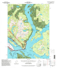
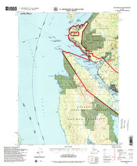
 1991 Ketchikan B-5 SW1991 Print · USGSThe maritime gateway of Ketchikan and the neighboring community of Saxman are captured here during the 1990s. Researchers can trace the waterfront infrastructure of Ketchikan Harbor and historic locations like China Town on Annette Island.2 unique versions available
 - 1991 Map of Ketchikan B-5 NW
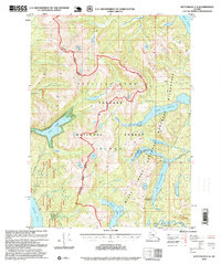
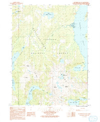 1991 Ketchikan B-5 NW1991 Print · USGSRevillagigedo Island in the early nineties remains a wilderness of interconnected lakes and mountain peaks. Hikers and historians can trace the topography around Mahoney Mine, find the Boardwalk near Lake Perseverance, and locate Harriet Hunt Lake.
 - 1991 Map of Ketchikan B-6 NE
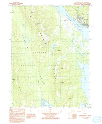
 1991 Ketchikan B-6 NE1991 Print · USGSSoutheast Alaska’s maritime and industrial landscape is captured here in the early nineties, centered on the western shore of Revillagigedo Island. Researchers can trace coastal history through the U S Coast Guard Station, Ward Cannery, and the Totem Bight State Historical Park.
 - 1991 Map of Ketchikan B-6 SE
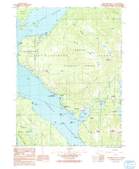
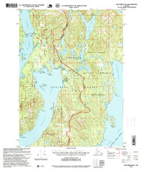
 1991 Ketchikan B-6 SE1991 Print · USGSKetchikan and its neighboring islands are captured in the early 1990s, showing the town's growth along the Tongass Narrows. Trace the unique ferry-access connection between the city and Ketchikan International Airport or explore named peaks like Dall Ridge and Nipple Mountain.
 - 1994 Map of Ketchikan B-5, 1998 Print
 1994 Ketchikan B-51998 Print · USGSThe Ketchikan waterfront and neighboring Saxman are captured here in the mid-nineties, showing a coastline defined by maritime industry and indigenous heritage. Researchers can trace the development of China Town on Annette Island or locate the site of the Mahoney Mine.
 - 1994 Map of Ketchikan B-6, 1998 Print
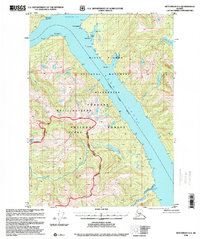
 1994 Ketchikan B-61998 Print · USGSSoutheast Alaska in the 1990s reveals a landscape defined by the maritime economy and the North Tongass Highway corridor. Genealogists and historians can trace coastal development through the US Coast Guard Station, Higgins Elm Sch, and industrial landmarks at Ward Cove.
 - 1995 Map of Ketchikan C-4, 1999 Print
 1995 Ketchikan C-41999 Print · USGSThe heart of Revillagigedo Island and the Misty Fiords are captured here during the mid-nineties. Researchers can locate remote Forest Service outposts like Manzanita Lake Cabin (FS) or trace the glacial waters of Lake Grace and Mirror Lake.
 - 1995 Map of Ketchikan B-4, 1999 Print
 1995 Ketchikan B-41999 Print · USGSRevillagigedo Island in the mid-nineties shows the essential maritime and forest infrastructure of the Ketchikan Gateway. You can trace the coastal logging economy through the Logging Camp and Log Transfer Facility, or locate remote outposts like the Sealevel Mine and the Loran Radio Sta (USCG).
 - 1995 Map of Bradfield Canal A-4, 1999 Print
 1995 Bradfield Canal A-41999 Print · USGSCoastal Alaska in the mid-nineties shows a landscape of deep fjords and river valleys where the Tongass National Forest meets the sea. Researchers can trace isolated outposts like Bishop Ranch and Matney Ranch along the banks of the Unuk River.
 - 1995 Map of Ketchikan C-6, 1999 Print
 1995 Ketchikan C-61999 Print · USGSSoutheast Alaska’s maritime wilderness comes into focus in the mid-nineties, showing a landscape shaped by mining history and forest management. Researchers can trace early industrial footprints at the Gold Standard Mine or locate remote sites like Indian Graves and the Helm Bay Cabin (FS).
 - 1996 Map of Ketchikan C-2, 2000 Print
 1996 Ketchikan C-22000 Print · USGSThe Alaskan wilderness of the mid-nineties is shown here as a roadless expanse of glaciated peaks and protected forest. Researchers can locate remote outposts like the Wilson View Cabin (FS) and trace the drainages of Wilson Lake and Walker Lake.
 - 1996 Map of Ketchikan D-4, 2000 Print
 1996 Ketchikan D-42000 Print · USGSSoutheast Alaska in the late nineties is a landscape of maritime wilderness and deep glacial carvings. Trace the intricate coastline of Revillagigedo Island and identify remote landmarks like Fitzgibbon Cove, Portage Cove, and Dew Point.
 - 1996 Map of Bradfield Canal A-1, 2000 Print
 1996 Bradfield Canal A-12000 Print · USGSThe international borderlands of Southeast Alaska meet British Columbia in this late twentieth-century revision, showcasing a landscape of glaciers and old mining infrastructure. Researchers can locate the Riverside Mine, an Aerial Tramway, and the Boundary Roadhouse.
 - 1996 Map of Ketchikan D-3, 2000 Print
 1996 Ketchikan D-32000 Print · USGSBehm Canal and the Southeast Alaska panhandle are documented in this late-nineties revision, highlighting a landscape defined by tidewater reaches and glacial rivers. Researchers can trace remote coastal points and inland waters like Chickamin River, Walker Cove, and Saks Lake.
 - 1996 Map of Ketchikan D-2, 2000 Print
 1996 Ketchikan D-22000 Print · USGSAlaskan wilderness near the Canadian border is mapped here during the late twentieth century, showing a landscape of ice and water. Trace the path of the Through Glacier or the winding Chickamin River through the heart of the Tongass National Forest.
 - 1996 Map of Ketchikan C-3, 2000 Print
 1996 Ketchikan C-32000 Print · USGSBehm Canal and the deep glacial fjords of the Alaska Panhandle appear here in detail during the late nineties. Maritime history enthusiasts and researchers can trace the shores of Revillagigedo Island to find Soda Springs, the Gaging Station, and the prominent New Eddystone Rock.
 - 1997 Map of Bradfield Canal A-1, 2000 Print
 1997 Bradfield Canal A-12000 Print · USGSIn the late nineties, this coastal corner of the Tongass National Forest supported a network of remote wilderness outposts and hydroelectric infrastructure. You can trace early habitations at Cabin Ruins and locate active Forest Service sites like Reflection Lake Shelter (FS) and the Powerhouse near Tyee Lake.
End of results
Showing maps 1-17 of 17
Top cities of Ketchikan Gateway
Frequently asked questions
- What are the different types of historical maps available for Ketchikan Gateway?
- What is the oldest map of Ketchikan Gateway?
- Where can I purchase historical maps of Ketchikan Gateway for my home or office?
- Where can I download high-res historical maps of Ketchikan Gateway?
- Are there historical topographic maps available for Ketchikan Gateway?
- Is there historical aerial imagery available for Ketchikan Gateway?
- Where are historical maps of Ketchikan Gateway sourced from?