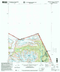
1996 Map of Bradfield Canal A-1
USGS Topo · Published 2000About this map
Tongass National Forest and the Misty Fiords National Monument dominate this landscape along the international boundary between Alaska and British Columbia. The survey captures the industrial remnants of the Salmon River valley, where the Riverside Mine and an associated Aerial Tramway reflect the area's mining history. Near the border, the Boundary Roadhouse marks a former stop for travelers moving between the coast and the interior. The physical geography is defined by high peaks like Mount Jefferson-Coolidge and Mount Bayard, which overlook a complex system of ice and water including the Texas Glacier and Texas Lake. Unique hydrologic features such as Disappearing Lake and the confluence of Ninemile Creek illustrate the dynamic glacial environment of this wilderness region.
Find a feature on this map
37 named features on this map. Tap any name to fly to it.
Don’t see what you’re looking for? This feature index may not catch every label — zoom into the map to look around manually.
Map Details
Editions of this 1996 Bradfield Canal A-1 Map
This is the sole edition of this map. No revisions or reprints were ever made.
Other maps of this area

1951 · Bradfield Canal
USGS Topo · 1:250,000

1952 · Ketchikan
USGS Topo · 1:250,000

1954 · Bradfield Canal
USGS Topo · 1:250,000

1955 · Bradfield canal B-2
USGS Topo · 1:63,360

1955 · Ketchikan D-2
USGS Topo · 1:63,360

1955 · Bradfield canal A-2
USGS Topo · 1:63,360

1955 · Bradfield Canal A-1
USGS Topo · 1:63,360

1955 · Ketchikan D-1
USGS Topo · 1:63,360

1955 · Ketchikan
USGS Topo · 1:250,000

1955 · Bradfield Canal
USGS Topo · 1:250,000