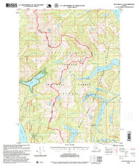
1995 Map of Ketchikan C-4
USGS Topo · Published 1999About this map
Revillagigedo Island dominates this mid-1990s survey, showing a landscape defined by deep water inlets and high alpine peaks within the Tongass National Forest. The map details the remote infrastructure of the Misty Fiords National Monument Wilderness, where backcountry access is centered around isolated outposts like the Manzanita Lake Cabin (FS) and Beaver Camp Cabin (FS).
Find a feature on this map
23 named features on this map. Tap any name to fly to it.
Don’t see what you’re looking for? This feature index may not catch every label — zoom into the map to look around manually.
Map Details
Editions of this 1995 Ketchikan C-4 Map
This is the sole edition of this map. No revisions or reprints were ever made.
Other maps of this area

1948 · Ketchikan C-5
USGS Topo · 1:63,360

1949 · Ketchikan B-4
USGS Topo · 1:63,360

1952 · Ketchikan
USGS Topo · 1:250,000

1952 · Ketchikan B-4
USGS Topo · 1:63,360

1952 · Ketchikan C-4
USGS Topo · 1:63,360

1952 · Ketchikan D-5
USGS Topo · 1:63,360

1953 · Ketchikan C-5
USGS Topo · 1:63,360

1953 · Ketchikan D-5
USGS Topo · 1:63,360

1954 · Ketchikan B-5
USGS Topo · 1:63,360

1955 · Ketchikan C-3
USGS Topo · 1:63,360