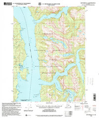
1996 Map of Ketchikan C-3
USGS Topo · Published 2000About this map
Behm Canal defines the central waterway of this coastal region, separating the massive Revillagigedo Island from the mainland. The landscape is dominated by the Misty Fiords National Monument Wilderness, where deep glacial inlets like Walker Cove and Rudyerd Bay cut into the granite peaks of the Tongass National Forest. Evidence of the area's volcanic history and geothermal activity is marked by Soda Springs on the western shore and the distinctive New Eddystone Rock rising from the canal floor. For researchers, the map identifies isolated infrastructure including a Gaging Station and Radio Repeater, alongside numerous named coastal points like Tramp Point and Point Louise that once served as navigational landmarks for the timber and fishing maritime traffic typical of the late 20th century.
Find a feature on this map
36 named features on this map. Tap any name to fly to it.
Don’t see what you’re looking for? This feature index may not catch every label — zoom into the map to look around manually.
Map Details
Editions of this 1996 Ketchikan C-3 Map
This is the sole edition of this map. No revisions or reprints were ever made.
Other maps of this area

1949 · Ketchikan B-4
USGS Topo · 1:63,360

1952 · Ketchikan
USGS Topo · 1:250,000

1952 · Ketchikan B-4
USGS Topo · 1:63,360

1952 · Ketchikan C-4
USGS Topo · 1:63,360

1955 · Ketchikan C-3
USGS Topo · 1:63,360

1955 · Ketchikan D-2
USGS Topo · 1:63,360

1955 · Ketchikan C-2
USGS Topo · 1:63,360

1955 · Ketchikan D-4
USGS Topo · 1:63,360

1955 · Ketchikan B-2
USGS Topo · 1:63,360

1955 · Ketchikan D-3
USGS Topo · 1:63,360