2020s Maps of Ketchikan Gateway, Alaska
Explore 143 historic maps of Ketchikan Gateway from the 2020s. These maps offer a rare glimpse into what life looked like during the 2020s — showing old roads, neighborhoods, homes, and landmarks that have changed or disappeared over time.
Whether you're researching your family's past, planning a metal detecting trip, or studying how Ketchikan Gateway's landscape evolved across the 2020s, these high-resolution maps are a powerful tool for exploring the history of this region.
- Focus on a specific era: All maps on this page are from the 2020s, giving you a focused view of this time period.
- See what’s changed: Compare century-old streets, trails, and buildings to today's modern landscape using overlays and satellite layers.
- Research with precision: Use these maps for genealogy, historical research, land use analysis, or educational projects.
- View, download, or print: Maps are fully viewable online in high resolution, and can be downloaded or printed for your own records.
Start exploring Ketchikan Gateway's history through authentic maps from the 2020s. This is your window into the past.
Ketchikan Gateway, AK maps
(143)- 2020 Map of Prince Rupert D-4 NE, 2020 Print
 2020 Prince Rupert D-4 NE2020 Print · USGSCovers Ketchikan Gateway, including United States, Alaska, and other nearby areas
 - 2021 Map of Ketchikan D-4 SE, 2021 Print
 2021 Ketchikan D-4 SE2021 Print · USGSCoastal wilderness in the Alexander Archipelago is mapped during the early 2020s, showing the intersection of timbered heights and the sea. Researchers can trace the rugged shoreline of Portage Cove and the vast boundaries of the Tongass National Forest.
 - 2021 Map of Ketchikan D-5 SE, 2021 Print
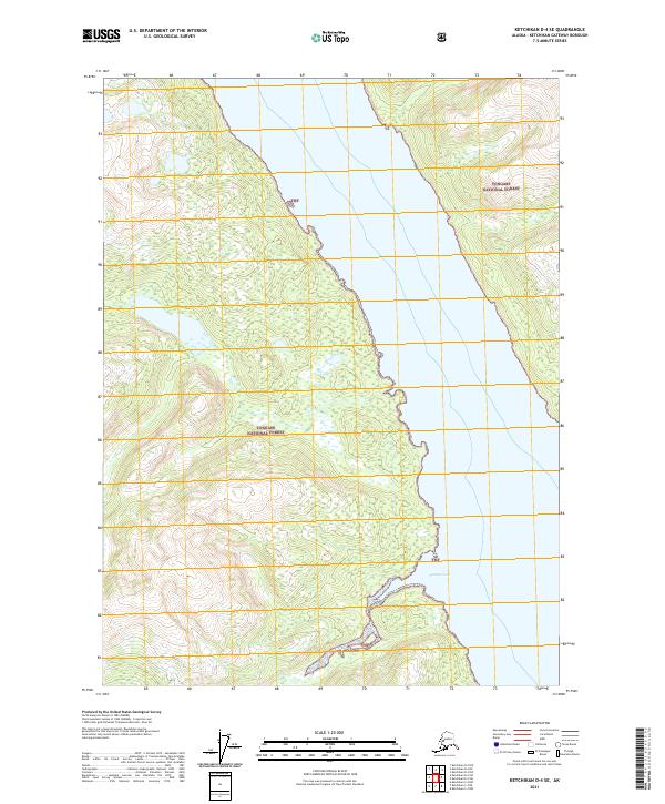
 2021 Ketchikan D-5 SE2021 Print · USGSRevillagigedo Island in the early twenty-first century showcases the intersection of the Tongass National Forest and the Behm Canal. Researchers can trace the coastal inlets of Shrimp Bay and inland waters like Orchard Lake.
 - 2021 Map of Ketchikan D-5 NE, 2021 Print
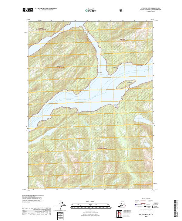 2021 Ketchikan D-5 NE2021 Print · USGSThe maritime reaches of the Ketchikan Gateway Borough are mapped here as they appeared in 2021. Navigators and researchers can trace the intricate shorelines of Bell Island and locate remote inland water bodies like Long Lake and Claude Lake.
 - 2021 Map of Ketchikan D-6 SW, 2021 Print
 2021 Ketchikan D-6 SW2021 Print · USGSSoutheast Alaska’s coastal wilderness is documented here as it appeared in the 2020s, showing the remote intersection of two boroughs. Trace the remote drainages of Wasta Cr and Hofstad Cr as they flow through the Tongass National Forest.
 - 2021 Map of Bradfield Canal A-3 NW, 2021 Print
 2021 Bradfield Canal A-3 NW2021 Print · USGSThe wilderness of Southeast Alaska is documented here as it appeared in the early 2020s. Researchers can trace the braided path of the Unuk River and locate remote water features like Sawmill Slough and Lake Creek within the Tongass National Forest.
 - 2021 Map of Bradfield Canal A-3 NE, 2021 Print
 2021 Bradfield Canal A-3 NE2021 Print · USGSThe wilderness of the Ketchikan Gateway Borough is shown here in the 2020s, dominated by the peaks of the Coast Mountains. Genealogists and historians can trace the course of Lake Cr through the vast Tongass National Forest.
 - 2021 Map of Bradfield Canal B-3 SE, 2021 Print
 2021 Bradfield Canal B-3 SE2021 Print · USGSThe international boundary through the Coast Mountains is captured here in the early twenty-first century. Modern topographies show how the Unuk River winds through the Tongass National Forest past Mt Stoeckl and First Canyon.
 - 2021 Map of Bradfield Canal A-3 SE, 2021 Print
 2021 Bradfield Canal A-3 SE2021 Print · USGSThe remote Alaskan wilderness near the Canadian border is captured in this recent survey of the Prince of Wales-Hyder Census Area. Researchers can trace the path of the glacial Leduc River and Klahini River as they thread through the Tongass National Forest.
 - 2021 Map of Bradfield Canal B-3 SW, 2021 Print
 2021 Bradfield Canal B-3 SW2021 Print · USGSIn the southeastern panhandle during the early twenty-first century, this survey tracks the complex glacial hydrology of the Tongass National Forest. Researchers can trace the path of the Blue River from Blue Lake down to its confluence with the Unuk River.
 - 2021 Map of Ketchikan D-6 NE, 2021 Print
 2021 Ketchikan D-6 NE2021 Print · USGSSoutheast Alaska's coastal wilderness is documented in this 2021 survey, centered on the dramatic intersection of forest and fjord. Researchers can trace the shoreline from Yes Bay to Lake McDonald, identifying maritime landmarks like Bluff Point and Black Island.
 - 2021 Map of Bradfield Canal A-1 SW, 2021 Print
 2021 Bradfield Canal A-1 SW2021 Print · USGSThe international boundary meets the massive ice fields of the Coast Mountains in this recent survey of the Alaska wilderness. Researchers can trace the glaciated drainages of Texas Glacier, Texas Lake, and the high peaks of Mt Jefferson Coolidge.
 - 2021 Map of Bradfield Canal A-2 NW, 2021 Print
 2021 Bradfield Canal A-2 NW2021 Print · USGSThe high wilderness of the Coast Mountains is documented here at the international border within the Tongass National Forest. Researchers can trace the path of the Leduc River and the reach of the Grassy Creek Glacier.
 - 2021 Map of Bradfield Canal A-2 NE, 2021 Print
 2021 Bradfield Canal A-2 NE2021 Print · USGSThe international boundary between Alaska and British Columbia runs through this high wilderness in the early twenty-first century. Researchers can trace the rugged border line across peaks like Mt John Jay and the expanse of Chickamin Glacier.
 - 2021 Map of Ketchikan D-5 NW, 2021 Print
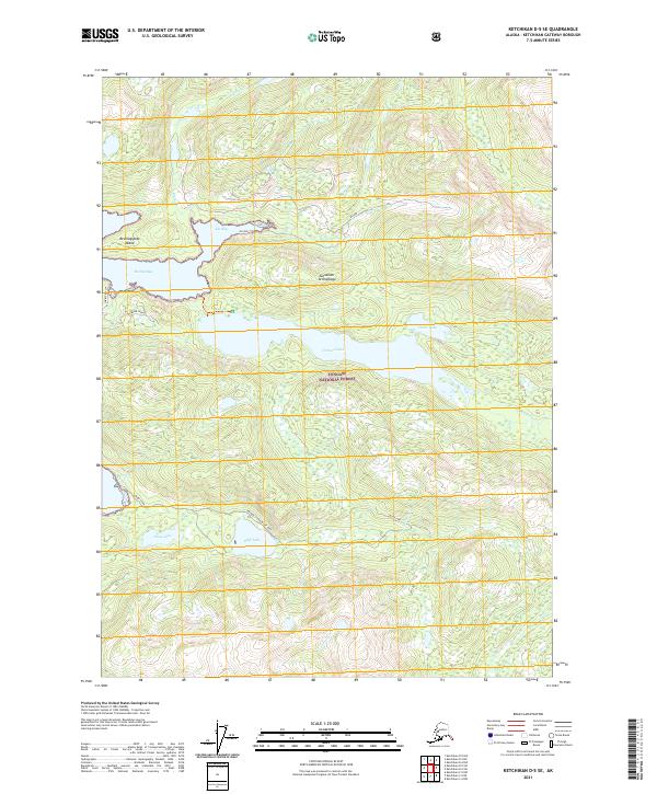
 2021 Ketchikan D-5 NW2021 Print · USGSThe wilderness of Southeast Alaska is documented here during the early twenty-first century, centered on the unique Bell Island Hot Springs. Researchers can trace remote coastal navigation points and interior water bodies like Hassler Pass, Behm Canal, and Lake Shelokum.
 - 2021 Map of Bradfield Canal A-2 SW, 2021 Print
 2021 Bradfield Canal A-2 SW2021 Print · USGSSoutheast Alaska in the early 2020s remains a wilderness of deep river valleys and managed forest. Researchers can trace the primary drainage systems of the Chickamin River and Leduc River as they flow through the Tongass National Forest.
 - 2021 Map of Bradfield Canal A-2 SE, 2021 Print
 2021 Bradfield Canal A-2 SE2021 Print · USGSSoutheast Alaska’s glacial wilderness is documented here in the early twenty-first century, showing the drainage of the Chickamin River and its massive ice fields. Researchers can trace the extents of Chickamin Glacier and Through Glacier near high summits like Mt Wilson.
 - 2021 Map of Bradfield Canal B-3 NW, 2021 Print
 2021 Bradfield Canal B-3 NW2021 Print · USGSThe international boundary with Canada and the high-elevation wilderness of the Tongass National Forest are captured here in the early 2020s. Researchers can trace the drainage of Lava Lakes into the Lava Fork and locate the rugged terrain of Albert Ridge.
 - 2021 Map of Ketchikan D-6 NW, 2021 Print
 2021 Ketchikan D-6 NW2021 Print · USGSThe coastal wilderness of the Cleveland Peninsula is captured here in the early twenty-first century, showing the intersection of maritime passages and forest land. Researchers can trace borough boundaries near Santa Anna Inlet, Table Mtn, and the shores of Lake McDonald.
 - 2021 Map of Bradfield Canal A-3 SW, 2021 Print
 2021 Bradfield Canal A-3 SW2021 Print · USGSSoutheast Alaska’s wilderness is mapped here in the early twenty-first century, showing the remote drainage of the Tongass National Forest. Researchers can trace the path of the Klahini River through high mountain terrain across several townships including T67S R93E and T67S R94E.
 - 2021 Map of Bradfield Canal A-4 NW, 2021 Print
 2021 Bradfield Canal A-4 NW2021 Print · USGSDeep in the Alaskan panhandle, this recent survey captures the intersection of the Tongass National Forest and the Coast Mountains. Researchers can trace the borough boundaries of Wrangell City and Borough across these high peaks.
 - 2021 Map of Bradfield Canal A-5 SE, 2021 Print
 2021 Bradfield Canal A-5 SE2021 Print · USGSSoutheast Alaska in the early twenty-first century remains a landscape of wilderness and waterways. Local historians and researchers can trace the reach of the Tongass National Forest and the remote shores of Eagle Lake and Bell Arm.
 - 2021 Map of Bradfield Canal A-4 SE, 2021 Print
 2021 Bradfield Canal A-4 SE2021 Print · USGSCoastal Southeast Alaska is defined by its dramatic glacial estuaries and river deltas at the turn of the twenty-first century. Researchers can trace the braided paths of the Unuk River and Eulachon River as they reach Burroughs Bay near Willow Islands.
 - 2021 Map of Bradfield Canal A-5 SW, 2021 Print
 2021 Bradfield Canal A-5 SW2021 Print · USGSSoutheast Alaska’s coastal wilderness is documented here in the early twenty-first century, showing the intersection of two major boroughs. Researchers can trace the path of the Reflection Lake Trl between Reflection Lake and the coastal waters of Short Bay.
 - 2021 Map of Bradfield Canal A-4 SW, 2021 Print
 2021 Bradfield Canal A-4 SW2021 Print · USGSCoastal wilderness and steep mountain terrain define this portion of the Alaska panhandle in the early twenty-first century. Researchers can trace the path of Grant Cr as it flows through the Tongass National Forest toward the Bradfield Canal.
Showing maps 1-25 of 143
Top cities of Ketchikan Gateway
Frequently asked questions
- What are the different types of historical maps available for Ketchikan Gateway?
- What is the oldest map of Ketchikan Gateway?
- Where can I purchase historical maps of Ketchikan Gateway for my home or office?
- Where can I download high-res historical maps of Ketchikan Gateway?
- Are there historical topographic maps available for Ketchikan Gateway?
- Is there historical aerial imagery available for Ketchikan Gateway?
- Where are historical maps of Ketchikan Gateway sourced from?