1900s (20th Century) Maps of Petersburg, Alaska
Explore 9 historic maps of Petersburg from the 1900s (20th Century). These maps offer a rare glimpse into what life looked like during the 1900s — showing old roads, neighborhoods, homes, and landmarks that have changed or disappeared over time.
Whether you're researching your family's past, planning a metal detecting trip, or studying how Petersburg's landscape evolved across the 1900s, these high-resolution maps are a powerful tool for exploring the history of this region.
- Focus on a specific era: All maps on this page are from the 1900s, giving you a focused view of this time period.
- See what’s changed: Compare century-old streets, trails, and buildings to today's modern landscape using overlays and satellite layers.
- Research with precision: Use these maps for genealogy, historical research, land use analysis, or educational projects.
- View, download, or print: Maps are fully viewable online in high resolution, and can be downloaded or printed for your own records.
Start exploring Petersburg's history through authentic maps from the 1900s. This is your window into the past.
Petersburg, AK maps
(9)- 1948 Map of Petersburg C-3, 1958 Print
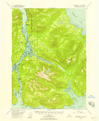 1948 Petersburg C-31958 Print · USGSMitkof Island and the Lindenberg Peninsula appear here in the late 1940s, mapped during an era of experimental agriculture and coastal navigation. Researchers can trace maritime landmarks like the Tonka (Aband) dock, the Alaska Experimental Fur Farm, and Hoffman Anchorage.
 - 1952 Map of Petersburg, 1953 Print
 1952 Petersburg1953 Print · USGSSoutheast Alaska's intricate Alexander Archipelago comes to life in the early fifties, documenting a landscape of remote island settlements and maritime corridors. Genealogists and historians can trace coastal life in Petersburg and Wrangell, or locate early industry at Shakan and regional Mines.5 unique versions available
 - 1953 Map of Petersburg C-3, 1964 Print
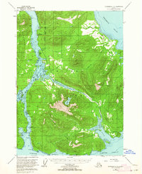 1953 Petersburg C-31964 Print · USGSMitkof Island and the Wrangell Narrows are shown here during the early 1950s as maritime industry and island infrastructure expanded. Researchers can locate specialized sites like the Alaska Experimental Fur Farm, Papkes Landing, and the original route of the Mitkof Highway.2 unique versions available
 - 1960 Map of Petersburg, 1966 Print
 1960 Petersburg1966 Print · USGSSoutheast Alaska's maritime landscape is captured here in the mid-1900s, showcasing the intricate island networks of the Alexander Archipelago. Researchers can trace historic shorelines and island settlements from Petersburg and Kake to the Wrangell Cemetery and the Stikine River.3 unique versions available
 - 1961 Map of Petersburg D-3, 1966 Print
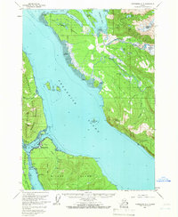 1961 Petersburg D-31966 Print · USGSSoutheast Alaska at the start of the 1960s centers on the bustling maritime hub of Petersburg along the Wrangell Narrows. Researchers can trace the waterfront infrastructure of the era, from the Seaplane Airport to the outlying settlements of West Petersburg and Doyhof.3 unique versions available
 - 1992 Map of Petersburg D-3 SW
 1992 Petersburg D-3 SW1992 Print · USGSSoutheast Alaska’s maritime character is on full display here in the early nineties, centered on the vital passage of Wrangell Narrows. Genealogists and local historians can trace the streets of Petersburg, find the town Cem, and locate coastal landmarks like Hammer Slough and Sasby Island.
 - 1992 Map of Petersburg C-3 NW
 1992 Petersburg C-3 NW1992 Print · USGSSoutheast Alaska’s maritime corridors come to life in the 1990s as this survey traces the intricate shoreline of the Wrangell Narrows. Genealogists and local historians can locate the Tonka (Site), explore the layout of Papkes Landing, and trace the path of the Mitkof Highway.
 - 1992 Map of Petersburg C-3 NE
 1992 Petersburg C-3 NE1992 Print · USGSMitkof Island in the early nineties features the rugged overlap of the Tongass National Forest and the waters of Frederick Sound. Genealogists and researchers can trace the coastal Petersburg Corporate Boundary and the interior Three Lakes Recreation Area near Sand Lake.
 - 1995 Map of Petersburg D-3
 1995 Petersburg D-31995 Print · USGSSoutheast Alaska's maritime character is on full display in the 1990s as the Alaska Marine Highway connects islands and inlets. Researchers can locate the waterfront footprints of Petersburg, Kupreanof, and Scow Bay or trace inland trails to the Ravens Roost Cabin.
End of results
Showing maps 1-9 of 9
Top cities near Petersburg
Top neighborhoods of Petersburg
Frequently asked questions
- What are the different types of historical maps available for Petersburg?
- What is the oldest map of Petersburg?
- Where can I purchase historical maps of Petersburg for my home or office?
- Where can I download high-res historical maps of Petersburg?
- Are there historical topographic maps available for Petersburg?
- Is there historical aerial imagery available for Petersburg?
- Where are historical maps of Petersburg sourced from?