1940s Maps of Benson, Arizona
Explore 2 historic maps of Benson from the 1940s. These maps offer a rare glimpse into what life looked like during the 1940s — showing old roads, neighborhoods, homes, and landmarks that have changed or disappeared over time.
Whether you're researching your family's past, planning a metal detecting trip, or studying how Benson's landscape evolved across the 1940s, these high-resolution maps are a powerful tool for exploring the history of this region.
- Focus on a specific era: All maps on this page are from the 1940s, giving you a focused view of this time period.
- See what’s changed: Compare century-old streets, trails, and buildings to today's modern landscape using overlays and satellite layers.
- Research with precision: Use these maps for genealogy, historical research, land use analysis, or educational projects.
- View, download, or print: Maps are fully viewable online in high resolution, and can be downloaded or printed for your own records.
Start exploring Benson's history through authentic maps from the 1940s. This is your window into the past.
Benson, AZ maps
(2)- 1943 Map of Benson
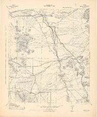 1943 Benson1943 Print · USGSCochise County during the wartime 1940s reveals a landscape defined by the San Pedro River and the legendary town of Tombstone. Genealogists and historians can trace the foundations of Fort Huachuca and locate rural landmarks like St David, Fairbank, and Huachuca Turner PO.
 - 1945 Map of Happy Valley
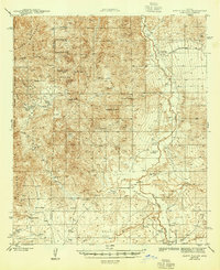 1945 Happy Valley1945 Print · USGSThe San Pedro River valley and the eastern slopes of the Rincon Mountains are documented here during the mid-1940s. Genealogists and historians can locate numerous family homesteads like Russell Ranch and Gunter Ranch, or trace the Willcox-Cascabel Road past the Apodaca Sch.2 unique versions available
End of results
Showing maps 1-2 of 2
Top cities near Benson
- Sierra Vista historical maps
- Whetstone historical maps
- Pomerene historical maps
- Sonoita historical maps
Frequently asked questions
- What are the different types of historical maps available for Benson?
- What is the oldest map of Benson?
- Where can I purchase historical maps of Benson for my home or office?
- Where can I download high-res historical maps of Benson?
- Are there historical topographic maps available for Benson?
- Is there historical aerial imagery available for Benson?
- Where are historical maps of Benson sourced from?