1970s Maps of Benson, Arizona
Explore 4 historic maps of Benson from the 1970s. These maps offer a rare glimpse into what life looked like during the 1970s — showing old roads, neighborhoods, homes, and landmarks that have changed or disappeared over time.
Whether you're researching your family's past, planning a metal detecting trip, or studying how Benson's landscape evolved across the 1970s, these high-resolution maps are a powerful tool for exploring the history of this region.
- Focus on a specific era: All maps on this page are from the 1970s, giving you a focused view of this time period.
- See what’s changed: Compare century-old streets, trails, and buildings to today's modern landscape using overlays and satellite layers.
- Research with precision: Use these maps for genealogy, historical research, land use analysis, or educational projects.
- View, download, or print: Maps are fully viewable online in high resolution, and can be downloaded or printed for your own records.
Start exploring Benson's history through authentic maps from the 1970s. This is your window into the past.
Benson, AZ maps
(4)- 1973 Map of Galleta Flat East, 1976 Print
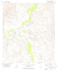 1973 Galleta Flat East1976 Print · USGSCochise County during the 1970s reveals a ranching landscape centered on the San Pedro River. Genealogists and historians can trace local landmarks like Singing Wind Ranch, the flats of Cornfield Flat, and the northern edge of Pomerene.
 - 1973 Map of Benson, 1976 Print
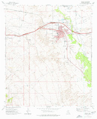 1973 Benson1976 Print · USGSBenson and the San Pedro Valley are shown in the early seventies as a thriving transportation hub where the railroad and new highway interchanges meet. Researchers can trace the layout of the Benson Cemetery, locate the High School, or find outlying landmarks like Post Ranch and the Benson Airport.2 unique versions available
 - 1973 Map of Mescal, 1976 Print
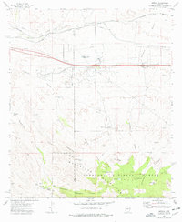 1973 Mescal1976 Print · USGSSoutheastern Arizona ranching and rail infrastructure are detailed here in the early seventies. You can trace family lands at the Double X Ranch, locate historic water sources like Wakefield Spring, or study the Southern Pacific Railroad corridor near Mescal.2 unique versions available
 - 1973 Map of McGrew Spring, 1976 Print
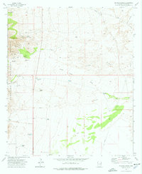 1973 McGrew Spring1976 Print · USGSCochise County in the early 1970s reveals a landscape of high-desert canyons and remote mining claims. Genealogists and historians can locate working sites like the Ricketts Mine, the watering holes of Mc Grew Spring, and the isolated French Joe Camp.2 unique versions available
End of results
Showing maps 1-4 of 4
Top cities near Benson
- Sierra Vista historical maps
- Whetstone historical maps
- Pomerene historical maps
- Sonoita historical maps
Frequently asked questions
- What are the different types of historical maps available for Benson?
- What is the oldest map of Benson?
- Where can I purchase historical maps of Benson for my home or office?
- Where can I download high-res historical maps of Benson?
- Are there historical topographic maps available for Benson?
- Is there historical aerial imagery available for Benson?
- Where are historical maps of Benson sourced from?