1990s Maps of Benson, Arizona
Explore 6 historic maps of Benson from the 1990s. These maps offer a rare glimpse into what life looked like during the 1990s — showing old roads, neighborhoods, homes, and landmarks that have changed or disappeared over time.
Whether you're researching your family's past, planning a metal detecting trip, or studying how Benson's landscape evolved across the 1990s, these high-resolution maps are a powerful tool for exploring the history of this region.
- Focus on a specific era: All maps on this page are from the 1990s, giving you a focused view of this time period.
- See what’s changed: Compare century-old streets, trails, and buildings to today's modern landscape using overlays and satellite layers.
- Research with precision: Use these maps for genealogy, historical research, land use analysis, or educational projects.
- View, download, or print: Maps are fully viewable online in high resolution, and can be downloaded or printed for your own records.
Start exploring Benson's history through authentic maps from the 1990s. This is your window into the past.
Benson, AZ maps
(6)- 1994 Map of Fort Huachuca
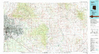
 1994 Fort Huachuca1994 Print · USGSSouthern Arizona in the mid-nineties shows a landscape of expansive military reservations, historic land grants, and storied mining districts. Researchers can trace the S P RR through the San Pedro River valley or locate dozens of remote mountain workings like the Montezuma Mine and Eureka Mine.3 unique versions available
 - 1994 Map of Tucson
 1994 Tucson1994 Print · USGSTucson and the Santa Cruz Valley appear here in the mid-1990s, caught between rapid urban growth and protected wilderness. Researchers can trace the development of Casas Adobes, the operations at Davis Monthan Air Force Base, and the rail lines of the Southern Pacific RR.2 unique versions available
 - 1996 Map of Galleta Flat East, 2002 Print
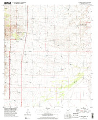
 1996 Galleta Flat East2002 Print · USGSCochise County ranching and desert waterways are captured in the 1990s as modern imagery updated the valley landscape. Researchers can trace land use at Singing Wind Ranch or follow drainage patterns along Ash Creek and Tres Alamos Wash.
 - 1996 Map of Mc Grew Spring, 2002 Print
 1996 Mc Grew Spring2002 Print · USGSCochise County’s high desert landscape is captured here in the late twentieth century as suburban growth and conservation efforts began to overlap. Metal detectorists and local historians can trace old mining prospects like H & D Mine and remote camps such as French Joe Camp.
 - 1996 Map of Benson, 2002 Print
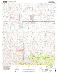
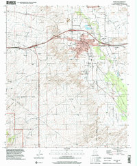 1996 Benson2002 Print · USGSThe San Pedro Valley during the late twentieth century shows the growth of Benson from a rail town into a regional center. Genealogists and historians can trace the Benson Cem, local schools, and outlying settlements like Chamiso or Pomerene.
 - 1996 Map of Mescal, 2002 Print
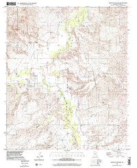
 1996 Mescal2002 Print · USGSThe Whetstone Mountains and Pima-Cochise county line meet in this late-twentieth-century study of the Arizona high desert. Researchers can trace the legacy of cattle ranching and water rights through landmarks like Double X Ranch, Wakefield Spring, and the Old Railroad Grade.
End of results
Showing maps 1-6 of 6
Top cities near Benson
- Sierra Vista historical maps
- Whetstone historical maps
- Pomerene historical maps
- Sonoita historical maps
Frequently asked questions
- What are the different types of historical maps available for Benson?
- What is the oldest map of Benson?
- Where can I purchase historical maps of Benson for my home or office?
- Where can I download high-res historical maps of Benson?
- Are there historical topographic maps available for Benson?
- Is there historical aerial imagery available for Benson?
- Where are historical maps of Benson sourced from?