1910s Maps of Sierra Vista, Arizona
Explore 2 historic maps of Sierra Vista from the 1910s. These maps offer a rare glimpse into what life looked like during the 1910s — showing old roads, neighborhoods, homes, and landmarks that have changed or disappeared over time.
Whether you're researching your family's past, planning a metal detecting trip, or studying how Sierra Vista's landscape evolved across the 1910s, these high-resolution maps are a powerful tool for exploring the history of this region.
- Focus on a specific era: All maps on this page are from the 1910s, giving you a focused view of this time period.
- See what’s changed: Compare century-old streets, trails, and buildings to today's modern landscape using overlays and satellite layers.
- Research with precision: Use these maps for genealogy, historical research, land use analysis, or educational projects.
- View, download, or print: Maps are fully viewable online in high resolution, and can be downloaded or printed for your own records.
Start exploring Sierra Vista's history through authentic maps from the 1910s. This is your window into the past.
Sierra Vista, AZ maps
(2)- 1914 Map of Hereford
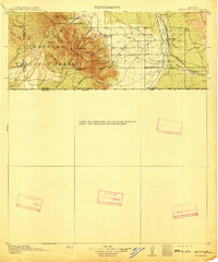 1914 Hereford1914 Print · USGSUpper Cochise County reveals its early ranching and mining character just before the Great War. Genealogists and historians can trace remote mountain settlements like Sunnyside and Hamburg or the railway path of the El Paso and Southwestern.3 unique versions available
 - 1915 Map of Benson
 1915 Benson1915 Print · USGSSouthern Arizona was a landscape of rail junctions and mining claims just before the Great War. Genealogists and historians can trace the reach of Tombstone, find the Panama Mine, and locate vanished rail stops like Fairbank and Boquillas.4 unique versions available
End of results
Showing maps 1-2 of 2
Top cities near Sierra Vista
Top neighborhoods of Sierra Vista
- Ramsey historical maps
- Bledsoe historical maps
- West Pershing Plaza historical maps
- Village Meadows historical maps
- Apache Flats historical maps
- Fry historical maps
See more
Frequently asked questions
- What are the different types of historical maps available for Sierra Vista?
- What is the oldest map of Sierra Vista?
- Where can I purchase historical maps of Sierra Vista for my home or office?
- Where can I download high-res historical maps of Sierra Vista?
- Are there historical topographic maps available for Sierra Vista?
- Is there historical aerial imagery available for Sierra Vista?
- Where are historical maps of Sierra Vista sourced from?