1900-1909 Maps of Coconino County, Arizona
Explore 5 historic maps of Coconino County from 1900-1909. These maps offer a rare glimpse into what life looked like during the 1900s — showing old roads, neighborhoods, homes, and landmarks that have changed or disappeared over time.
Whether you're researching your family's past, planning a metal detecting trip, or studying how Coconino County's landscape evolved across the 1900s, these high-resolution maps are a powerful tool for exploring the history of this region.
- Focus on a specific era: All maps on this page are from the 1900s, giving you a focused view of this time period.
- See what’s changed: Compare century-old streets, trails, and buildings to today's modern landscape using overlays and satellite layers.
- Research with precision: Use these maps for genealogy, historical research, land use analysis, or educational projects.
- View, download, or print: Maps are fully viewable online in high resolution, and can be downloaded or printed for your own records.
Start exploring Coconino County's history through authentic maps from the 1900s. This is your window into the past.
Coconino County, AZ maps
(5)- 1903 Map of Bright Angel
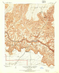 1903 Bright Angel1903 Print · USGSCoconino County at the turn of the century shows the initial footprint of modern tourism as rail lines reach the canyon rim. Researchers can trace the original paths of the Bright Angel Trail and locate early sites like the El Tovar Hotel and Phantom Ranch.4 unique versions available
 - 1905 Map of Jerome
 1905 Jerome1905 Print · USGSArizona's copper mining and ranching frontiers come to life in this early century survey of the Verde Valley. Trace the narrow-gauge United Verde and Pacific RR as it climbs toward Jerome, or locate family-named sites like Carter's Ranch and Perkins Ranch.2 unique versions available
 - 1906 Map of Bright Angel
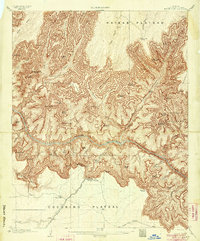 1906 Bright Angel1906 Print · USGSArizona's most famous natural wonder is documented here in the early years of the century as the rail lines first reached the rim. Trace the early routes of the Bright Angel Trail and the Grand Canyon R. R. into the settlement of Grand Canyon.9 unique versions available
 - 1907 Map of Vishnu
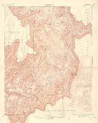 1907 Vishnu1907 Print · USGSCoconino County was a landscape of deep canyons and named temples at the turn of the century. Trace the early paths of the Tonto Trail or locate isolated water sources like O'Neill Spring and the lone Cabin near the Painted Desert.3 unique versions available
 - 1908 Map of Flagstaff, 1960 Print
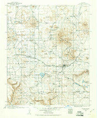 1908 Flagstaff1960 Print · USGSNorthern Arizona's high country is captured here during the early twentieth century, showing the rail and ranching roots of the Coconino plateau. Genealogists and historians can trace early settlements like Bellemont, scientific landmarks like Lowell Observatory, and the timber works at Greenlaw's Mill.
End of results
Showing maps 1-5 of 5
Top cities of Coconino County
- Flagstaff historical maps
- Page historical maps
- Doney Park historical maps
- Williams historical maps
- Kachina Village historical maps
- Timberline-Fernwood historical maps
See more
Frequently asked questions
- What are the different types of historical maps available for Coconino County?
- What is the oldest map of Coconino County?
- Where can I purchase historical maps of Coconino County for my home or office?
- Where can I download high-res historical maps of Coconino County?
- Are there historical topographic maps available for Coconino County?
- Is there historical aerial imagery available for Coconino County?
- Where are historical maps of Coconino County sourced from?