1900s (20th Century) Maps of Coconino County, Arizona
Explore 544 historic maps of Coconino County from the 1900s (20th Century). These maps offer a rare glimpse into what life looked like during the 1900s — showing old roads, neighborhoods, homes, and landmarks that have changed or disappeared over time.
Whether you're researching your family's past, planning a metal detecting trip, or studying how Coconino County's landscape evolved across the 1900s, these high-resolution maps are a powerful tool for exploring the history of this region.
- Focus on a specific era: All maps on this page are from the 1900s, giving you a focused view of this time period.
- See what’s changed: Compare century-old streets, trails, and buildings to today's modern landscape using overlays and satellite layers.
- Research with precision: Use these maps for genealogy, historical research, land use analysis, or educational projects.
- View, download, or print: Maps are fully viewable online in high resolution, and can be downloaded or printed for your own records.
Start exploring Coconino County's history through authentic maps from the 1900s. This is your window into the past.
Coconino County, AZ maps
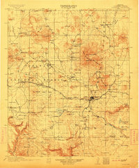
(544)- 1903 Map of Bright Angel
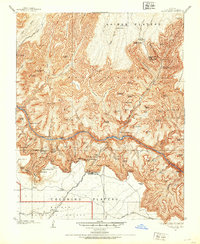 1903 Bright Angel1903 Print · USGSCoconino County at the turn of the century shows the initial footprint of modern tourism as rail lines reach the canyon rim. Researchers can trace the original paths of the Bright Angel Trail and locate early sites like the El Tovar Hotel and Phantom Ranch.4 unique versions available
 - 1905 Map of Jerome
 1905 Jerome1905 Print · USGSArizona's copper mining and ranching frontiers come to life in this early century survey of the Verde Valley. Trace the narrow-gauge United Verde and Pacific RR as it climbs toward Jerome, or locate family-named sites like Carter's Ranch and Perkins Ranch.2 unique versions available
 - 1906 Map of Bright Angel
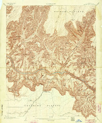 1906 Bright Angel1906 Print · USGSArizona's most famous natural wonder is documented here in the early years of the century as the rail lines first reached the rim. Trace the early routes of the Bright Angel Trail and the Grand Canyon R. R. into the settlement of Grand Canyon.9 unique versions available
 - 1907 Map of Vishnu
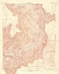 1907 Vishnu1907 Print · USGSCoconino County was a landscape of deep canyons and named temples at the turn of the century. Trace the early paths of the Tonto Trail or locate isolated water sources like O'Neill Spring and the lone Cabin near the Painted Desert.3 unique versions available
 - 1908 Map of Flagstaff, 1960 Print
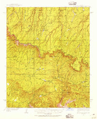
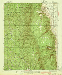
 1908 Flagstaff1960 Print · USGSNorthern Arizona's high country is captured here during the early twentieth century, showing the rail and ranching roots of the Coconino plateau. Genealogists and historians can trace early settlements like Bellemont, scientific landmarks like Lowell Observatory, and the timber works at Greenlaw's Mill.
 - 1912 Map of Flagstaff
 1912 Flagstaff1912 Print · USGSFlagstaff and the surrounding Coconino highlands appear here during a period of steady growth along the railroad. Genealogists and historians can locate early family sites like Darden's Ranch, the Lowell Observatory, and Greenlaw's Mill.5 unique versions available
 - 1922 Map of Warm Creek
 1922 Warm Creek1922 Print · USGSSouthern Utah's canyon country appears here in the early twenties, just as the first formal topographic surveys reached the Colorado River. Researchers can trace the legendary Crossing of the Fathers and locate the remote Warm Creek Cabin near the Utah-Arizona Boundary Line.
 - 1922 Map of Williams
 1922 Williams1922 Print · USGSNorthern Arizona's high plateau during the early 1920s reveals a landscape of forestry and rail expansion. Trace early ranger stations and small rail stops like Fairview, Meath, and the Wood Spur logging line.
 - 1923 Map of Camp Verde
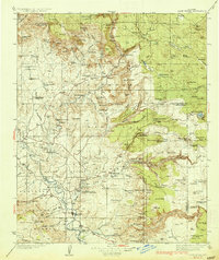
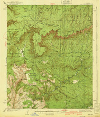
 1923 Camp Verde1923 Print · USGSCentral Arizona's river valleys and high plateaus appear here during the early twenties, showing the region's shift toward tourism and settlement. Trace the routes to Montezuma Castle Nat Monument or locate early sites like Cornville and Aultman.
 - 1929 Map of Turret Peak, 1958 Print
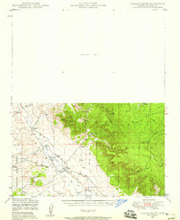
 1929 Turret Peak1958 Print · USGSYavapai County ranching and mining reach their peak in the late twenties along the winding Verde River. Researchers can trace the legacy of early families and industrial ventures at the United Arizona Mine, Brown Springs Ranch, and Anchor Ranch.3 unique versions available
 - 1932 Map of Camp Verde, 1959 Print
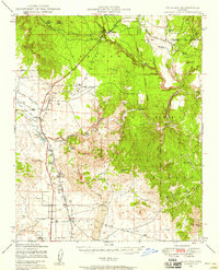
 1932 Camp Verde1959 Print · USGSThe Verde Valley and the Mogollon Rim are documented here in the early 1930s, showing a landscape of remote cattle ranches and historic ruins. Researchers can trace early schools and homesteads like Red Rock Sch, Middle Verde, and Indian Gardens alongside Montezuma Well.2 unique versions available
 - 1933 Map of Turret Peak
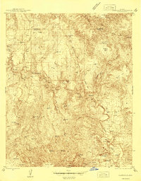
 1933 Turret Peak1933 Print · USGSArizona's central highlands come alive in the 1930s as a land of remote mining claims and isolated ranching outposts. Trace the early copper industry at the Copper Queen Mine and Rosalie Mine, or locate family sites like the Dugan Ranch and Dugas near the Verde River.3 unique versions available
 - 1934 Map of Pine
 1934 Pine1934 Print · USGSIn the mid-1930s, the dramatic Mogollon Rim divided Arizona's high timberlands from the rugged canyon country. Genealogists and historians can trace early mountain life through the Crackerjack Mine, the Natural Bridge, and the Chase Ranch.2 unique versions available
 - 1934 Map of Promontory Butte, 1955 Print
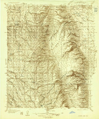
 1934 Promontory Butte1955 Print · USGSThe Mogollon Rim country of Gila and Coconino Counties is captured in the mid-thirties, showcasing a network of remote homesteads and forest service outposts. Trace family history and early mountain life at sites like the Zane Grey Lodge, Haught Sawmill, and the Fred Haught Cabin.
 - 1936 Map of Camp Verde
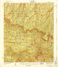
 1936 Camp Verde1936 Print · USGSThe Verde Valley and Red Rock country are captured in the mid-1930s, showing a landscape of pioneer ranches and ancient ruins. Researchers can locate the early footprints of Sedona and Camp Verde, alongside remote landmarks like Montezuma Castle National Monument and the Stoneman Lake area.3 unique versions available
 - 1936 Map of Jacobs Lake
 1936 Jacobs Lake1936 Print · USGSThe Kaibab Plateau in the mid-1930s was a landscape of high-altitude forests and remote truck trails. Genealogists and researchers can trace the early road network of U S Highway No 89 and locate isolated outposts like the Jacobs Lake Ranger Station.
 - 1939 Map of Promontory Butte
 1939 Promontory Butte1939 Print · USGSArizona's rim country comes alive in the late 1930s, showing the early ranches and forest outposts that predated modern recreation. Trace the locations of historic homesteads like Zane Grey Lodge, the Haught Sawmill, and the Buck Springs Guard Station.3 unique versions available
 - 1940 Map of Jacob Lake
 1940 Jacob Lake1940 Print · USGSThe high plateau of the Arizona Strip is captured here in the mid-1930s, showing the early forest service and ranching footprint. You can trace the historic Kane Trail, locate the Jacob Lake Ranger Sta, and identify remote watering spots like Kane Springs.2 unique versions available
 - 1940 Map of Pine
 1940 Pine1940 Print · USGSThe northern Arizona highlands are captured here in the mid-1930s, showing the rugged divide of the Mogollon Rim. Local historians can trace early settlements at Pine and Strawberry, along with remote sites like Chase Ranch and the White Mtn Mine.
 - 1944 Map of Clarkdale
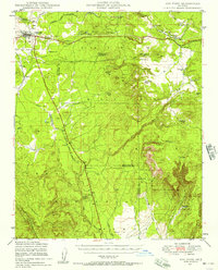
 1944 Clarkdale1944 Print · USGSThe Verde Valley during the mid-1940s shows a complex network of mining infrastructure and ancient history. Local historians can trace the industrial footprint of the Smelter in Clarkdale and the archaeological site at Tuzigoot Nat Mon.5 unique versions available
 - 1947 Map of Flagstaff, 1948 Print
 1947 Flagstaff1948 Print · USGSThe Arizona high country and the Painted Desert converge in this post-war survey. Researchers can trace the ancient mesa villages of Walpi and Oraibi, the early roads of Flagstaff, and landmarks like Sunset Crater National Monument.2 unique versions available
 - 1947 Map of Ash Fork, 1957 Print
 1947 Ash Fork1957 Print · USGSThe high desert around Ash Fork was a vital rail and ranching corridor in the late 1940s. Genealogists and historians can trace the Atchison Topeka & Santa Fe line past Evans Ranch and remote water features like Irishman Dam.3 unique versions available
 - 1947 Map of Picacho Butte, 1958 Print
 1947 Picacho Butte1958 Print · USGSArizona's high desert ranching country comes into focus in the late 1940s, showcasing the isolated cattle operations and water works of Yavapai County. Genealogists and historians can trace family-named sites like Fritsche Ranch and CV Ranch or locate early infrastructure such as Cotton Dam.2 unique versions available
 - 1947 Map of Paulden, 1958 Print
 1947 Paulden1958 Print · USGSCentral Arizona ranching and rail history come alive in this late 1940s survey of the Chino Valley. Genealogists and historians can trace the Atchison Topeka and Santa Fe line past Drake, Sullivan Lake, and the historic Del Rio Ranch.3 unique versions available
 - 1948 Map of Ash Fork
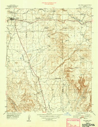 1948 Ash Fork1948 Print · USGSIn the late 1940s, the railroad town of Ashfork served as a gateway to the ranching country at the edge of the Coconino plateau. Researchers can trace the water-management history of the high desert through features like Irishman Dam, McLellan Res, and the Quarter Circle XX Ranch.
Showing maps 1-25 of 544
Top cities of Coconino County
- Flagstaff historical maps
- Page historical maps
- Doney Park historical maps
- Williams historical maps
- Kachina Village historical maps
- Timberline-Fernwood historical maps
See more
Frequently asked questions
- What are the different types of historical maps available for Coconino County?
- What is the oldest map of Coconino County?
- Where can I purchase historical maps of Coconino County for my home or office?
- Where can I download high-res historical maps of Coconino County?
- Are there historical topographic maps available for Coconino County?
- Is there historical aerial imagery available for Coconino County?
- Where are historical maps of Coconino County sourced from?