1940s Maps of Coconino County, Arizona
Explore 13 historic maps of Coconino County from the 1940s. These maps offer a rare glimpse into what life looked like during the 1940s — showing old roads, neighborhoods, homes, and landmarks that have changed or disappeared over time.
Whether you're researching your family's past, planning a metal detecting trip, or studying how Coconino County's landscape evolved across the 1940s, these high-resolution maps are a powerful tool for exploring the history of this region.
- Focus on a specific era: All maps on this page are from the 1940s, giving you a focused view of this time period.
- See what’s changed: Compare century-old streets, trails, and buildings to today's modern landscape using overlays and satellite layers.
- Research with precision: Use these maps for genealogy, historical research, land use analysis, or educational projects.
- View, download, or print: Maps are fully viewable online in high resolution, and can be downloaded or printed for your own records.
Start exploring Coconino County's history through authentic maps from the 1940s. This is your window into the past.
Coconino County, AZ maps
(13)- 1940 Map of Jacob Lake
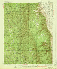 1940 Jacob Lake1940 Print · USGSThe high plateau of the Arizona Strip is captured here in the mid-1930s, showing the early forest service and ranching footprint. You can trace the historic Kane Trail, locate the Jacob Lake Ranger Sta, and identify remote watering spots like Kane Springs.2 unique versions available
 - 1940 Map of Pine
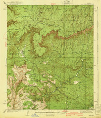 1940 Pine1940 Print · USGSThe northern Arizona highlands are captured here in the mid-1930s, showing the rugged divide of the Mogollon Rim. Local historians can trace early settlements at Pine and Strawberry, along with remote sites like Chase Ranch and the White Mtn Mine.
 - 1944 Map of Clarkdale
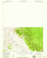
 1944 Clarkdale1944 Print · USGSThe Verde Valley during the mid-1940s shows a complex network of mining infrastructure and ancient history. Local historians can trace the industrial footprint of the Smelter in Clarkdale and the archaeological site at Tuzigoot Nat Mon.5 unique versions available
 - 1947 Map of Flagstaff, 1948 Print
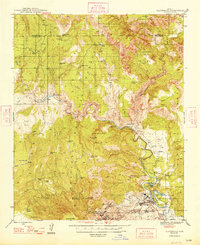
 1947 Flagstaff1948 Print · USGSThe Arizona high country and the Painted Desert converge in this post-war survey. Researchers can trace the ancient mesa villages of Walpi and Oraibi, the early roads of Flagstaff, and landmarks like Sunset Crater National Monument.2 unique versions available
 - 1947 Map of Ash Fork, 1957 Print
 1947 Ash Fork1957 Print · USGSThe high desert around Ash Fork was a vital rail and ranching corridor in the late 1940s. Genealogists and historians can trace the Atchison Topeka & Santa Fe line past Evans Ranch and remote water features like Irishman Dam.3 unique versions available
 - 1947 Map of Picacho Butte, 1958 Print
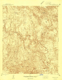
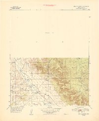
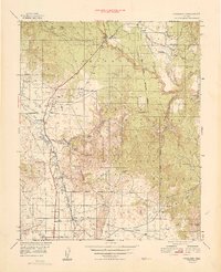
 1947 Picacho Butte1958 Print · USGSArizona's high desert ranching country comes into focus in the late 1940s, showcasing the isolated cattle operations and water works of Yavapai County. Genealogists and historians can trace family-named sites like Fritsche Ranch and CV Ranch or locate early infrastructure such as Cotton Dam.2 unique versions available
 - 1947 Map of Paulden, 1958 Print
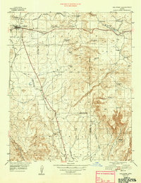
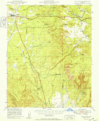
 1947 Paulden1958 Print · USGSCentral Arizona ranching and rail history come alive in this late 1940s survey of the Chino Valley. Genealogists and historians can trace the Atchison Topeka and Santa Fe line past Drake, Sullivan Lake, and the historic Del Rio Ranch.3 unique versions available
 - 1948 Map of Ash Fork
 1948 Ash Fork1948 Print · USGSIn the late 1940s, the railroad town of Ashfork served as a gateway to the ranching country at the edge of the Coconino plateau. Researchers can trace the water-management history of the high desert through features like Irishman Dam, McLellan Res, and the Quarter Circle XX Ranch.
 - 1948 Map of Williams
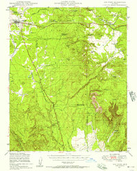
 1948 Williams1948 Print · USGSNorthern Arizona is captured here during the post-war era of roadside travel and heavy rail transport along the Santa Fe line. Researchers can trace the path of Route 66 through settlements like Seligman, Valentine, and Hackberry while exploring the vast terrain of the Hualpai Indian Reservation.2 unique versions available
 - 1948 Map of Picacho Butte
 1948 Picacho Butte1948 Print · USGSArizona ranching and forest lands are captured here just after the war, showing the working landscape of Yavapai County. Researchers can trace historic property boundaries and water infrastructure at K4 Farm, CV Ranch, and Mexican Dam.
 - 1948 Map of Clarkdale
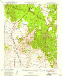
 1948 Clarkdale1948 Print · USGSThe mining and smelting centers of the Verde Valley are at their mid-century peak in this survey. Genealogists and industrial historians can trace the United Verde Mine, the neighborhoods of Clarkdale, and remote outposts like Perkinsville along the river rail line.
 - 1949 Map of Paulden
 1949 Paulden1949 Print · USGSHigh desert ranching and rail infrastructure define this portion of Yavapai County in the late forties. Researchers can trace historic family holdings like Del Rio Ranch and Bar Heart Ranch alongside the Atchison Topeka and Santa Fe rail line.
 - 1949 Map of Ash Fork
 1949 Ash Fork1949 Print · USGSAsh Fork and the surrounding high plateau of northern Arizona are captured here in the late 1940s as rail and ranching dominated the landscape. Genealogists and local historians can trace family-named sites like Brown Place, Evans Ranch, and the railway junction at Sereno.
End of results
Showing maps 1-13 of 13
Top cities of Coconino County
- Flagstaff historical maps
- Page historical maps
- Doney Park historical maps
- Williams historical maps
- Kachina Village historical maps
- Timberline-Fernwood historical maps
See more
Frequently asked questions
- What are the different types of historical maps available for Coconino County?
- What is the oldest map of Coconino County?
- Where can I purchase historical maps of Coconino County for my home or office?
- Where can I download high-res historical maps of Coconino County?
- Are there historical topographic maps available for Coconino County?
- Is there historical aerial imagery available for Coconino County?
- Where are historical maps of Coconino County sourced from?