1980s Maps of Page, Arizona
Explore 7 historic maps of Page from the 1980s. These maps offer a rare glimpse into what life looked like during the 1980s — showing old roads, neighborhoods, homes, and landmarks that have changed or disappeared over time.
Whether you're researching your family's past, planning a metal detecting trip, or studying how Page's landscape evolved across the 1980s, these high-resolution maps are a powerful tool for exploring the history of this region.
- Focus on a specific era: All maps on this page are from the 1980s, giving you a focused view of this time period.
- See what’s changed: Compare century-old streets, trails, and buildings to today's modern landscape using overlays and satellite layers.
- Research with precision: Use these maps for genealogy, historical research, land use analysis, or educational projects.
- View, download, or print: Maps are fully viewable online in high resolution, and can be downloaded or printed for your own records.
Start exploring Page's history through authentic maps from the 1980s. This is your window into the past.
Page, AZ maps
(7)- 1981 Map of Lone Rock, 1982 Print
 1981 Lone Rock1982 Print · USGSThe high desert borderlands of Utah and Arizona are captured here in the early eighties as the waters of Lake Powell filled the canyon floor. Researchers can trace the rugged shoreline of Wahweap Bay to find isolated Mines, Skylight Arch, and the namesake Lone Rock.3 unique versions available
 - 1984 Map of Glen Canyon Dam
 1984 Glen Canyon Dam1984 Print · USGSThe Colorado River corridor near the Utah border is captured here in the mid-eighties, centered on the rise of modern infrastructure in the desert. Researchers can trace the development of Page alongside historic sites like Lees Ferry and the Copper Mine Trading Post.2 unique versions available
 - 1985 Map of Smoky Mountain
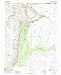
 1985 Smoky Mountain1985 Print · USGSSouthern Utah in the mid-eighties was a landscape of rising reservoir waters and vast desert plateaus. Genealogists and historians can trace the topography around Adairville, the intricate shorelines of Lake Powell, and prominent heights like Navajo Mountain.2 unique versions available
 - 1985 Map of Ferry Swale
 1985 Ferry Swale1985 Print · USGSThe high desert canyons north of the Colorado River are captured here in the mid-eighties as recreation and ranching converged. Researchers can trace the rugged topography of Thousand Pockets or locate desert water sources like Wildcat Tank and Hackberry Tank.2 unique versions available
 - 1985 Map of White Dome
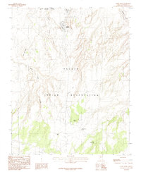 1985 White Dome1985 Print · USGSThe Navajo Indian Reservation in the mid-1980s reveals a landscape of high desert mesas and tribal centers. Researchers can trace landforms like Wide Flat Mesa and find localized settlements such as Leche-e Chapter or The Paved Place.
 - 1985 Map of Lees Ferry
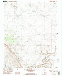
 1985 Lees Ferry1985 Print · USGSThe Colorado River corridor near the Navajo border is documented here in the mid-eighties, centered on the historic river crossing. Researchers can locate the Lees Ferry settlement, trace the Echo Cliffs, and find local landmarks like Navajo Spring.
 - 1985 Map of Page, 1986 Print
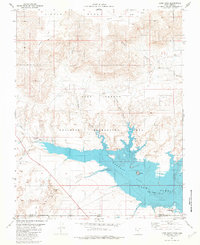
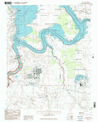 1985 Page1986 Print · USGSThe high-desert city of Page is shown in the mid-1980s, serving as a hub for the Glen Canyon Dam and Navajo lands. Researchers can trace the layout of Page on Manson Mesa and identify local landmarks like the Municipal Airport, Wahweap, and the Glen Canyon Dam.2 unique versions available
End of results
Showing maps 1-7 of 7
Top cities near Page
Frequently asked questions
- What are the different types of historical maps available for Page?
- What is the oldest map of Page?
- Where can I purchase historical maps of Page for my home or office?
- Where can I download high-res historical maps of Page?
- Are there historical topographic maps available for Page?
- Is there historical aerial imagery available for Page?
- Where are historical maps of Page sourced from?