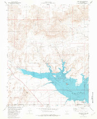
1981 Map of Lone Rock
USGS Topo · Published 1982About this map
Lake Powell dominates the southern reaches of this high desert landscape, marking the intersection of the Utah-Arizona border within the Glen Canyon National Recreation Area. The 1981 survey illustrates the intricate shoreline of Wahweap Bay, where the iconic Lone Rock stands as a prominent sentinel. To the north and west, the terrain rises into complex plateaus and drainage systems, including Nipple Bench and the carved depths of Wiregrass Canyon.
Find a feature on this map
23 named features on this map. Tap any name to fly to it.
Don’t see what you’re looking for? This feature index may not catch every label — zoom into the map to look around manually.
Map Details
Editions of this 1981 Lone Rock Map
3 editions found
Other maps of this area

1886 · Escalante
USGS Topo · 1:250,000

1886 · Echo Cliffs
USGS Topo · 1:250,000

1891 · Echo Cliffs
USGS Topo · 1:250,000

1922 · Warm Creek
USGS Topo · 1:63,360

1951 · Lees Ferry NE
USGS Topo · 1:24,000

1953 · Nipple Butte
USGS Topo · 1:62,500

1953 · Gunsight Butte
USGS Topo · 1:62,500

1954 · Lees Ferry NW
USGS Topo · 1:24,000

1954 · Leche-E Rock
USGS Topo · 1:62,500

1954 · Lees Ferry
USGS Topo · 1:62,500