1990s Maps of Page, Arizona
Explore 2 historic maps of Page from the 1990s. These maps offer a rare glimpse into what life looked like during the 1990s — showing old roads, neighborhoods, homes, and landmarks that have changed or disappeared over time.
Whether you're researching your family's past, planning a metal detecting trip, or studying how Page's landscape evolved across the 1990s, these high-resolution maps are a powerful tool for exploring the history of this region.
- Focus on a specific era: All maps on this page are from the 1990s, giving you a focused view of this time period.
- See what’s changed: Compare century-old streets, trails, and buildings to today's modern landscape using overlays and satellite layers.
- Research with precision: Use these maps for genealogy, historical research, land use analysis, or educational projects.
- View, download, or print: Maps are fully viewable online in high resolution, and can be downloaded or printed for your own records.
Start exploring Page's history through authentic maps from the 1990s. This is your window into the past.
Page, AZ maps
(2)- 1997 Map of Ferry Swale, 2003 Print
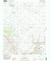 1997 Ferry Swale2003 Print · USGSCoconino County’s high-desert canyons and plateaus are captured here in the late twentieth century. Researchers can trace historic water sources like Bishops Tank and explore geographic landmarks including Thousand Pockets and Ferry Swale.
 - 1999 Map of Lees Ferry, 2003 Print
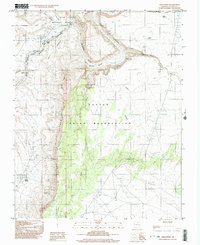 1999 Lees Ferry2003 Print · USGSThe Colorado River corridor near the Navajo Indian Reservation comes alive in this late-century survey of the historic crossing at Lees Ferry. Genealogists and researchers can trace the vicinity of Navajo Spring, a local Cem, and various prospects along the canyon rim.
End of results
Showing maps 1-2 of 2
Top cities near Page
Frequently asked questions
- What are the different types of historical maps available for Page?
- What is the oldest map of Page?
- Where can I purchase historical maps of Page for my home or office?
- Where can I download high-res historical maps of Page?
- Are there historical topographic maps available for Page?
- Is there historical aerial imagery available for Page?
- Where are historical maps of Page sourced from?