1940s Maps of Parker, Arizona
Explore 4 historic maps of Parker from the 1940s. These maps offer a rare glimpse into what life looked like during the 1940s — showing old roads, neighborhoods, homes, and landmarks that have changed or disappeared over time.
Whether you're researching your family's past, planning a metal detecting trip, or studying how Parker's landscape evolved across the 1940s, these high-resolution maps are a powerful tool for exploring the history of this region.
- Focus on a specific era: All maps on this page are from the 1940s, giving you a focused view of this time period.
- See what’s changed: Compare century-old streets, trails, and buildings to today's modern landscape using overlays and satellite layers.
- Research with precision: Use these maps for genealogy, historical research, land use analysis, or educational projects.
- View, download, or print: Maps are fully viewable online in high resolution, and can be downloaded or printed for your own records.
Start exploring Parker's history through authentic maps from the 1940s. This is your window into the past.
Parker, AZ maps
(4)- 1942 Map of Blythe
 1942 Blythe1942 Print · USGSThe Lower Colorado River valley appears here in the early 1940s, showcasing the agricultural development of the Palo Verde Mesa alongside a booming mining industry. Researchers can locate remote desert outposts and extraction sites like Midland, the U S Gypsum Mine, and Nortons Landing.2 unique versions available
 - 1942 Map of MOON MTN, 1943 Print
 1942 MOON MTN1943 Print · USGSThe Colorado River valley and its surrounding desert ranges are shown here during the height of the Second World War. Historians can trace the locations of the Parker Alien Reception Center units and former workings at Valenzuella Mines.
 - 1943 Map of Parker
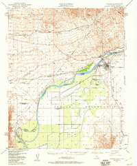
 1943 Parker1943 Print · USGSThe Lower Colorado riverfront was a vital military and transport corridor during the 1940s. Genealogists and historians can trace the rail and river network connecting Parker to the Colorado River Indian Reservation, Agency, and Doyles Landing.
 - 1949 Map of Parker, 1960 Print
 1949 Parker1960 Print · USGSThe Colorado River borderlands in the late 1940s show a fascinating mix of tribal lands, railroad stops, and desert mining. Genealogists and historians can locate the Mojave Indian Ch, the Cremation Ground, and the old Colorado River Day Sch within the reservation.2 unique versions available
End of results
Showing maps 1-4 of 4
Top cities near Parker
- Parker historical maps
- Cienega Springs historical maps
- Big River historical maps
- Bouse historical maps
- Bluewater historical maps
- Parker Strip historical maps
See more
Top neighborhoods of Parker
Frequently asked questions
- What are the different types of historical maps available for Parker?
- What is the oldest map of Parker?
- Where can I purchase historical maps of Parker for my home or office?
- Where can I download high-res historical maps of Parker?
- Are there historical topographic maps available for Parker?
- Is there historical aerial imagery available for Parker?
- Where are historical maps of Parker sourced from?