1970s Maps of Casa Grande, Arizona
Explore 3 historic maps of Casa Grande from the 1970s. These maps offer a rare glimpse into what life looked like during the 1970s — showing old roads, neighborhoods, homes, and landmarks that have changed or disappeared over time.
Whether you're researching your family's past, planning a metal detecting trip, or studying how Casa Grande's landscape evolved across the 1970s, these high-resolution maps are a powerful tool for exploring the history of this region.
- Focus on a specific era: All maps on this page are from the 1970s, giving you a focused view of this time period.
- See what’s changed: Compare century-old streets, trails, and buildings to today's modern landscape using overlays and satellite layers.
- Research with precision: Use these maps for genealogy, historical research, land use analysis, or educational projects.
- View, download, or print: Maps are fully viewable online in high resolution, and can be downloaded or printed for your own records.
Start exploring Casa Grande's history through authentic maps from the 1970s. This is your window into the past.
Casa Grande, AZ maps
(3)- 1971 Map of Casa Grande East, 1972 Print
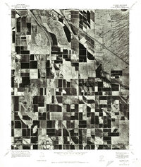
 1971 Casa Grande East1972 Print · USGSCentral Arizona's agricultural landscape is seen in transition during the early seventies as irrigation transforms the desert around Casa Grande. Genealogists and researchers can trace the early city grid and remote features like Lake in the Desert and the high ground of Signal Peak.
 - 1971 Map of Casa Grande West, 1972 Print
 1971 Casa Grande West1972 Print · USGSArizona's desert landscape meets organized agriculture in the early seventies as the desert begins to yield to development. Trace the intersection of the Sacaton Mountains and the expanding irrigation networks near Casa Grande and the Santa Cruz Wash.
 - 1971 Map of Stanfield, 1972 Print
 1971 Stanfield1972 Print · USGSThe agricultural landscape of Pinal County is captured in the early seventies, showing a highly developed grid of desert farm plots. Local historians can trace the early footprint of Stanfield and the natural course of the Santa Cruz Wash across the terrain.
End of results
Showing maps 1-3 of 3
Top cities near Casa Grande
- Maricopa historical maps
- Eloy historical maps
- Coolidge historical maps
- Arizona City historical maps
- Chuichu historical maps
Top neighborhoods of Casa Grande
- Bon historical maps
- Desert Sky Ranch historical maps
- Mission Royale historical maps
- Villago historical maps
- Tamaron historical maps
- Los Portales historical maps
Frequently asked questions
- What are the different types of historical maps available for Casa Grande?
- What is the oldest map of Casa Grande?
- Where can I purchase historical maps of Casa Grande for my home or office?
- Where can I download high-res historical maps of Casa Grande?
- Are there historical topographic maps available for Casa Grande?
- Is there historical aerial imagery available for Casa Grande?
- Where are historical maps of Casa Grande sourced from?