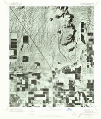
1971 Map of Casa Grande East
USGS Topo · Published 1972About this map
The city of Casa Grande anchors the southwestern corner of this orthophotomosaic, which documents the expansion of irrigation and agriculture across the Pinal County desert in the early 1970s. The landscape transitions from the dense, geometric grid of agricultural fields and orchards in the south to the desert scrub and drainage patterns of the Sacaton Mountains to the north. Water management is a central theme of the terrain, highlighted by the North Branch Santa Cruz Wash cutting through the center and the isolated Lake in the Desert further east. This aerial perspective, captured in July 1971, provides a clear view of the contrast between the developed townsite and the natural elevation of Signal Peak, illustrating the scale of human modification on the arid landscape during a period of significant regional growth.
Find a feature on this map
5 named features on this map. Tap any name to fly to it.
Don’t see what you’re looking for? This feature index may not catch every label — zoom into the map to look around manually.
Map Details
Editions of this 1971 Casa Grande East Map
This is the sole edition of this map. No revisions or reprints were ever made.
Other maps of this area

1907 · Sacaton
USGS Topo · 1:62,500

1914 · Gila Butte
USGS Topo · 1:62,500

1917 · Gila Butte
USGS Topo · 1:62,500

1922 · Casa Grande
USGS Topo · 1:62,500

1922 · Signal Peak
USGS Topo · 1:62,500

1924 · Signal Peak
USGS Topo · 1:62,500

1924 · Casa Grande
USGS Topo · 1:62,500

1952 · Gila Butte SE
USGS Topo · 1:24,000

1952 · Gila Butte
USGS Topo · 1:62,500

1954 · Mesa
USGS Topo · 1:250,000