1940s Maps of Sonoita, Arizona
Explore 6 historic maps of Sonoita from the 1940s. These maps offer a rare glimpse into what life looked like during the 1940s — showing old roads, neighborhoods, homes, and landmarks that have changed or disappeared over time.
Whether you're researching your family's past, planning a metal detecting trip, or studying how Sonoita's landscape evolved across the 1940s, these high-resolution maps are a powerful tool for exploring the history of this region.
- Focus on a specific era: All maps on this page are from the 1940s, giving you a focused view of this time period.
- See what’s changed: Compare century-old streets, trails, and buildings to today's modern landscape using overlays and satellite layers.
- Research with precision: Use these maps for genealogy, historical research, land use analysis, or educational projects.
- View, download, or print: Maps are fully viewable online in high resolution, and can be downloaded or printed for your own records.
Start exploring Sonoita's history through authentic maps from the 1940s. This is your window into the past.
Sonoita, AZ maps
(6)- 1940 Map of Elgin
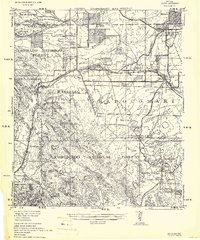 1940 Elgin1940 Print · USGSSoutheastern Arizona ranching country is shown here just before the mid-century, where the Southern Pacific railroad connects remote desert outposts. Researchers can locate early family homesteads like Gardner's Ranch and Rodgers Ranch alongside the historic site of Old Ft. Crittenden.
 - 1947 Map of Elgin, 1953 Print
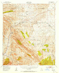 1947 Elgin1953 Print · USGSSanta Cruz and Pima Counties are seen here in the late 1940s as a landscape of sprawling cattle ranches and historic frontier outposts. Genealogists and historians can locate family landmarks like Hacienda Los Encinos alongside the Old Fort Buchanan Ruins and Dunham Mine.2 unique versions available
 - 1948 Map of Elgin, 1953 Print
 1948 Elgin1953 Print · USGSCattle ranching and the railroad defined this corner of Santa Cruz County in the late 1940s. Genealogists and historians can trace family landholdings like Heavner Ranch and Collie Ranch along the Southern Pacific tracks near Elgin.
 - 1948 Map of Sonoita, 1953 Print
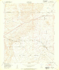
 1948 Sonoita1953 Print · USGSSouthern Arizona ranching and rail life are captured here in the late 1940s, centered on the Sonoita crossroads. Researchers can trace historic family holdings such as Hacienda Los Encinos Ranch and Wilson Ranch, or locate the ruins of Old Fort Crittenden.
 - 1948 Map of O'Donnell Canyon, 1953 Print
 1948 O'Donnell Canyon1953 Print · USGSSanta Cruz County ranching culture and forest management are at the forefront of this late-forties survey. Researchers can trace family-named homesteads like Graham Ranch and Hale Ranch or locate the Canelo Sch and Black Oak Cem.
 - 1948 Map of Mt. Hughes, 1953 Print
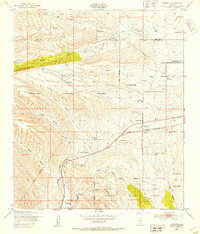
 1948 Mt. Hughes1953 Print · USGSArizona ranching and railroading define this Santa Cruz County landscape in the late 1940s. Genealogists and historians can trace family operations at Harmon Ranch and Turner Ranch or locate the old Southern Pacific siding at Crittenden.
End of results
Showing maps 1-6 of 6
Top cities near Sonoita
Top neighborhoods of Sonoita
Frequently asked questions
- What are the different types of historical maps available for Sonoita?
- What is the oldest map of Sonoita?
- Where can I purchase historical maps of Sonoita for my home or office?
- Where can I download high-res historical maps of Sonoita?
- Are there historical topographic maps available for Sonoita?
- Is there historical aerial imagery available for Sonoita?
- Where are historical maps of Sonoita sourced from?