1990s Maps of Sonoita, Arizona
Explore 6 historic maps of Sonoita from the 1990s. These maps offer a rare glimpse into what life looked like during the 1990s — showing old roads, neighborhoods, homes, and landmarks that have changed or disappeared over time.
Whether you're researching your family's past, planning a metal detecting trip, or studying how Sonoita's landscape evolved across the 1990s, these high-resolution maps are a powerful tool for exploring the history of this region.
- Focus on a specific era: All maps on this page are from the 1990s, giving you a focused view of this time period.
- See what’s changed: Compare century-old streets, trails, and buildings to today's modern landscape using overlays and satellite layers.
- Research with precision: Use these maps for genealogy, historical research, land use analysis, or educational projects.
- View, download, or print: Maps are fully viewable online in high resolution, and can be downloaded or printed for your own records.
Start exploring Sonoita's history through authentic maps from the 1990s. This is your window into the past.
Sonoita, AZ maps
(6)- 1994 Map of Fort Huachuca
 1994 Fort Huachuca1994 Print · USGSSouthern Arizona in the mid-nineties shows a landscape of expansive military reservations, historic land grants, and storied mining districts. Researchers can trace the S P RR through the San Pedro River valley or locate dozens of remote mountain workings like the Montezuma Mine and Eureka Mine.3 unique versions available
 - 1996 Map of Mount Hughes, 2002 Print
 1996 Mount Hughes2002 Print · USGSNear the turn of the millennium, this portion of Santa Cruz County maintains its character as a rugged intersection of ranching and historical mining. Genealogists and researchers can trace the locations of the Crittenden (Site), the Santa Cruz Mine, and family-held lands like Bergier Ranch.2 unique versions available
 - 1996 Map of O'Donnell Canyon, 2002 Print
 1996 O'Donnell Canyon2002 Print · USGSSoutheastern Arizona's ranching and mining heartland is captured here in the mid-1990s, where the high desert meets the Canelo Hills. Researchers can trace family ranch sites like Canelo Hills Ranch, locate the La Plata Mine, and find local landmarks such as the Canelo Ranger Station.
 - 1996 Map of Sonoita, 2002 Print
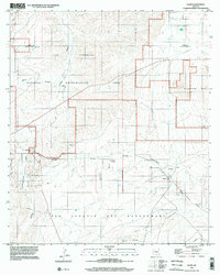
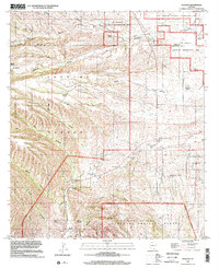 1996 Sonoita2002 Print · USGSSouthern Arizona ranching country and military history converge here in the late twentieth century near the Santa Cruz and Pima county line. Researchers can trace the heritage of the Crown C Ranch and locate the historic Fort Crittenden and Fort Buchanan sites.
 - 1996 Map of Mount Wrightson, 2002 Print
 1996 Mount Wrightson2002 Print · USGSThe Santa Rita Mountains and the high peaks of the Mount Wrightson Wilderness are shown here in the mid-1990s. Researchers can locate numerous historical extraction sites like the Silver King Mine, Wildcat Mine, and Philadelphia Mine tucked into the steep canyons.
 - 1996 Map of Elgin, 2002 Print
 1996 Elgin2002 Print · USGSSouthern Arizona cattle country comes into focus in the mid-1990s as the rail era had faded into the ranching landscape. Genealogists and historians can trace the Old Railroad Grade and locate family burial sites at Fruitland Cemetery or Elgin.
End of results
Showing maps 1-6 of 6
Top cities near Sonoita
Top neighborhoods of Sonoita
Frequently asked questions
- What are the different types of historical maps available for Sonoita?
- What is the oldest map of Sonoita?
- Where can I purchase historical maps of Sonoita for my home or office?
- Where can I download high-res historical maps of Sonoita?
- Are there historical topographic maps available for Sonoita?
- Is there historical aerial imagery available for Sonoita?
- Where are historical maps of Sonoita sourced from?