1930s Maps of Camp Verde, Arizona
Explore 3 historic maps of Camp Verde from the 1930s. These maps offer a rare glimpse into what life looked like during the 1930s — showing old roads, neighborhoods, homes, and landmarks that have changed or disappeared over time.
Whether you're researching your family's past, planning a metal detecting trip, or studying how Camp Verde's landscape evolved across the 1930s, these high-resolution maps are a powerful tool for exploring the history of this region.
- Focus on a specific era: All maps on this page are from the 1930s, giving you a focused view of this time period.
- See what’s changed: Compare century-old streets, trails, and buildings to today's modern landscape using overlays and satellite layers.
- Research with precision: Use these maps for genealogy, historical research, land use analysis, or educational projects.
- View, download, or print: Maps are fully viewable online in high resolution, and can be downloaded or printed for your own records.
Start exploring Camp Verde's history through authentic maps from the 1930s. This is your window into the past.
Camp Verde, AZ maps
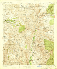
(3)- 1932 Map of Camp Verde, 1959 Print
 1932 Camp Verde1959 Print · USGSThe Verde Valley and the Mogollon Rim are documented here in the early 1930s, showing a landscape of remote cattle ranches and historic ruins. Researchers can trace early schools and homesteads like Red Rock Sch, Middle Verde, and Indian Gardens alongside Montezuma Well.2 unique versions available
 - 1933 Map of Turret Peak
 1933 Turret Peak1933 Print · USGSArizona's central highlands come alive in the 1930s as a land of remote mining claims and isolated ranching outposts. Trace the early copper industry at the Copper Queen Mine and Rosalie Mine, or locate family sites like the Dugan Ranch and Dugas near the Verde River.3 unique versions available
 - 1936 Map of Camp Verde
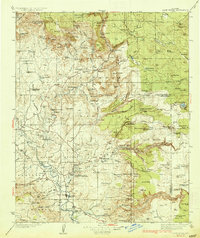 1936 Camp Verde1936 Print · USGSThe Verde Valley and Red Rock country are captured in the mid-1930s, showing a landscape of pioneer ranches and ancient ruins. Researchers can locate the early footprints of Sedona and Camp Verde, alongside remote landmarks like Montezuma Castle National Monument and the Stoneman Lake area.3 unique versions available
End of results
Showing maps 1-3 of 3
Top cities near Camp Verde
Top neighborhoods of Camp Verde
- Camp Verde historical maps
- Middle Verde historical maps
- Mesa Verde Estates historical maps
- Verde River Meadows One historical maps
- Fort River Caves historical maps
- Paradise Acres historical maps
See more
Frequently asked questions
- What are the different types of historical maps available for Camp Verde?
- What is the oldest map of Camp Verde?
- Where can I purchase historical maps of Camp Verde for my home or office?
- Where can I download high-res historical maps of Camp Verde?
- Are there historical topographic maps available for Camp Verde?
- Is there historical aerial imagery available for Camp Verde?
- Where are historical maps of Camp Verde sourced from?