1980s Maps of Camp Verde, Arizona
Explore 2 historic maps of Camp Verde from the 1980s. These maps offer a rare glimpse into what life looked like during the 1980s — showing old roads, neighborhoods, homes, and landmarks that have changed or disappeared over time.
Whether you're researching your family's past, planning a metal detecting trip, or studying how Camp Verde's landscape evolved across the 1980s, these high-resolution maps are a powerful tool for exploring the history of this region.
- Focus on a specific era: All maps on this page are from the 1980s, giving you a focused view of this time period.
- See what’s changed: Compare century-old streets, trails, and buildings to today's modern landscape using overlays and satellite layers.
- Research with precision: Use these maps for genealogy, historical research, land use analysis, or educational projects.
- View, download, or print: Maps are fully viewable online in high resolution, and can be downloaded or printed for your own records.
Start exploring Camp Verde's history through authentic maps from the 1980s. This is your window into the past.
Camp Verde, AZ maps
(2)- 1980 Map of Sedona, 1996 Print
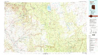 1980 Sedona1996 Print · USGSThe red rock country around Sedona and the Verde Valley are captured in the late twentieth century, showing a mix of ancient sites and modern growth. Genealogists and researchers can trace local landmarks like Cornville, the Camp Verde Indian Reservation, and Montezuma Castle National Monument.
 - 1981 Map of Payson
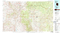 1981 Payson1981 Print · USGSCentral Arizona's mountain country comes into focus in the early eighties, centered on the growing town of Payson. Trace the mining history at Gowan Mine, find old forest outposts like Kohls Ranch, and see the rugged Mogollon Rim terrain.2 unique versions available
End of results
Showing maps 1-2 of 2
Top cities near Camp Verde
Top neighborhoods of Camp Verde
- Camp Verde historical maps
- Middle Verde historical maps
- Mesa Verde Estates historical maps
- Verde River Meadows One historical maps
- Fort River Caves historical maps
- Paradise Acres historical maps
See more
Frequently asked questions
- What are the different types of historical maps available for Camp Verde?
- What is the oldest map of Camp Verde?
- Where can I purchase historical maps of Camp Verde for my home or office?
- Where can I download high-res historical maps of Camp Verde?
- Are there historical topographic maps available for Camp Verde?
- Is there historical aerial imagery available for Camp Verde?
- Where are historical maps of Camp Verde sourced from?