1970s Maps of Calhoun County, Arkansas
Explore 12 historic maps of Calhoun County from the 1970s. These maps offer a rare glimpse into what life looked like during the 1970s — showing old roads, neighborhoods, homes, and landmarks that have changed or disappeared over time.
Whether you're researching your family's past, planning a metal detecting trip, or studying how Calhoun County's landscape evolved across the 1970s, these high-resolution maps are a powerful tool for exploring the history of this region.
- Focus on a specific era: All maps on this page are from the 1970s, giving you a focused view of this time period.
- See what’s changed: Compare century-old streets, trails, and buildings to today's modern landscape using overlays and satellite layers.
- Research with precision: Use these maps for genealogy, historical research, land use analysis, or educational projects.
- View, download, or print: Maps are fully viewable online in high resolution, and can be downloaded or printed for your own records.
Start exploring Calhoun County's history through authentic maps from the 1970s. This is your window into the past.
Calhoun County, AR maps
(12)- 1971 Map of Camden, 1973 Print
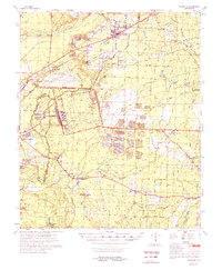
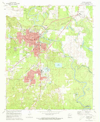 1971 Camden1973 Print · USGSCamden and its riverside suburbs are captured in the early seventies as industrial expansion and timber-hauling railroads defined the local economy. Genealogists can trace family roots at Confederate Cem and Cullendale Cem or locate old neighborhood landmarks like Lincoln High Sch.2 unique versions available
 - 1973 Map of Bearden, 1975 Print
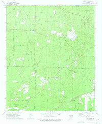
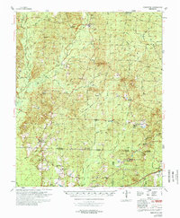
 1973 Bearden1975 Print · USGSBearden and the rural Ouachita County timberlands are caught here during the early seventies, centered on the St Louis Southwestern rail line. Genealogists and local historians can trace old family landmarks like Macedonia Ch, Harlow Cem, and the massive East Camden and Highland Abandoned Ammunition Depot.2 unique versions available
 - 1973 Map of Eagle Mills, 1975 Print
 1973 Eagle Mills1975 Print · USGSOuachita and Calhoun counties appear here in the early seventies during a period of institutional transition. Researchers can trace the massive Abandoned Ammunition Depot alongside local landmarks like Evans Cem, Millville, and Eagle Mills.2 unique versions available
 - 1973 Map of East Camden, 1975 Print
 1973 East Camden1975 Print · USGSSouthern Arkansas in the early seventies shows a landscape shaped by military history and the petroleum industry. Researchers can trace rural lineages through Furr Cem and Plunkett Cem or explore the vast ABANDONED AMMUNITION DEPOT.2 unique versions available
 - 1973 Map of Hampton, 1975 Print
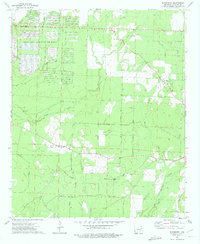
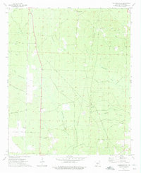
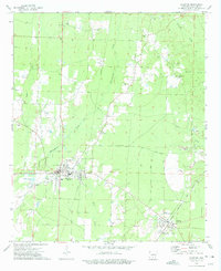 1973 Hampton1975 Print · USGSHampton and the surrounding timberlands of Calhoun County are captured here in the early 1970s as industrial pipelines and gravel extraction shaped the land. Researchers can locate the Rock Island rail line through Harrell and several rural burial sites like Macedonia Cem.2 unique versions available
 - 1973 Map of Woodberry, 1975 Print
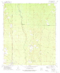
 1973 Woodberry1975 Print · USGSCalhoun County's timberlands and military installations are captured here in the early 1970s. Genealogists can locate family landmarks like Dunn Cem and Paulsina Ch or trace the massive grid of the Abandoned Ammunition Depot.2 unique versions available
 - 1973 Map of Hopeville, 1975 Print
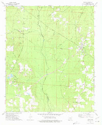
 1973 Hopeville1975 Print · USGSThe borderlands of Dallas, Ouachita, and Calhoun counties are captured here in the early seventies, a landscape of rural crossroads and timbered creek bottoms. Genealogists can locate family landmarks like Stevenson Cem, Oak Grove Ch, and the settlement of Hopeville.2 unique versions available
 - 1973 Map of Tinsman, 1975 Print
 1973 Tinsman1975 Print · USGSThe timberlands and creek bottoms of southern Arkansas come alive in this early 1970s survey of the tri-county borderlands. Researchers can trace the Chicago Rock Island and Pacific rail line and locate landmarks like Williams Cem and the Old Camden Road.2 unique versions available
 - 1973 Map of Banks, 1975 Print
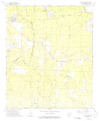
 1973 Banks1975 Print · USGSSouth-central Arkansas appears here during the early seventies, centered on the railroad town of Banks at the county line. Researchers can trace rural lineages through family landmarks like McFarland Cemetery and country churches such as Pleasant Grove Church.2 unique versions available
 - 1973 Map of Chambersville, 1975 Print
 1973 Chambersville1975 Print · USGSCalhoun County's timberlands and rural crossroads are captured here during the mid-seventies, showing the reach of local creek systems and early industrial routes. Genealogists and researchers can locate Calaway Cem, the T & A Tram, and Chambersville.2 unique versions available
 - 1978 Map of Bearden
 1978 Bearden1978 Print · USGSThe Ouachita and Calhoun County borderlands appear here in the late seventies, showing a landscape defined by timber-rail towns and large-scale industrial sites. Researchers can trace family history through sites like Harlow Cem or explore the sprawling grounds of the Abandoned Ammunition Depot.
 - 1978 Map of Princeton
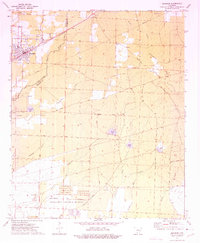
 1978 Princeton1978 Print · USGSSouth Arkansas rural life is captured here in the late 1970s as timber and rail lines defined the local economy. Researchers can trace family roots at Princeton Cem and Macedonia Ch or locate industrial sites like the Fish Hatchery and numerous Gravel Pits.
End of results
Showing maps 1-12 of 12
Top cities of Calhoun County
Frequently asked questions
- What are the different types of historical maps available for Calhoun County?
- What is the oldest map of Calhoun County?
- Where can I purchase historical maps of Calhoun County for my home or office?
- Where can I download high-res historical maps of Calhoun County?
- Are there historical topographic maps available for Calhoun County?
- Is there historical aerial imagery available for Calhoun County?
- Where are historical maps of Calhoun County sourced from?