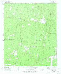
1973 Map of Hopeville
USGS Topo · Published 1975About this map
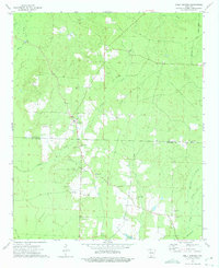
Hopeville sits at the center of this rural South Arkansas landscape, where Dallas, Ouachita, and Calhoun counties meet along the upper reaches of the Ouachita River basin. In the early 1970s, the region was defined by its network of winding creeks and dispersed community centers. The St Louis Southwestern railroad cuts through the southeastern corner, serving the town of Thornton. The map reveals a high density of country churches and family cemeteries, such as Oak Grove Ch, Temperance Hill Ch, and the McDonald Cem, suggesting a long-established pattern of rural settlement. Waterways like Champagnolle Creek and Beaver Pond Creek drain the wooded terrain, while specialized land uses appear at the Fish Hatchery and several local Gravel Pits, reflecting the area's natural resource-based economy during this era.
Find a feature on this map
37 named features on this map. Tap any name to fly to it.
Don’t see what you’re looking for? This feature index may not catch every label — zoom into the map to look around manually.
Map Details
Editions of this 1973 Hopeville Map
2 editions found
Other maps of this area

1903 · Camden
USGS Topo · 1:125,000

1953 · El Dorado
USGS Topo · 1:250,000

1957 · El Dorado
USGS Topo · 1:250,000

1958 · El Dorado
USGS Topo · 1:250,000

1960 · El Dorado
USGS Topo · 1:250,000

1966 · Fordyce
USGS Topo · 1:24,000
1969 · Ivan
USGS Topo · 1:24,000

1973 · Bearden
USGS Topo · 1:24,000
1973 · Eagle Mills
USGS Topo · 1:24,000
1973 · Holly Springs
USGS Topo · 1:24,000