1940s Maps of Independence County, Arkansas
Explore 11 historic maps of Independence County from the 1940s. These maps offer a rare glimpse into what life looked like during the 1940s — showing old roads, neighborhoods, homes, and landmarks that have changed or disappeared over time.
Whether you're researching your family's past, planning a metal detecting trip, or studying how Independence County's landscape evolved across the 1940s, these high-resolution maps are a powerful tool for exploring the history of this region.
- Focus on a specific era: All maps on this page are from the 1940s, giving you a focused view of this time period.
- See what’s changed: Compare century-old streets, trails, and buildings to today's modern landscape using overlays and satellite layers.
- Research with precision: Use these maps for genealogy, historical research, land use analysis, or educational projects.
- View, download, or print: Maps are fully viewable online in high resolution, and can be downloaded or printed for your own records.
Start exploring Independence County's history through authentic maps from the 1940s. This is your window into the past.
Independence County, AR maps
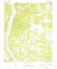
(11)- 1941 Map of Strawberry, 1946 Print
 1941 Strawberry1946 Print · USGSThe rural river valleys of northeast Arkansas are shown here during the early 1940s, highlighting a landscape of small schools and post offices. Genealogists can trace family roots through landmarks like Saffell Post Office, Buck Cem, and Harmony Sch.
 - 1942 Map of Bethesda
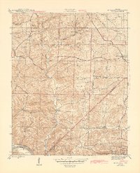
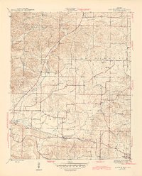
 1942 Bethesda1942 Print · USGSIndependence County during the early 1940s reveals a landscape of ridge-top farms and river-bottom commerce. Genealogists can trace family roots through local landmarks like Gill Cem, O'Neal Sch, and the riverside crossing at Walls Ferry.4 unique versions available
 - 1942 Map of Jamestown, 1945 Print
 1942 Jamestown1945 Print · USGSIndependence County during the 1940s was a landscape of river-bottom farms and upland ridges shaped by the White River. Researchers can locate rural landmarks like the Enon Powell Sch, Alderbrook Cem, and the historic Cherokee Boundary.3 unique versions available
 - 1942 Map of Almond, 1945 Print
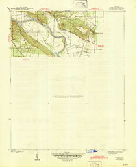
 1942 Almond1945 Print · USGSThe river-and-rail corridor along the White River defines this 1940s landscape where Independence and Cleburne Counties meet. Genealogists and historians can trace old transit points like Earnhearts Ferry and the Old Cherokee Line boundary.3 unique versions available
 - 1942 Map of Salado, 1945 Print
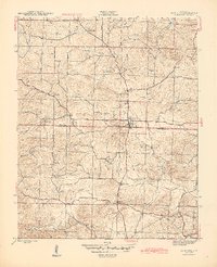
 1942 Salado1945 Print · USGSIndependence County along the White River remained a landscape of river-bend settlements and prominent ridges during the 1940s. Genealogists and local historians can trace family landmarks like Montgomery Sprs, Pine Mtn, and the pass at Mountain Gap.2 unique versions available
 - 1942 Map of Batesville, 1945 Print
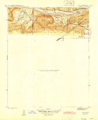
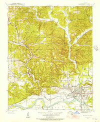
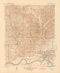 1942 Batesville1945 Print · USGSBatesville and its riverfront industry are captured here during the 1940s as a vital hub for rail and river transport. Genealogists and historians can trace the foundations of Independence County through local landmarks like the Aydelotte Mine, Big Spring Mill, and Pleasant Valley Cemeteries.2 unique versions available
 - 1942 Map of Mt Pleasant, 1945 Print
 1942 Mt Pleasant1945 Print · USGSIzard County in the 1940s was a landscape of deep hollows and active mining operations near the Independence County line. Genealogists and historians can trace rural family legacies through local landmarks like Gid Sch, Mt Lebanon Ch, and the Barren Fork Cem.5 unique versions available
 - 1943 Map of Sandtown
 1943 Sandtown1943 Print · USGSThe rural uplands of Independence and Sharp Counties come into focus during the early 1940s, revealing a landscape of remote mines and creek-side settlements. Researchers can trace historic family-named landmarks such as Polk Southard Mines, Martins Store, and Wolf Sch.4 unique versions available
 - 1943 Map of Cave City, 1945 Print
 1943 Cave City1945 Print · USGSCave City and its surrounding hill country are captured in the 1940s at the intersection of Sharp and Independence counties. Researchers can trace rural lineages through local landmarks like Hickory Valley, Cotton Hill Ch, and the Maxville Sch.5 unique versions available
 - 1943 Map of Sulphur Rock, 1945 Print
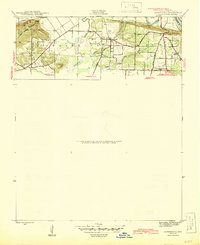
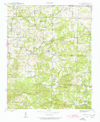
 1943 Sulphur Rock1945 Print · USGSIndependence County during the mid-forties reveals a rural landscape defined by the Missouri Pacific rail line and numerous community crossroads. Genealogists and local historians can trace family roots at Rehoboth Cem, locate the old County Farm, or identify vanished school sites like New Hope Sch and Brewer Sch.6 unique versions available
 - 1943 Map of Batesville, 1956 Print
 1943 Batesville1956 Print · USGSBatesville and the White River valley were bustling hubs of rail and river commerce during the early 1940s. Genealogists and historians can trace old landmarks like the Masonic Home, family burial sites at Pleasant Valley Cemeteries, and industrial works like the Gibson Mine.4 unique versions available
End of results
Showing maps 1-11 of 11
Top cities of Independence County
- Batesville historical maps
- Southside historical maps
- Newark historical maps
- Cushman historical maps
- Sulphur Rock historical maps
- Pleasant Plains historical maps
See more
Frequently asked questions
- What are the different types of historical maps available for Independence County?
- What is the oldest map of Independence County?
- Where can I purchase historical maps of Independence County for my home or office?
- Where can I download high-res historical maps of Independence County?
- Are there historical topographic maps available for Independence County?
- Is there historical aerial imagery available for Independence County?
- Where are historical maps of Independence County sourced from?