1950s Maps of Independence County, Arkansas
Explore 6 historic maps of Independence County from the 1950s. These maps offer a rare glimpse into what life looked like during the 1950s — showing old roads, neighborhoods, homes, and landmarks that have changed or disappeared over time.
Whether you're researching your family's past, planning a metal detecting trip, or studying how Independence County's landscape evolved across the 1950s, these high-resolution maps are a powerful tool for exploring the history of this region.
- Focus on a specific era: All maps on this page are from the 1950s, giving you a focused view of this time period.
- See what’s changed: Compare century-old streets, trails, and buildings to today's modern landscape using overlays and satellite layers.
- Research with precision: Use these maps for genealogy, historical research, land use analysis, or educational projects.
- View, download, or print: Maps are fully viewable online in high resolution, and can be downloaded or printed for your own records.
Start exploring Independence County's history through authentic maps from the 1950s. This is your window into the past.
Independence County, AR maps
(6)- 1953 Map of Memphis, 1966 Print
 1953 Memphis1966 Print · USGSEastern Arkansas and the Memphis riverfront are shown here during the mid-century period of regional growth and river management. Local historians can trace the paths of the Chicago Rock Island & Pacific RR through Forrest City or locate river landmarks like President's Island.3 unique versions available
 - 1954 Map of Charlotte, 1955 Print
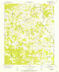
 1954 Charlotte1955 Print · USGSMid-century Independence County comes alive in this 1950s survey of the river valleys and upland farms. Genealogists and local historians can locate numerous rural landmarks such as Antioch Ch, Convenience Cem, and the settlement of Charlotte.2 unique versions available
 - 1955 Map of Strawberry, 1956 Print
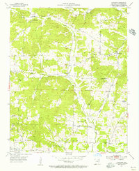
 1955 Strawberry1956 Print · USGSThe Arkansas Ozark foothills come alive in the mid-fifties, centered on the Strawberry settlement and its rural surrounds. Genealogists can trace a wealth of family history through local landmarks like Willmuth Cem, Mt Zion Ch, and Saffell.2 unique versions available
 - 1955 Map of Cord, 1956 Print
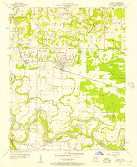
 1955 Cord1956 Print · USGSIndependence and Jackson counties are shown in the mid-fifties, dominated by the winding path of the Black River. Genealogists and local historians can trace rural family sites near Stone Ch, Happy Cem, and the settlement of Cord.3 unique versions available
 - 1956 Map of Memphis
 1956 Memphis1956 Print · USGSThe Mississippi Delta and the bluffs of West Tennessee meet in the mid-fifties, showing a landscape defined by massive river systems and rail hubs. Researchers can trace the path of Crowleys Ridge or locate vanished river landings near Centennial Island and Island No 35.
 - 1956 Map of Newark, 1957 Print
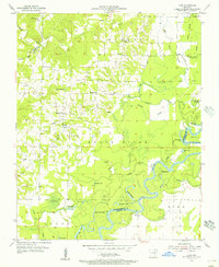
 1956 Newark1957 Print · USGSThe bottomlands of Independence County are shown in detail during the mid-fifties, dominated by the winding loops of the White River. Genealogists and historians can trace numerous family-named landmarks and rural cemeteries such as Akron Cem, Blue Springs Cem, and the Oil Trough Ferry.
End of results
Showing maps 1-6 of 6
Top cities of Independence County
- Batesville historical maps
- Southside historical maps
- Newark historical maps
- Cushman historical maps
- Sulphur Rock historical maps
- Pleasant Plains historical maps
See more
Frequently asked questions
- What are the different types of historical maps available for Independence County?
- What is the oldest map of Independence County?
- Where can I purchase historical maps of Independence County for my home or office?
- Where can I download high-res historical maps of Independence County?
- Are there historical topographic maps available for Independence County?
- Is there historical aerial imagery available for Independence County?
- Where are historical maps of Independence County sourced from?