1970s Maps of Independence County, Arkansas
Explore 2 historic maps of Independence County from the 1970s. These maps offer a rare glimpse into what life looked like during the 1970s — showing old roads, neighborhoods, homes, and landmarks that have changed or disappeared over time.
Whether you're researching your family's past, planning a metal detecting trip, or studying how Independence County's landscape evolved across the 1970s, these high-resolution maps are a powerful tool for exploring the history of this region.
- Focus on a specific era: All maps on this page are from the 1970s, giving you a focused view of this time period.
- See what’s changed: Compare century-old streets, trails, and buildings to today's modern landscape using overlays and satellite layers.
- Research with precision: Use these maps for genealogy, historical research, land use analysis, or educational projects.
- View, download, or print: Maps are fully viewable online in high resolution, and can be downloaded or printed for your own records.
Start exploring Independence County's history through authentic maps from the 1970s. This is your window into the past.
Independence County, AR maps
(2)- 1973 Map of Floral, 1975 Print
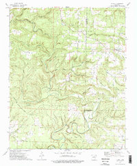 1973 Floral1975 Print · USGSThe rural uplands of Independence County are shown in the early seventies, centered on the community of Floral. Genealogists and local historians can trace family ties through several remote burial grounds and churches, including Warren Cem, Mason Cem, and Harris Chapel.2 unique versions available
 - 1973 Map of Concord, 1975 Print
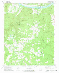 1973 Concord1975 Print · USGSNorth central Arkansas highlands meet the river valley in the 1970s, as small mountain communities like Concord and Almond grew near the Indian Treaty Boundary. Genealogists can locate family landmarks such as Bellmore Cem and Banner Ch tucked between the ridges and river sloughs.
End of results
Showing maps 1-2 of 2
Top cities of Independence County
- Batesville historical maps
- Southside historical maps
- Newark historical maps
- Cushman historical maps
- Sulphur Rock historical maps
- Pleasant Plains historical maps
See more
Frequently asked questions
- What are the different types of historical maps available for Independence County?
- What is the oldest map of Independence County?
- Where can I purchase historical maps of Independence County for my home or office?
- Where can I download high-res historical maps of Independence County?
- Are there historical topographic maps available for Independence County?
- Is there historical aerial imagery available for Independence County?
- Where are historical maps of Independence County sourced from?