1980s Maps of Independence County, Arkansas
Explore 9 historic maps of Independence County from the 1980s. These maps offer a rare glimpse into what life looked like during the 1980s — showing old roads, neighborhoods, homes, and landmarks that have changed or disappeared over time.
Whether you're researching your family's past, planning a metal detecting trip, or studying how Independence County's landscape evolved across the 1980s, these high-resolution maps are a powerful tool for exploring the history of this region.
- Focus on a specific era: All maps on this page are from the 1980s, giving you a focused view of this time period.
- See what’s changed: Compare century-old streets, trails, and buildings to today's modern landscape using overlays and satellite layers.
- Research with precision: Use these maps for genealogy, historical research, land use analysis, or educational projects.
- View, download, or print: Maps are fully viewable online in high resolution, and can be downloaded or printed for your own records.
Start exploring Independence County's history through authentic maps from the 1980s. This is your window into the past.
Independence County, AR maps
(9)- 1980 Map of Strangers Home
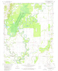 1980 Strangers Home1980 Print · USGSThe Black River lowlands of northeast Arkansas are shown here in the late twentieth century, where river bends meet managed wetlands. Family historians can locate several rural burial grounds including Pleasant Hill Cem and Ruffner Cem near the settlement of Strangers Home.
 - 1980 Map of Swifton West
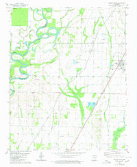 1980 Swifton West1980 Print · USGSThe Black River bottoms in Jackson and Independence counties are captured here in the early eighties. Genealogists can locate family burial grounds like Harrison Cem and Bandy Cem or trace the Missouri Pacific rail line through Swifton.
 - 1986 Map of Batesville
 1986 Batesville1986 Print · USGSNorth-central Arkansas in the mid-eighties shows a landscape of river-bend towns and Ozark foothills during a period of steady growth. You can trace family roots through numerous upland sites like Hickory Valley School, Sandtown Hill Cem, and the riverfront at Oil Trough.2 unique versions available
 - 1989 Map of Bethesda
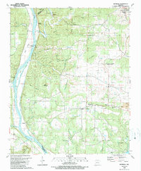 1989 Bethesda1989 Print · USGSIn the late 1980s, the rural hills of Independence County remained a landscape of tight-knit communities and river-fed industry. Researchers can trace the roots of local families at Bethesda, locate historical congregations like Chinquapin Ch, and find the river-side Biltmore Siding.
 - 1989 Map of Batesville
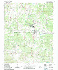
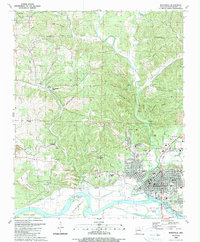 1989 Batesville1989 Print · USGSBatesville and its rugged river valley surroundings are captured in the late eighties as a bustling center of education and industry. Researchers can find numerous family cemeteries like Greenfield Cem, local landmarks like Big Spring Mill, and the riverside campus of Arkansas College.
 - 1989 Map of Mount Pleasant
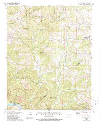 1989 Mount Pleasant1989 Print · USGSThe hill country of Izard and Independence counties comes into focus in the late eighties, documenting the rural settlements and caves north of the White River. Genealogists can locate several remote burial grounds like No Bottom Cem and Winkle Cem, alongside community landmarks such as Macedonia Ch.
 - 1989 Map of Cave City, 1990 Print
 1989 Cave City1990 Print · USGSCrossing the Sharp and Independence county lines in the late 1980s, this area centers on the growth of Cave City and its surrounding rural townships. Researchers can trace family history through numerous remote sites like Hickory Valley Cem, Gray Chapel Cem, and Maxville.
 - 1989 Map of Sandtown, 1990 Print
 1989 Sandtown1990 Print · USGSThe hill country of North-Central Arkansas is captured here in the late 1980s, where three counties meet among deep hollows and creek branches. Genealogists and local historians can trace family roots through numerous remote sites like Mt Carmel Cem, St Pauls Ch, and the settlement of Sandtown.
 - 1989 Map of Sulphur Rock, 1990 Print
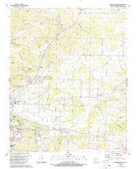 1989 Sulphur Rock1990 Print · USGSIndependence County's landscape east of Batesville shows a unique mix of mid-century infrastructure and pioneer-era roots in the late 1980s. Genealogists and historians can trace numerous family cemeteries like Harvison Cem and landmarks such as the Old RR Gr or Arkansas College.
End of results
Showing maps 1-9 of 9
Top cities of Independence County
- Batesville historical maps
- Southside historical maps
- Newark historical maps
- Cushman historical maps
- Sulphur Rock historical maps
- Pleasant Plains historical maps
See more
Frequently asked questions
- What are the different types of historical maps available for Independence County?
- What is the oldest map of Independence County?
- Where can I purchase historical maps of Independence County for my home or office?
- Where can I download high-res historical maps of Independence County?
- Are there historical topographic maps available for Independence County?
- Is there historical aerial imagery available for Independence County?
- Where are historical maps of Independence County sourced from?