1960s Maps of Independence County, Arkansas
Explore 11 historic maps of Independence County from the 1960s. These maps offer a rare glimpse into what life looked like during the 1960s — showing old roads, neighborhoods, homes, and landmarks that have changed or disappeared over time.
Whether you're researching your family's past, planning a metal detecting trip, or studying how Independence County's landscape evolved across the 1960s, these high-resolution maps are a powerful tool for exploring the history of this region.
- Focus on a specific era: All maps on this page are from the 1960s, giving you a focused view of this time period.
- See what’s changed: Compare century-old streets, trails, and buildings to today's modern landscape using overlays and satellite layers.
- Research with precision: Use these maps for genealogy, historical research, land use analysis, or educational projects.
- View, download, or print: Maps are fully viewable online in high resolution, and can be downloaded or printed for your own records.
Start exploring Independence County's history through authentic maps from the 1960s. This is your window into the past.
Independence County, AR maps
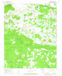
(11)- 1961 Map of Grange, 1963 Print
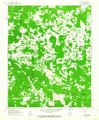 1961 Grange1963 Print · USGSThe foothills of the Arkansas Ozarks are captured here in the early sixties, showing the rural communities of Sharp and Independence counties. Researchers can trace dozens of local family sites and landmarks including Shelbyville, Grange, and the Charlotte Lookout Tower.2 unique versions available
 - 1962 Map of Jacksonport, 1963 Print
 1962 Jacksonport1963 Print · USGSThe confluence of the Black and White Rivers in the early 1960s highlights a landscape of oxbows and riverfront history. Researchers can locate numerous family cemeteries such as Holloway Cem and Mercy Seat Cem, or trace the MISSOURI PACIFIC line through Campbell Station.3 unique versions available
 - 1962 Map of Newark, 1963 Print
 1962 Newark1963 Print · USGSThe Independence County river valley comes into sharp focus during the early 1960s, showing the interaction between the White River and local rail towns. Genealogists can trace family roots through numerous sites like Akron Cem, Oil Trough Ferry, and Oak Grove Ch.3 unique versions available
 - 1962 Map of Olyphant, 1963 Print
 1962 Olyphant1963 Print · USGSIndependence and Jackson counties are captured here in the early sixties as the rail-side community of Olyphant and rural settlements like Thida anchored the landscape. Genealogists can trace family names at Lone Beech Cem and Sanders Cem or locate the local Blackland Chapel.2 unique versions available
 - 1962 Map of Newport, 1963 Print
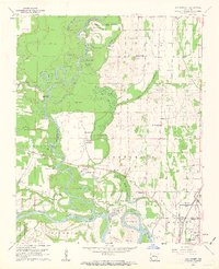
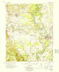
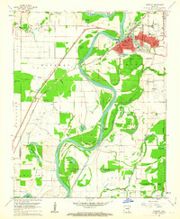 1962 Newport1963 Print · USGSJackson and Independence counties are captured here in the early sixties, centered on the riverfront development of Newport. Researchers can trace local genealogy and rural life through landmarks like Nuckles Switch Cem, Castleberry Sch, and the abandoned airport.3 unique versions available
 - 1962 Map of Newport, 1967 Print
 1962 Newport1967 Print · USGSThe Arkansas Delta comes to life in the early sixties, showing the river-dominated landscape of Jackson and Independence Counties. Researchers can trace family sites at Elgin Landmark Ch or follow the Missouri Pacific rails through Oil Trough and Newport.
 - 1965 Map of Salado, 1966 Print
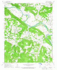 1965 Salado1966 Print · USGSIndependence County in the mid-1960s is shown here as a landscape of river-bottom farms and upland timber before major modern development. Researchers can locate family landmarks such as Swaims Chapel, the Egner Cem, and the path of the Old River Road.2 unique versions available
 - 1965 Map of Pleasant Plains, 1966 Print
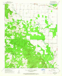
 1965 Pleasant Plains1966 Print · USGSThe Independence and White County border comes to life in the mid-sixties, showing the rural networks connecting Pleasant Plains and Roosevelt. Researchers can trace old family sites near New Bethel Ch, Union Grove Cem, or the camps along Salado Creek.2 unique versions available
 - 1965 Map of Jamestown, 1966 Print
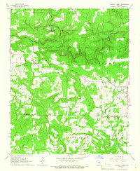
 1965 Jamestown1966 Print · USGSIndependence County in the mid-1960s reveals a landscape of upland ridges and river islands as the region balanced rural life with industrial quarrying. Researchers can locate family landmarks like Palestine Cem, the historic Indian Treaty Boundary, and the community centers of Jamestown and Locust Grove.2 unique versions available
 - 1965 Map of Huff, 1966 Print
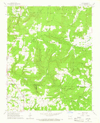 1965 Huff1966 Print · USGSThe rural interior of northern Arkansas comes into focus in the mid-1960s as these hillsides transitioned from traditional farming toward modern infrastructure. Genealogists and historians can trace family locations near Huff Cem, Midway, and Sunnyside Ch.2 unique versions available
 - 1966 Map of Newport
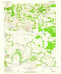
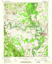
 1966 Newport1966 Print · USGSThe White River meanders through Jackson and Independence counties in the mid-sixties, revealing a network of river-bend settlements and rail hubs. Researchers can trace historic church sites like Mt Zion Ch, family cemeteries such as Salem Cem, and the industrial pulse of Newport and Newark.
End of results
Showing maps 1-11 of 11
Top cities of Independence County
- Batesville historical maps
- Southside historical maps
- Newark historical maps
- Cushman historical maps
- Sulphur Rock historical maps
- Pleasant Plains historical maps
See more
Frequently asked questions
- What are the different types of historical maps available for Independence County?
- What is the oldest map of Independence County?
- Where can I purchase historical maps of Independence County for my home or office?
- Where can I download high-res historical maps of Independence County?
- Are there historical topographic maps available for Independence County?
- Is there historical aerial imagery available for Independence County?
- Where are historical maps of Independence County sourced from?