1970s Maps of Logan County, Arkansas
Explore 5 historic maps of Logan County from the 1970s. These maps offer a rare glimpse into what life looked like during the 1970s — showing old roads, neighborhoods, homes, and landmarks that have changed or disappeared over time.
Whether you're researching your family's past, planning a metal detecting trip, or studying how Logan County's landscape evolved across the 1970s, these high-resolution maps are a powerful tool for exploring the history of this region.
- Focus on a specific era: All maps on this page are from the 1970s, giving you a focused view of this time period.
- See what’s changed: Compare century-old streets, trails, and buildings to today's modern landscape using overlays and satellite layers.
- Research with precision: Use these maps for genealogy, historical research, land use analysis, or educational projects.
- View, download, or print: Maps are fully viewable online in high resolution, and can be downloaded or printed for your own records.
Start exploring Logan County's history through authentic maps from the 1970s. This is your window into the past.
Logan County, AR maps
(5)- 1972 Map of Chickalah Mountain West, 1974 Print
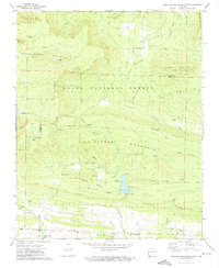 1972 Chickalah Mountain West1974 Print · USGSThe northern Arkansas wilderness in the early seventies shows a landscape of timber, small settlements, and ridge-top lookouts. Local researchers can trace rural community life through landmarks like Hickory Grove, Stafford Cem, and the Spring Lake recreation area.2 unique versions available
 - 1972 Map of Chickalah Mountain East, 1974 Print
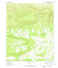 1972 Chickalah Mountain East1974 Print · USGSThe rural valleys and timbered plateaus of Yell County come to life in this early 1970s survey. Genealogists and local historians can trace family locations near Chickalah, Sulphur Springs, and Hale Cem, or locate landmarks like Robinson Point Ch and Mountain Spring Cem.2 unique versions available
 - 1977 Map of Russellville
 1977 Russellville1977 Print · USGSThe Arkansas River Valley and surrounding Ozark Mountains are documented here during a period of significant postwar growth and infrastructure development. Genealogists and researchers can locate family landmarks such as Mount Carmel Cem, St Josephs Church, and several remote Coal Mine sites along the Missouri Pacific RR line.
 - 1978 Map of Fort Smith, 1979 Print
 1978 Fort Smith1979 Print · USGSThe Arkansas-Oklahoma borderlands in the late seventies show a landscape shaped by massive river reservoirs and sprawling military reservations. Trace the historic rail lines of the Missouri Pacific RR and locate regional landmarks like Fort Gibson, Tenkiller Ferry Lake, and Barling.2 unique versions available
 - 1978 Map of Fort Smith, 1979 Print
 1978 Fort Smith1979 Print · USGSThe Arkansas-Oklahoma borderlands in the late seventies show a region defined by river navigation, coal mining, and military expansion. You can trace industrial footprints like the Strip Mines and the vast Fort Chaffee Military Reservation.2 unique versions available
End of results
Showing maps 1-5 of 5
Top cities of Logan County
- Booneville historical maps
- Paris historical maps
- Magazine historical maps
- Subiaco historical maps
- Caulksville historical maps
- Scranton historical maps
See more
Frequently asked questions
- What are the different types of historical maps available for Logan County?
- What is the oldest map of Logan County?
- Where can I purchase historical maps of Logan County for my home or office?
- Where can I download high-res historical maps of Logan County?
- Are there historical topographic maps available for Logan County?
- Is there historical aerial imagery available for Logan County?
- Where are historical maps of Logan County sourced from?