1990s Maps of Logan County, Arkansas
Explore 12 historic maps of Logan County from the 1990s. These maps offer a rare glimpse into what life looked like during the 1990s — showing old roads, neighborhoods, homes, and landmarks that have changed or disappeared over time.
Whether you're researching your family's past, planning a metal detecting trip, or studying how Logan County's landscape evolved across the 1990s, these high-resolution maps are a powerful tool for exploring the history of this region.
- Focus on a specific era: All maps on this page are from the 1990s, giving you a focused view of this time period.
- See what’s changed: Compare century-old streets, trails, and buildings to today's modern landscape using overlays and satellite layers.
- Research with precision: Use these maps for genealogy, historical research, land use analysis, or educational projects.
- View, download, or print: Maps are fully viewable online in high resolution, and can be downloaded or printed for your own records.
Start exploring Logan County's history through authentic maps from the 1990s. This is your window into the past.
Logan County, AR maps
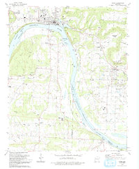
(12)- 1992 Map of Russellville, 1993 Print
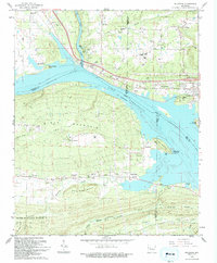
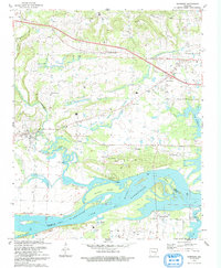
 1992 Russellville1993 Print · USGSCentral Arkansas in the early nineties shows a landscape defined by the Arkansas River valley and the surrounding national forests. Trace the development of river towns like Russellville and Dardanelle alongside landmarks such as Lake Dardanelle and Magazine Mtn.
 - 1993 Map of Delaware
 1993 Delaware1993 Print · USGSThe Arkansas River valley near the Ozark foothills comes into focus in the early nineties, showing a landscape defined by the expansive Lake Dardanelle. Genealogists and researchers can trace an Old Railroad Grade and locate numerous family burial sites like Hon Cem and Garrison Cem.
 - 1993 Map of Coal Hill
 1993 Coal Hill1993 Print · USGSCoal Hill and the Arkansas River valley are shown in the early nineties as the region balanced its coal mining heritage with the waters of Lake Dardanelle. Genealogists can locate numerous family burial sites like Huddleston Cem and Burnett Cem near the Strip Mine workings.
 - 1993 Map of Clarksville
 1993 Clarksville1993 Print · USGSJohnson County during the early nineties shows the expansion of Clarksville alongside the Arkansas River-Lake Dardanelle. Family historians can locate several rural burial grounds like Macedonia Cem and Pryor Cem, or trace the path of the Missouri Pacific rail line.
 - 1993 Map of Paris
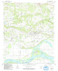
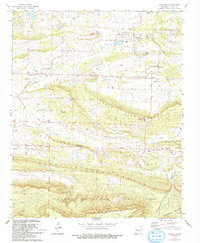
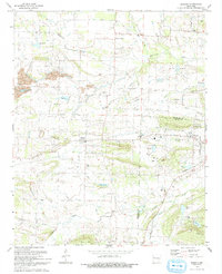
 1993 Paris1993 Print · USGSLogan County during the early nineties shows a landscape defined by coal mining and monastic tradition. Researchers can trace the legacy of the Paris Gas Field and family history at McKendree Ch Cem, Hixson Cem, and Union Ch.
 - 1993 Map of Ozark
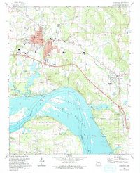
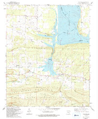
 1993 Ozark1993 Print · USGSThe riverfront town of Ozark and the surrounding Arkansas River valley are shown in the early nineties, centered on the engineering of the Ozark-Jeta Taylor Lock and Dam. Researchers can trace rural lineages through sites like Pilot Grove Cem, St Marys Ch, and the town of Denning.
 - 1993 Map of Scranton
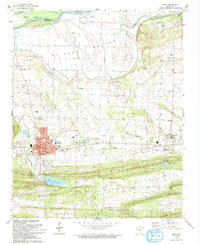
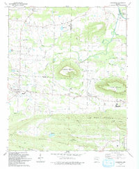
 1993 Scranton1993 Print · USGSThe rural landscapes of Logan County are captured here in the early nineties, showing the organized settlements of Scranton and Prairie View amidst a series of prominent ridges. Genealogists can locate numerous burial sites like Saint Meinrads Cem and trace the path of an Old Railroad Grade.
 - 1993 Map of New Blaine
 1993 New Blaine1993 Print · USGSLogan County and the Arkansas River valley are shown here in the early nineties as the region balanced forest conservation with lakeside recreation. Genealogists can locate several family landmarks including Frietsche Cem and Hall Cem, or trace the path of the Old Railroad Grade.
 - 1993 Map of Caulksville
 1993 Caulksville1993 Print · USGSLogan and Franklin counties are shown here in the early nineties, centered on the distinctive peak of Horseshoe Mountain. Researchers can trace the Old Railroad Grade and locate historic sites like Little Flock Ch, Carbon City, and McVay Cem.
 - 1993 Map of Hartman
 1993 Hartman1993 Print · USGSThe northern banks of the Arkansas River and Lake Dardanelle are captured here in the early 1990s. Researchers can trace the river economy and local genealogy through landmarks like Skaggs Island, Morrison Bluff, and the Union Grove Ch.
 - 1993 Map of Branch
 1993 Branch1993 Print · USGSThe Franklin and Logan County border comes to life in this early nineties survey of the Arkansas countryside. Genealogists and local historians can trace family roots through landmarks like County Line High Sch, Moffett Cem, and the rural settlement at Peter Pender.
 - 1997 Map of Barber, 1999 Print
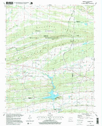 1997 Barber1999 Print · USGSSebastian and Logan counties are shown in the late 1990s as the landscape transitions from the ridges of Fort Chaffee Military Reservation to Booneville Lake. Researchers can trace the Old Railroad Grade and locate historic burial sites like Washburn Cem and Spencer Cem.
End of results
Showing maps 1-12 of 12
Top cities of Logan County
- Booneville historical maps
- Paris historical maps
- Magazine historical maps
- Subiaco historical maps
- Caulksville historical maps
- Scranton historical maps
See more
Frequently asked questions
- What are the different types of historical maps available for Logan County?
- What is the oldest map of Logan County?
- Where can I purchase historical maps of Logan County for my home or office?
- Where can I download high-res historical maps of Logan County?
- Are there historical topographic maps available for Logan County?
- Is there historical aerial imagery available for Logan County?
- Where are historical maps of Logan County sourced from?