1950s Maps of Logan County, Arkansas
Explore 4 historic maps of Logan County from the 1950s. These maps offer a rare glimpse into what life looked like during the 1950s — showing old roads, neighborhoods, homes, and landmarks that have changed or disappeared over time.
Whether you're researching your family's past, planning a metal detecting trip, or studying how Logan County's landscape evolved across the 1950s, these high-resolution maps are a powerful tool for exploring the history of this region.
- Focus on a specific era: All maps on this page are from the 1950s, giving you a focused view of this time period.
- See what’s changed: Compare century-old streets, trails, and buildings to today's modern landscape using overlays and satellite layers.
- Research with precision: Use these maps for genealogy, historical research, land use analysis, or educational projects.
- View, download, or print: Maps are fully viewable online in high resolution, and can be downloaded or printed for your own records.
Start exploring Logan County's history through authentic maps from the 1950s. This is your window into the past.
Logan County, AR maps
(4)- 1951 Map of Ione
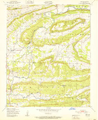 1951 Ione1951 Print · USGSLogan and Scott Counties appear at the start of the 1950s, showing a landscape defined by the winding Petit Jean Creek and the southern Ouachita National Forest. Researchers can locate old community hubs like Ione, Elm Park, and the French Prairie Cemetery.2 unique versions available
 - 1951 Map of Burnville
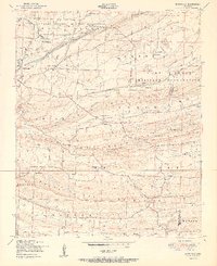 1951 Burnville1951 Print · USGSSebastian and Logan counties appear in the early fifties as the military presence at Camp Chaffee met the rural life of Burnville. Genealogists can trace early homesteads and landmarks like Liberty Church, Milltown, and the Burnville School.2 unique versions available
 - 1951 Map of Barber
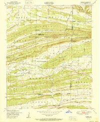 1951 Barber1951 Print · USGSThe Arkansas Ozark foothills meet military history in the early fifties, where the Camp Chaffee Military Reservation borders rural communities. Genealogists can locate family landmarks like Spencer Cemetery, Mebane Cemetery, and the small settlement of Barber.2 unique versions available
 - 1956 Map of Russellville
 1956 Russellville1956 Print · USGSThe Arkansas River valley and the surrounding Boston Mountains are captured here in the mid-fifties, showing a landscape of small timber towns and new reservoirs. Genealogists can trace family roots through upland settlements like Pelsor and Witts Springs or locate the campus of Arkansas Polytechnic College.2 unique versions available
End of results
Showing maps 1-4 of 4
Top cities of Logan County
- Booneville historical maps
- Paris historical maps
- Magazine historical maps
- Subiaco historical maps
- Caulksville historical maps
- Scranton historical maps
See more
Frequently asked questions
- What are the different types of historical maps available for Logan County?
- What is the oldest map of Logan County?
- Where can I purchase historical maps of Logan County for my home or office?
- Where can I download high-res historical maps of Logan County?
- Are there historical topographic maps available for Logan County?
- Is there historical aerial imagery available for Logan County?
- Where are historical maps of Logan County sourced from?