1900s (20th Century) Maps of Logan County, Arkansas
Explore 57 historic maps of Logan County from the 1900s (20th Century). These maps offer a rare glimpse into what life looked like during the 1900s — showing old roads, neighborhoods, homes, and landmarks that have changed or disappeared over time.
Whether you're researching your family's past, planning a metal detecting trip, or studying how Logan County's landscape evolved across the 1900s, these high-resolution maps are a powerful tool for exploring the history of this region.
- Focus on a specific era: All maps on this page are from the 1900s, giving you a focused view of this time period.
- See what’s changed: Compare century-old streets, trails, and buildings to today's modern landscape using overlays and satellite layers.
- Research with precision: Use these maps for genealogy, historical research, land use analysis, or educational projects.
- View, download, or print: Maps are fully viewable online in high resolution, and can be downloaded or printed for your own records.
Start exploring Logan County's history through authentic maps from the 1900s. This is your window into the past.
Logan County, AR maps
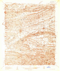
(57)- 1906 Map of Barber
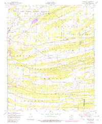
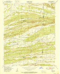
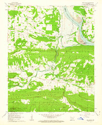
 1906 Barber1906 Print · USGSSebastian County’s ridges and valley settlements are shown here at the start of the twentieth century, during a time of rural expansion. Researchers can trace early family sites and commerce through landmarks like the Toll Bridge and settlements such as Burnville and Sulphur Spring.
 - 1934 Map of Booneville
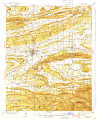
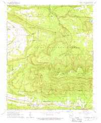
 1934 Booneville1934 Print · USGSLogan County during the mid-1930s reveals a network of small Arkansas settlements and mountain ridges connected by the Rock Island line. Researchers can trace family history through sites like the State Sanitarium, Wesley Chapel, and the Rocky Springs Cem.2 unique versions available
 - 1939 Map of Booneville
 1939 Booneville1939 Print · USGSThe Logan County countryside thrives in the 1930s as a crossroads of the Rock Island railroad and the Petit Jean Creek valley. Genealogists can locate family landmarks like Harvel Cem, the State Sanatorium, and local schools including Shady Grove Sch.3 unique versions available
 - 1943 Map of Fort Smith
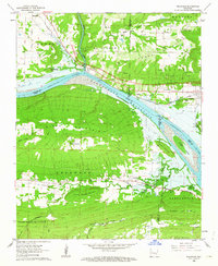
 1943 Fort Smith1943 Print · USGSFort Smith and the Arkansas River valley are shown here during the height of the Second World War as the region became a major military hub. Genealogists and researchers can locate several rural schools and churches, such as St Marys School and Pleasant Ridge Church and Cem, alongside industrial sites like the Strip Mine and Smelter.
 - 1946 Map of Fort Smith
 1946 Fort Smith1946 Print · USGSThe Arkansas-Oklahoma borderlands appear here in the mid-forties, as new reservoirs began to transform the river valleys. Genealogists and historians can trace rail-served towns from Muskogee to Fort Smith and locate landmarks like Camp Chaffee.
 - 1947 Map of Barber, 1954 Print
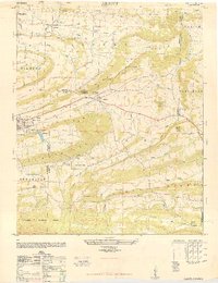
 1947 Barber1954 Print · USGSSebastian County and the surrounding ridges are captured in the late 1940s, showing the intersection of military expansion and rural Arkansas life. Genealogists and historians can trace family locations through Union Ridge Cem, Milltown, and Liberty Ch.
 - 1947 Map of Barber, 1973 Print
 1947 Barber1973 Print · USGSIn the mid-forties, the Arkansas landscape south of the Arkansas River was defined by the expansion of military grounds and the enduring ridge-top settlements. Researchers can find old burial sites like Spencer Cemetery and trace the Chicago Rock Island and Pacific rail line through Barber.2 unique versions available
 - 1947 Map of Ione, 1976 Print
 1947 Ione1976 Print · USGSThe Petit Jean River valley at the Logan and Scott county line is shown here just after the war. Researchers can locate family landmarks like Earl Prairie District School No 66, French Prairie Cemetery, and the old gin mill near Lucas.2 unique versions available
 - 1947 Map of Burnville, 1978 Print
 1947 Burnville1978 Print · USGSSebastian County and Logan County intersect here in the late 1940s as the military and rural farming communities exist side-by-side. Genealogists can trace family footprints at Burnville School, Liberty Church, and Lone Star Cemetery.
 - 1948 Map of Abbott
 1948 Abbott1948 Print · USGSWestern Arkansas at the end of the 1940s reveals a landscape of ridges and rail-side towns along the Rock Island line. Genealogists and local historians can trace family roots through sites like Pine Grove Valley, Crossroads School, and Cantrell Cemetery.4 unique versions available
 - 1951 Map of Ione
 1951 Ione1951 Print · USGSLogan and Scott Counties appear at the start of the 1950s, showing a landscape defined by the winding Petit Jean Creek and the southern Ouachita National Forest. Researchers can locate old community hubs like Ione, Elm Park, and the French Prairie Cemetery.2 unique versions available
 - 1951 Map of Burnville
 1951 Burnville1951 Print · USGSSebastian and Logan counties appear in the early fifties as the military presence at Camp Chaffee met the rural life of Burnville. Genealogists can trace early homesteads and landmarks like Liberty Church, Milltown, and the Burnville School.2 unique versions available
 - 1951 Map of Barber
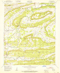
 1951 Barber1951 Print · USGSThe Arkansas Ozark foothills meet military history in the early fifties, where the Camp Chaffee Military Reservation borders rural communities. Genealogists can locate family landmarks like Spencer Cemetery, Mebane Cemetery, and the small settlement of Barber.2 unique versions available
 - 1956 Map of Russellville
 1956 Russellville1956 Print · USGSThe Arkansas River valley and the surrounding Boston Mountains are captured here in the mid-fifties, showing a landscape of small timber towns and new reservoirs. Genealogists can trace family roots through upland settlements like Pelsor and Witts Springs or locate the campus of Arkansas Polytechnic College.2 unique versions available
 - 1961 Map of Coal Hill, 1962 Print
 1961 Coal Hill1962 Print · USGSThe mining and rail corridor of Johnson County comes into focus in the early sixties, showing the industrial landscape before modern reclamation. Genealogists and researchers can trace family plots at Houston Cem or Hardgraves Cem and follow the old MISSOURI PACIFIC line through Coal Hill.2 unique versions available
 - 1961 Map of Hartman, 1962 Print
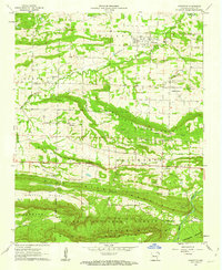
 1961 Hartman1962 Print · USGSThe Arkansas River valley at the start of the sixties reveals a landscape of railroad towns and active coal mining. Genealogists and local historians can trace rural roots at Mount Vernon Ch, Kendall Cem, and the community of Sulphur Springs.3 unique versions available
 - 1961 Map of Scranton, 1962 Print
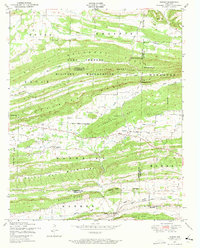
 1961 Scranton1962 Print · USGSLogan County life in the early sixties is centered around Scranton and its surrounding ridge-top communities. Genealogists and historians can trace family locations at Saint Ignatius Ch or numerous burial grounds like Hickory Grove Cem and Ellsworth Cem.3 unique versions available
 - 1961 Map of Paris, 1962 Print
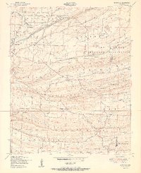
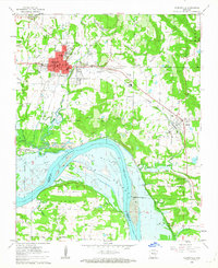
 1961 Paris1962 Print · USGSParis and the surrounding Arkansas River valley are captured in the early 1960s during a period of established mining and agriculture. Researchers can trace local family roots through numerous sites like New Subiaco Academy, Oakwood Cem, and the Missouri Pacific Railroad line.3 unique versions available
 - 1962 Map of New Blaine, 1963 Print
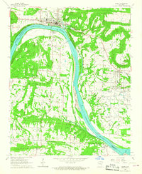
 1962 New Blaine1963 Print · USGSLogan County settlements and the rising waters of the Arkansas River valley are documented here in the early sixties. Genealogists and local historians can trace rural life through St Scholastica Ch, the Old Railroad Grade, and the New Blaine Sch.3 unique versions available
 - 1962 Map of Delaware, 1963 Print
 1962 Delaware1963 Print · USGSThe Arkansas River valley was in a state of flux in the early sixties as the reservoir began to fill. Genealogists and historians can trace family ties at Chastain Cem and Pledger Cem or locate the Old Railroad Grade near Delaware.2 unique versions available
 - 1962 Map of Clarksville, 1963 Print
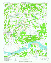
 1962 Clarksville1963 Print · USGSJohnson County is captured in the early sixties as the rising waters of the Dardanelle Reservoir began reshaping the riverfront. Genealogists can locate several family burial grounds including Walton Cem and Gray Cem, alongside the College of the Ozarks campus.3 unique versions available
 - 1964 Map of Russellville
 1964 Russellville1964 Print · USGSMid-century Central Arkansas is defined here by the river-valley towns and the surrounding mountain ranges before the full expansion of the interstate system. Genealogists and historians can trace rail-town development along the Missouri Pacific Railroad and locate landmarks like Arkansas Polytechnic College or Petit Jean State Park.
 - 1965 Map of Fort Smith
 1965 Fort Smith1965 Print · USGSEastern Oklahoma and Western Arkansas are captured here during a period of massive post-war change as new reservoirs reshaped the river valleys. Genealogists and historians can trace the rail networks of the Midland Valley RR and find established communities like Stilwell, Sallisaw, and Stigler.
 - 1966 Map of Ozark, 1967 Print
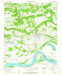
 1966 Ozark1967 Print · USGSThe Arkansas River valley undergoes major changes in the 1960s as industrial progress meets traditional settlements. Genealogists and local historians can trace family roots through Highland Cemetery and St Marys Ch, or locate sites like Webb City Sch before the reservoir waters rose.2 unique versions available
 - 1966 Map of Blue Mountain, 1967 Print
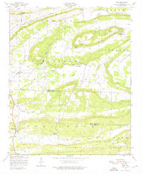
 1966 Blue Mountain1967 Print · USGSThe Arkansas high country of the mid-1960s is centered here on the summits of Magazine Mountain and Signal Hill. Genealogists and local historians can locate remote landmarks like Liberty Ch, Little Hope Cem, and the tracks of the Chicago Rock Island and Pacific.2 unique versions available
Showing maps 1-25 of 57
Top cities of Logan County
- Booneville historical maps
- Paris historical maps
- Magazine historical maps
- Subiaco historical maps
- Caulksville historical maps
- Scranton historical maps
See more
Frequently asked questions
- What are the different types of historical maps available for Logan County?
- What is the oldest map of Logan County?
- Where can I purchase historical maps of Logan County for my home or office?
- Where can I download high-res historical maps of Logan County?
- Are there historical topographic maps available for Logan County?
- Is there historical aerial imagery available for Logan County?
- Where are historical maps of Logan County sourced from?