1980s Maps of Logan County, Arkansas
Explore 10 historic maps of Logan County from the 1980s. These maps offer a rare glimpse into what life looked like during the 1980s — showing old roads, neighborhoods, homes, and landmarks that have changed or disappeared over time.
Whether you're researching your family's past, planning a metal detecting trip, or studying how Logan County's landscape evolved across the 1980s, these high-resolution maps are a powerful tool for exploring the history of this region.
- Focus on a specific era: All maps on this page are from the 1980s, giving you a focused view of this time period.
- See what’s changed: Compare century-old streets, trails, and buildings to today's modern landscape using overlays and satellite layers.
- Research with precision: Use these maps for genealogy, historical research, land use analysis, or educational projects.
- View, download, or print: Maps are fully viewable online in high resolution, and can be downloaded or printed for your own records.
Start exploring Logan County's history through authentic maps from the 1980s. This is your window into the past.
Logan County, AR maps
(10)- 1983 Map of Golden City
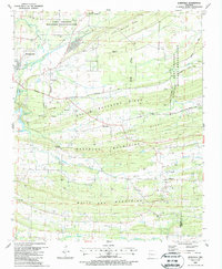
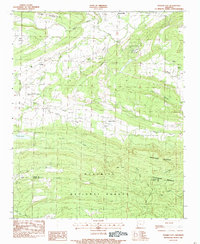 1983 Golden City1983 Print · USGSNear the northern edge of the Ouachita mountains in the early eighties, this survey captures a landscape of river-valley farms and state institutions. Researchers can trace family sites at Carolan Ch or identify ancestors at Golden City Cem and Mixon Cem.
 - 1983 Map of Magazine
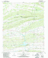
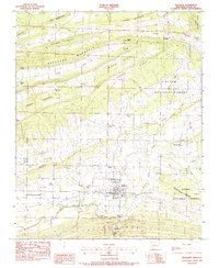 1983 Magazine1983 Print · USGSLogan County during the early 1980s reveals a landscape of high ridges and river valleys centered on the town of Magazine. Genealogists and local historians can trace rural roots through numerous sites like Cauthron Memorial Cem, Bluff View Com, and the Petit Jean River crossings.
 - 1983 Map of Sugar Grove
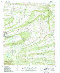
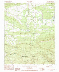 1983 Sugar Grove1983 Print · USGSSugar Grove and the surrounding Ouachita foothills are captured here in the late seventies just before the turn of the decade. Researchers can locate remote family landmarks like the Ethan Davis Cem, Lick Creek Ch, and the crossing at Third Bridge.
 - 1983 Map of Booneville
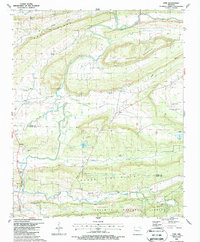
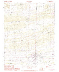 1983 Booneville1983 Print · USGSIn the early 1980s, the Arkansas Ozark foothills around Booneville were defined by high ridges and small valley settlements. Trace local history through landmark sites like Chismville, the Oak Hill Cem, and the rural Walnut Grove Ch.
 - 1984 Map of Russellville
 1984 Russellville1984 Print · USGSThe Arkansas River valley in the mid-eighties shows a landscape defined by the rise of Lake Dardanelle and the enduring presence of the Ozark National Forest. Researchers can find historical institutions like Arkansas Tech Univ and Sacred Heart Church or trace the routes of the Missouri Pacific RR.2 unique versions available
 - 1984 Map of Russellville
 1984 Russellville1984 Print · USGSThe Arkansas River valley was undergoing significant change in the 1950s as transportation and water management reshaped the region from Russellville to Conway. Researchers can trace the era's rail networks like the Missouri Pacific RR and explore landmarks like Magazine Mountain and Petit Jean State Park.
 - 1987 Map of Burnville, 1988 Print
 1987 Burnville1988 Print · USGSSebastian and Logan counties appear during the late eighties as a landscape of ridgelines and rural settlements. Researchers can locate family landmarks like Dawson Mem Cem and Clarks Chapel or trace the early energy footprint of numerous Gas Wells.
 - 1987 Map of Barber, 1988 Print
 1987 Barber1988 Print · USGSIn the late 1980s, this portion of the Arkansas Ozark foothills shows the expansion of the natural gas industry alongside traditional rural settlements. Genealogists can locate several local burial sites including Washburn Cem and Mannis Cem, or trace the Old RR Grade near Barber.
 - 1987 Map of Abbott, 1988 Print
 1987 Abbott1988 Print · USGSThe borderlands of Sebastian, Scott, and Logan counties are captured in the late eighties, showing a landscape defined by natural gas extraction and wooded wilderness. Researchers can trace an Old Railroad Grade and locate numerous family burial sites, including Union Ridge Cem and Sorrels Cem.
 - 1987 Map of Ione, 1988 Print
 1987 Ione1988 Print · USGSLogan and Scott counties in the late 1980s are defined by the winding Petit Jean River and the rural communities of the Ouachita foothills. Researchers can trace family sites at Doss Cem and Tomlinson Cem or locate the Prison Farm.
End of results
Showing maps 1-10 of 10
Top cities of Logan County
- Booneville historical maps
- Paris historical maps
- Magazine historical maps
- Subiaco historical maps
- Caulksville historical maps
- Scranton historical maps
See more
Frequently asked questions
- What are the different types of historical maps available for Logan County?
- What is the oldest map of Logan County?
- Where can I purchase historical maps of Logan County for my home or office?
- Where can I download high-res historical maps of Logan County?
- Are there historical topographic maps available for Logan County?
- Is there historical aerial imagery available for Logan County?
- Where are historical maps of Logan County sourced from?