1940s Maps of Mississippi County, Arkansas
Explore 5 historic maps of Mississippi County from the 1940s. These maps offer a rare glimpse into what life looked like during the 1940s — showing old roads, neighborhoods, homes, and landmarks that have changed or disappeared over time.
Whether you're researching your family's past, planning a metal detecting trip, or studying how Mississippi County's landscape evolved across the 1940s, these high-resolution maps are a powerful tool for exploring the history of this region.
- Focus on a specific era: All maps on this page are from the 1940s, giving you a focused view of this time period.
- See what’s changed: Compare century-old streets, trails, and buildings to today's modern landscape using overlays and satellite layers.
- Research with precision: Use these maps for genealogy, historical research, land use analysis, or educational projects.
- View, download, or print: Maps are fully viewable online in high resolution, and can be downloaded or printed for your own records.
Start exploring Mississippi County's history through authentic maps from the 1940s. This is your window into the past.
Mississippi County, AR maps
(5)- 1940 Map of Deckerville, 1942 Print
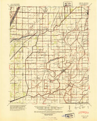
 1940 Deckerville1942 Print · USGSCrittenden and Poinsett counties are shown here as the local river-and-rail economy matured before the war. Genealogists can trace family landmarks like the King Solomon Sch & Cem, Booker Sch, and New Bethlehem Ch & Cem.
 - 1940 Map of Hayti, 1943 Print
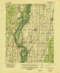
 1940 Hayti1943 Print · USGSSoutheast Missouri’s fertile lowlands are captured here in the early 1940s, showing a landscape defined by drainage canals and rail-side commerce. Genealogists can trace family roots through numerous small schools and cemeteries, such as Cupp Cem and Gibson Sch.2 unique versions available
 - 1941 Map of Leachville, 1943 Print
 1941 Leachville1943 Print · USGSNortheast Arkansas and the Missouri bootheel border region appear here in the early 1940s as a landscape of river-bottom settlements and new drainage canals. Genealogists can trace family roots through numerous local schools like Turkey Run Sch and churches such as Walnut Grove Ch & Cem.
 - 1941 Map of Manila, 1945 Print
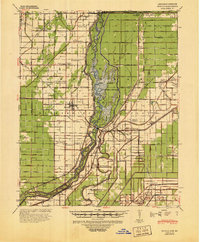 1941 Manila1945 Print · USGSIn the early 1940s, the Arkansas-Missouri line was a landscape defined by reclaimed wetlands and the Big Lake Reservation. Genealogists and local historians can trace rural family life through landmarks like Boxelder Ch & Cem, McFerrin Plantation, and Skidway Sch.
 - 1941 Map of Marked Tree, 1946 Print
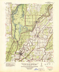 1941 Marked Tree1946 Print · USGSPoinsett County at the start of the 1940s reveals a landscape of massive drainage projects and river engineering. Trace the early footprints of Marked Tree and Lepanto alongside rural landmarks like Frys Mill, Pilgrims Rest Ch, and the Spear Lake Sch & Cem.2 unique versions available
End of results
Showing maps 1-5 of 5
Top cities of Mississippi County
- Blytheville historical maps
- Osceola historical maps
- Gosnell historical maps
- Manila historical maps
- Leachville historical maps
- Luxora historical maps
See more
Frequently asked questions
- What are the different types of historical maps available for Mississippi County?
- What is the oldest map of Mississippi County?
- Where can I purchase historical maps of Mississippi County for my home or office?
- Where can I download high-res historical maps of Mississippi County?
- Are there historical topographic maps available for Mississippi County?
- Is there historical aerial imagery available for Mississippi County?
- Where are historical maps of Mississippi County sourced from?