1960s Maps of Mississippi County, Arkansas
Explore 6 historic maps of Mississippi County from the 1960s. These maps offer a rare glimpse into what life looked like during the 1960s — showing old roads, neighborhoods, homes, and landmarks that have changed or disappeared over time.
Whether you're researching your family's past, planning a metal detecting trip, or studying how Mississippi County's landscape evolved across the 1960s, these high-resolution maps are a powerful tool for exploring the history of this region.
- Focus on a specific era: All maps on this page are from the 1960s, giving you a focused view of this time period.
- See what’s changed: Compare century-old streets, trails, and buildings to today's modern landscape using overlays and satellite layers.
- Research with precision: Use these maps for genealogy, historical research, land use analysis, or educational projects.
- View, download, or print: Maps are fully viewable online in high resolution, and can be downloaded or printed for your own records.
Start exploring Mississippi County's history through authentic maps from the 1960s. This is your window into the past.
Mississippi County, AR maps
(6)- 1961 Map of Jericho, 1963 Print
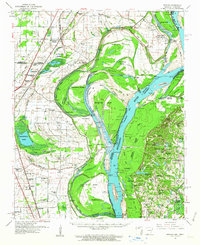 1961 Jericho1963 Print · USGSThe Mississippi River delta at the start of the 1960s reveals a world of island farming and rail-side settlements along the Arkansas-Tennessee border. Genealogists can trace family roots through numerous local landmarks, including Jericho, Clarkedale, and the St Paul School and Church.
 - 1961 Map of Hales Point, 1963 Print
 1961 Hales Point1963 Print · USGSThe Tennessee-Arkansas river borderland is captured here in the early sixties, showing the complex hydrology of the Mississippi River. Researchers can trace old community foundations and rural heritage through landmarks like Henning Grove Ch & Sch, Ashport Cem, and Hales Point.2 unique versions available
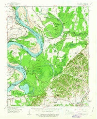
 - 1962 Map of Jericho
 1962 Jericho1962 Print · USGSThe riverfront border of Arkansas and Tennessee is captured here in the early sixties, showing a landscape shaped by the Mississippi River. Genealogists and local historians can trace family roots through sites like Jericho, James Mill, and Lambethville, or locate rural landmarks such as Pecan Point Cem and the Shawnee Sch.
 - 1962 Map of Hales Point
 1962 Hales Point1962 Print · USGSThe Tennessee-Arkansas borderlands come alive in the early sixties as the Mississippi River carves through Lauderdale County. Researchers can trace family roots at St Luke Cem, locate the Matthews Ch & Sch, or explore the riverfront at Hales Point.
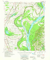
 - 1963 Map of Osceola, 1966 Print
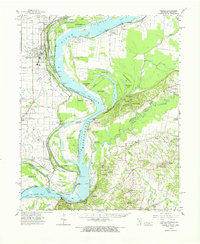 1963 Osceola1966 Print · USGSThe river borders of Tennessee and Arkansas meet along the bends of the Mississippi in the early sixties. Genealogists and historians can trace riverside settlements like Golddust and Randolph, or locate rural landmarks like Raven Cross Cem and St Johns Ch.
 - 1965 Map of Osceola
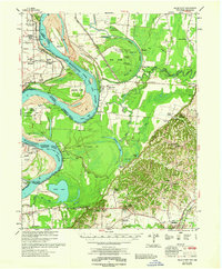
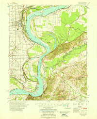 1965 Osceola1965 Print · USGSOsceola and the Mississippi River bottomlands are captured here in the mid-sixties, showing the complex boundary between Arkansas and Tennessee. Researchers can trace family roots through numerous rural landmarks like Golddust Ch & Sch, Grider, and Smyrna Ch.
End of results
Showing maps 1-6 of 6
Top cities of Mississippi County
- Blytheville historical maps
- Osceola historical maps
- Gosnell historical maps
- Manila historical maps
- Leachville historical maps
- Luxora historical maps
See more
Frequently asked questions
- What are the different types of historical maps available for Mississippi County?
- What is the oldest map of Mississippi County?
- Where can I purchase historical maps of Mississippi County for my home or office?
- Where can I download high-res historical maps of Mississippi County?
- Are there historical topographic maps available for Mississippi County?
- Is there historical aerial imagery available for Mississippi County?
- Where are historical maps of Mississippi County sourced from?