1930s Maps of Mississippi County, Arkansas
Explore 6 historic maps of Mississippi County from the 1930s. These maps offer a rare glimpse into what life looked like during the 1930s — showing old roads, neighborhoods, homes, and landmarks that have changed or disappeared over time.
Whether you're researching your family's past, planning a metal detecting trip, or studying how Mississippi County's landscape evolved across the 1930s, these high-resolution maps are a powerful tool for exploring the history of this region.
- Focus on a specific era: All maps on this page are from the 1930s, giving you a focused view of this time period.
- See what’s changed: Compare century-old streets, trails, and buildings to today's modern landscape using overlays and satellite layers.
- Research with precision: Use these maps for genealogy, historical research, land use analysis, or educational projects.
- View, download, or print: Maps are fully viewable online in high resolution, and can be downloaded or printed for your own records.
Start exploring Mississippi County's history through authentic maps from the 1930s. This is your window into the past.
Mississippi County, AR maps
(6)- 1931 Map of Jericho
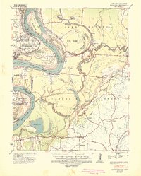
 1931 Jericho1931 Print · USGSThe Arkansas-Tennessee borderlands appear here in the early 1930s, defined by the winding Mississippi and its evolving islands. Genealogists and researchers can trace old river landings like Pecan Point, rail stops at Jericho, and the rural Mt Vernon Church.
 - 1939 Map of Jericho, 1941 Print
 1939 Jericho1941 Print · USGSThe shifting Mississippi River bottomlands come to life in this late 1930s survey of the Arkansas-Tennessee border. Researchers can trace historical river landings like Happy Valley Ldg, see the vanished tracks of the St Louis San Francisco RR, and locate rural landmarks such as Mt Olive Ch & Sch.
 - 1939 Map of Hales Point, 1943 Print
 1939 Hales Point1943 Print · USGSThe riverine borders of the Mississippi and Obion Rivers come alive in the late 1930s, showing a landscape of landings, islands, and flood control projects. Genealogists can trace family footprints through sites like Buckner Cem, Hickman, and Henning Grove Ch & Sch.
 - 1939 Map of Caruthersville, 1943 Print
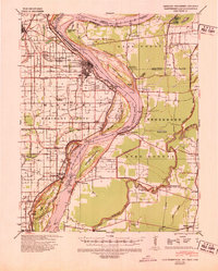 1939 Caruthersville1943 Print · USGSThe Missouri bootheel and Tennessee riverfront are documented here just before the Second World War, showing a landscape defined by the Mississippi's bends. Researchers can trace rural lineages through local landmarks like Mt Olive Ch & Sch, Mengelwood, and the many riverfront schools.2 unique versions available
 - 1939 Map of Blytheville, 1944 Print
 1939 Blytheville1944 Print · USGSMississippi County at the end of the Depression reveals a landscape of engineered drainage and thriving rail junctions. Genealogists and local historians can trace family locations near Blytheville, Cards Chapel & Cem, and the river landing at Ashport.
 - 1939 Map of Evadale, 1954 Print
 1939 Evadale1954 Print · USGSMississippi County, Arkansas, at the end of the 1930s was a landscape being reshaped by the drainage of the Sunk Lands. Local historians can trace the foundations of several communities and rural landmarks, including Little Bethlehem Ch & Cem, the company town of Wilson, and the early settlement of Dyess.
End of results
Showing maps 1-6 of 6
Top cities of Mississippi County
- Blytheville historical maps
- Osceola historical maps
- Gosnell historical maps
- Manila historical maps
- Leachville historical maps
- Luxora historical maps
See more
Frequently asked questions
- What are the different types of historical maps available for Mississippi County?
- What is the oldest map of Mississippi County?
- Where can I purchase historical maps of Mississippi County for my home or office?
- Where can I download high-res historical maps of Mississippi County?
- Are there historical topographic maps available for Mississippi County?
- Is there historical aerial imagery available for Mississippi County?
- Where are historical maps of Mississippi County sourced from?