1930s Maps of Newton County, Arkansas
Explore 6 historic maps of Newton County from the 1930s. These maps offer a rare glimpse into what life looked like during the 1930s — showing old roads, neighborhoods, homes, and landmarks that have changed or disappeared over time.
Whether you're researching your family's past, planning a metal detecting trip, or studying how Newton County's landscape evolved across the 1930s, these high-resolution maps are a powerful tool for exploring the history of this region.
- Focus on a specific era: All maps on this page are from the 1930s, giving you a focused view of this time period.
- See what’s changed: Compare century-old streets, trails, and buildings to today's modern landscape using overlays and satellite layers.
- Research with precision: Use these maps for genealogy, historical research, land use analysis, or educational projects.
- View, download, or print: Maps are fully viewable online in high resolution, and can be downloaded or printed for your own records.
Start exploring Newton County's history through authentic maps from the 1930s. This is your window into the past.
Newton County, AR maps
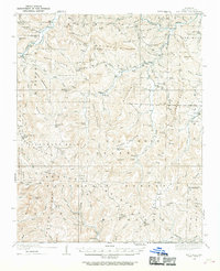
(6)- 1932 Map of Treat, 1972 Print
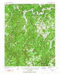
 1932 Treat1972 Print · USGSThe Arkansas Ozarks come alive in this early 1930s survey of the Piney Creek highlands. Researchers can trace rural life through numerous one-room schools like Ross Sch and remote outposts like Sand Gap Felsor PO or Fort Douglas.
 - 1933 Map of Mt Judea, 1970 Print
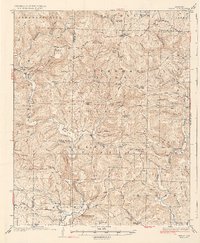
 1933 Mt Judea1970 Print · USGSNewton County's mountain communities were still deeply isolated during the early 1930s, connected by winding roads through the Boston Mountains. Genealogists can locate family homesteads near numerous local institutions like Union Hill Sch or the remote Macedonia Sch.
 - 1934 Map of Treat
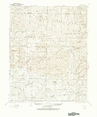
 1934 Treat1934 Print · USGSPope County highlands during the early thirties show a rugged network of forest outposts and mountain schools. Researchers can trace the layout of community sites like Sand Gap Pelsor PO, Ross Sch, and the Fairview Fire Tower.3 unique versions available
 - 1934 Map of Ozone, 1975 Print
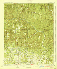
 1934 Ozone1975 Print · USGSThe Boston Mountains of Arkansas appear in the mid-1930s as a landscape of isolated mountain settlements and family farms. Researchers can trace genealogical roots at the Gillian Settlement, locate long-gone schools like Mountain Hall Sch, or find rural landmarks including the Devils Knob Fire Tower.
 - 1936 Map of Ozone
 1936 Ozone1936 Print · USGSThe Boston Mountains of Johnson and Newton counties appear in the mid-thirties as a landscape of isolated ridges and winding hollows. Genealogists can trace family roots through the many rural schools and churches, including Murray Chapel Sch, Gillian Settlement, and the Hignite Cem.3 unique versions available
 - 1939 Map of Snowball, 1967 Print
 1939 Snowball1967 Print · USGSSearcy and Newton Counties are shown here just before the 1940s, highlighting a landscape of dispersed mountain farmsteads and rural schoolhouses. Genealogists can trace family names through landmarks like Arnold Cem, Witts Springs, and Juanita Sch.2 unique versions available
End of results
Showing maps 1-6 of 6
Top cities of Newton County
Frequently asked questions
- What are the different types of historical maps available for Newton County?
- What is the oldest map of Newton County?
- Where can I purchase historical maps of Newton County for my home or office?
- Where can I download high-res historical maps of Newton County?
- Are there historical topographic maps available for Newton County?
- Is there historical aerial imagery available for Newton County?
- Where are historical maps of Newton County sourced from?