1960s Maps of Sevier County, Arkansas
Explore 11 historic maps of Sevier County from the 1960s. These maps offer a rare glimpse into what life looked like during the 1960s — showing old roads, neighborhoods, homes, and landmarks that have changed or disappeared over time.
Whether you're researching your family's past, planning a metal detecting trip, or studying how Sevier County's landscape evolved across the 1960s, these high-resolution maps are a powerful tool for exploring the history of this region.
- Focus on a specific era: All maps on this page are from the 1960s, giving you a focused view of this time period.
- See what’s changed: Compare century-old streets, trails, and buildings to today's modern landscape using overlays and satellite layers.
- Research with precision: Use these maps for genealogy, historical research, land use analysis, or educational projects.
- View, download, or print: Maps are fully viewable online in high resolution, and can be downloaded or printed for your own records.
Start exploring Sevier County's history through authentic maps from the 1960s. This is your window into the past.
Sevier County, AR maps
(11)- 1960 Map of El Dorado
 1960 El Dorado1960 Print · USGSSouth Central Arkansas in the late fifties was a hub of energy production and defense industry. Researchers can trace the extensive Oil and Gas Fields around El Dorado or locate family landmarks like Old Park Cem and New Hope Church.
 - 1962 Map of McAlester
 1962 McAlester1962 Print · USGSSoutheastern Oklahoma and western Arkansas are shown here during the early sixties, a time of transition for the region's mountain communities and timberlands. Researchers can trace the paths of the Kansas City Southern RR through Heavener or locate settlements like Talihina and Broken Bow near the Kiamichi Mountains.2 unique versions available
 - 1964 Map of Gillham Dam, 1966 Print
 1964 Gillham Dam1966 Print · USGSThe Cossatot River valley in the mid-1960s was a landscape in transition as the massive Gillham Dam project began. Researchers can trace the original river crossings at Three Shoes Ford or locate family plots at New Hope Cem and Cossatot Cem.
 - 1964 Map of Gillham, 1966 Print
 1964 Gillham1966 Print · USGSSevier and Polk counties are shown here in the mid-1960s, just as the regional landscape began to adapt to new water infrastructure. Researchers can trace the Kansas City Southern line through Grannis and Gillham, or locate family sites like Overturf Cem and Almond Ch.2 unique versions available
 - 1965 Map of McAlester
 1965 McAlester1965 Print · USGSSoutheastern Oklahoma and western Arkansas appear here in the mid-1960s, showing the intersection of the timber industry and the growing reservoir system. Genealogists can trace family roots through settlements like Antlers, Idabel, and Kiowa or follow the historic routes of the Kansas City Southern Ry.3 unique versions available
 - 1965 Map of Chapel Hill, 1967 Print
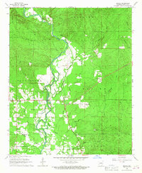
 1965 Chapel Hill1967 Print · USGSThe border country of Sevier County comes alive in the mid-sixties as the De Queen Reservoir begins to reshape the landscape. Local historians can trace family roots through Ultima Thule, the Chapel Hill Cem, and the path of the De Queen and Eastern railroad.2 unique versions available
 - 1966 Map of De Queen, 1967 Print
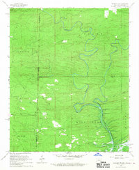
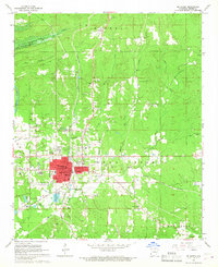 1966 De Queen1967 Print · USGSDe Queen and Sevier County are captured in the mid-1960s just as a new reservoir began to reshape the local geography. Trace the path of the Kansas City Southern railroad through Process City or locate family sites like Redman Cemetery and Smyrna Ch.
 - 1966 Map of Dierks Dam, 1967 Print
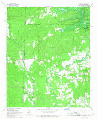
 1966 Dierks Dam1967 Print · USGSThe Saline River valley is captured during the mid-sixties as it prepared for the construction of Dierks Dam. Researchers can trace soon-to-be-submerged landmarks like Mail Ford or locate rural family sites near Euclid and Burg.
 - 1966 Map of Dierks, 1967 Print
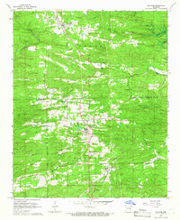
 1966 Dierks1967 Print · USGSThe rail and river geography of Howard and Sevier Counties comes into focus during the mid-sixties. Genealogists and local historians can trace family sites near Dierks, Provo, and Bethany, or locate rural landmarks like Oak Hill Ch and Potts Cem.
 - 1966 Map of De Queen NW, 1967 Print
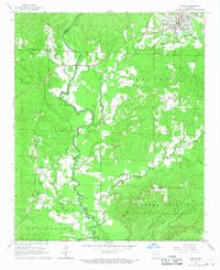
 1966 De Queen NW1967 Print · USGSThe Arkansas-Oklahoma borderlands appear here in the mid-1960s just as the De Queen Reservoir was reshaping the local landscape. Researchers can trace rural lineages through the locations of Oak Grove Cem, Mill Creek Cem, and the Midway Ch near the banks of Bellah Creek.2 unique versions available
 - 1966 Map of Geneva, 1967 Print
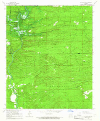
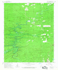
 1966 Geneva1967 Print · USGSSevier County's rural landscape is captured here in the mid-1960s, centered on the winding Cossatot River and its many tributaries. Genealogists and local historians can trace family locations near the Woffords Chapel Cem, the settlement of Geneva, or the Bethel Lookout Tower.
End of results
Showing maps 1-11 of 11
Top cities of Sevier County
- De Queen historical maps
- Horatio historical maps
- Lockesburg historical maps
- Gillham historical maps
- Ben Lomond historical maps
Frequently asked questions
- What are the different types of historical maps available for Sevier County?
- What is the oldest map of Sevier County?
- Where can I purchase historical maps of Sevier County for my home or office?
- Where can I download high-res historical maps of Sevier County?
- Are there historical topographic maps available for Sevier County?
- Is there historical aerial imagery available for Sevier County?
- Where are historical maps of Sevier County sourced from?