1960s Maps of Stone County, Arkansas
Explore 12 historic maps of Stone County from the 1960s. These maps offer a rare glimpse into what life looked like during the 1960s — showing old roads, neighborhoods, homes, and landmarks that have changed or disappeared over time.
Whether you're researching your family's past, planning a metal detecting trip, or studying how Stone County's landscape evolved across the 1960s, these high-resolution maps are a powerful tool for exploring the history of this region.
- Focus on a specific era: All maps on this page are from the 1960s, giving you a focused view of this time period.
- See what’s changed: Compare century-old streets, trails, and buildings to today's modern landscape using overlays and satellite layers.
- Research with precision: Use these maps for genealogy, historical research, land use analysis, or educational projects.
- View, download, or print: Maps are fully viewable online in high resolution, and can be downloaded or printed for your own records.
Start exploring Stone County's history through authentic maps from the 1960s. This is your window into the past.
Stone County, AR maps
(12)- 1964 Map of Russellville
 1964 Russellville1964 Print · USGSMid-century Central Arkansas is defined here by the river-valley towns and the surrounding mountain ranges before the full expansion of the interstate system. Genealogists and historians can trace rail-town development along the Missouri Pacific Railroad and locate landmarks like Arkansas Polytechnic College or Petit Jean State Park.
 - 1964 Map of Harrison
 1964 Harrison1964 Print · USGSThe Ozark and Boston Mountains of Arkansas and Missouri are captured here in the mid-sixties, showing the rugged highlands before extensive modern development. Genealogists and historians can trace family-named peaks like Gaither Mountain and follow the St Louis-San Francisco RR through Monett and Purdy.
 - 1964 Map of Calico Rock, 1965 Print
 1964 Calico Rock1965 Print · USGSThe White River region at the height of the mid-sixties reveals a landscape of isolated river settlements and high Ozark ridges. Researchers can trace the river's impact through the Ghesmond Ferry and find family sites like the Old Optimus Cem or Bethel Springs Sch.4 unique versions available
 - 1964 Map of Norfork Dam South, 1965 Print
 1964 Norfork Dam South1965 Print · USGSThe Ozark highlands of Baxter and Izard counties come alive in the mid-1960s as the White River winds through deep forest. Genealogists and historians can trace the Missouri Pacific rail line past Old Joe to the riverside town of Calico Rock.4 unique versions available
 - 1964 Map of Boswell, 1965 Print
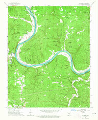
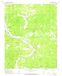 1964 Boswell1965 Print · USGSThe White River loops through the Ozarks in the mid-1960s, marking the boundary between Stone and Izard counties. Genealogists can trace family names at Mount Olive Cem and Optimus Cem or locate the old Missouri Pacific line at Boswell.4 unique versions available
 - 1964 Map of Guion, 1965 Print
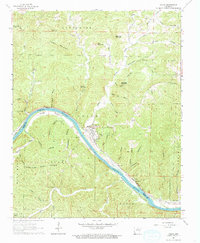 1964 Guion1965 Print · USGSThe White River valley and the industrial riverside town of Guion are captured here in the mid-1960s. Researchers can trace the Missouri Pacific rail line past numerous quarries, finding family history at Jones Bottom Cem or Arnold.
 - 1964 Map of Sylamore, 1965 Print
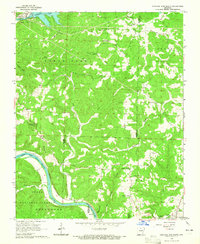
 1964 Sylamore1965 Print · USGSThe White River corridor of mid-century Stone County reveals a landscape of isolated mountain settlements and riverside rail industry. Trace family history through the Jeffery Cem and Sylamore Cem, or locate the old Ferry crossing near the Missouri Pacific line.3 unique versions available
 - 1966 Map of Norfork SE, 1967 Print
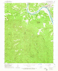
 1966 Norfork SE1967 Print · USGSIn the mid-1960s, this area of the Arkansas Ozarks remained a patchwork of national forest and family landmarks near the Baxter and Stone County line. Genealogists and hikers can trace old routes like Advance Road to find the Acklin Cem and the Lookout Tower on Push Mountain.3 unique versions available
 - 1969 Map of Marcella, 1971 Print
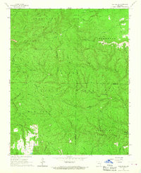
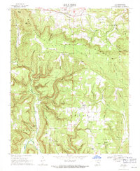
 1969 Marcella1971 Print · USGSStone County's rugged Ozark terrain is documented here in the late sixties, showing a landscape of isolated ridges and tight-knit communities. Genealogists and historians can locate family landmarks such as Dugan Cem, Kelly and Ford Cem, and the Arbanna Ch church.2 unique versions available
 - 1969 Map of Mountain View SW, 1971 Print
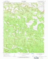 1969 Mountain View SW1971 Print · USGSStone County’s rural Ozark landscape is documented here in the late sixties, showing a terrain defined by ridges and deep hollows. Researchers can locate family landmarks and early congregations like the Mennonite Ch, Fredonia Cem, and the settlement of Sunny Land.
 - 1969 Map of Fox, 1971 Print
 1969 Fox1971 Print · USGSThe Ozark plateau around the communities of Timbo and Fox appears in the late sixties as a network of ridge-top settlements and deep timbered hollows. Researchers can locate remote landmarks like Our Lady of Victory Ch, the Rural Special Sch, and Ramsey Cem.2 unique versions available
 - 1969 Map of Mountain View, 1971 Print
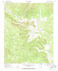
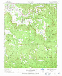 1969 Mountain View1971 Print · USGSStone County life in the late sixties is centered around the growth of Mountain View and the surrounding timbered hollows. Genealogists can trace family roots through numerous sites like Flatwoods Cem, Nirkee Chapel, and the community at Luber.
End of results
Showing maps 1-12 of 12
Top cities of Stone County
Frequently asked questions
- What are the different types of historical maps available for Stone County?
- What is the oldest map of Stone County?
- Where can I purchase historical maps of Stone County for my home or office?
- Where can I download high-res historical maps of Stone County?
- Are there historical topographic maps available for Stone County?
- Is there historical aerial imagery available for Stone County?
- Where are historical maps of Stone County sourced from?