1970s Maps of Stone County, Arkansas
Explore 15 historic maps of Stone County from the 1970s. These maps offer a rare glimpse into what life looked like during the 1970s — showing old roads, neighborhoods, homes, and landmarks that have changed or disappeared over time.
Whether you're researching your family's past, planning a metal detecting trip, or studying how Stone County's landscape evolved across the 1970s, these high-resolution maps are a powerful tool for exploring the history of this region.
- Focus on a specific era: All maps on this page are from the 1970s, giving you a focused view of this time period.
- See what’s changed: Compare century-old streets, trails, and buildings to today's modern landscape using overlays and satellite layers.
- Research with precision: Use these maps for genealogy, historical research, land use analysis, or educational projects.
- View, download, or print: Maps are fully viewable online in high resolution, and can be downloaded or printed for your own records.
Start exploring Stone County's history through authentic maps from the 1970s. This is your window into the past.
Stone County, AR maps
(15)- 1972 Map of Onia, 1973 Print
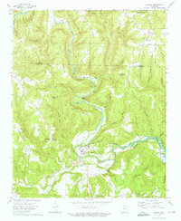
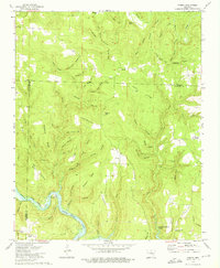
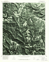
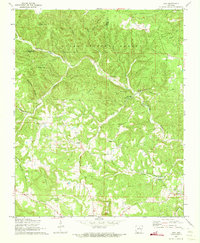 1972 Onia1973 Print · USGSStone County in the early seventies remains a landscape of isolated valleys and tight-knit rural settlements. Genealogists can locate family-named sites such as Stevens Cem and Farris Cem, alongside local congregations like Friendship Ch and Bethany Ch.2 unique versions available
 - 1972 Map of Landis, 1973 Print
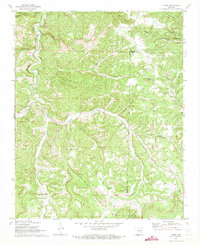 1972 Landis1973 Print · USGSThe Ozark highlands of northern Arkansas are captured here in the early seventies, showcasing a network of remote hollows and mountain ridges. Genealogists can locate several family burial sites and country churches including Landis Cem, Scribner Cem, and Bluff Springs Ch.2 unique versions available
 - 1972 Map of Fiftysix, 1973 Print
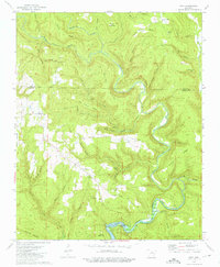
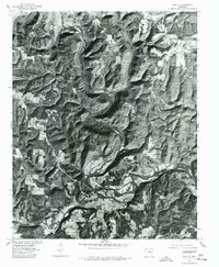
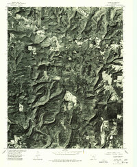
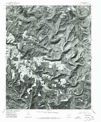
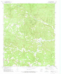 1972 Fiftysix1973 Print · USGSStone County, Arkansas, comes to life in the early seventies, showing the remote ridge-top settlements and cavern systems of the Ozarks. Genealogists and hikers can trace the paths to Fiftysix, Blanchard Caverns, and the Red Doors Cemetery.3 unique versions available
 - 1973 Map of Oxley, 1975 Print
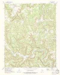 1973 Oxley1975 Print · USGSThe Ozark plateau meets the winding Middle Fork Little Red River in the early 1970s, where three counties converge among steep ridges. Genealogists and hikers can locate family landmarks like Mabrey Cem, the community of Elba, and the heights of Styles Mountain.2 unique versions available
 - 1973 Map of Shirley, 1975 Print
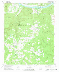
 1973 Shirley1975 Print · USGSThe river town of Shirley and the budding community of Fairfield Bay are shown in the early seventies as this highland region transformed. Trace local family history at Settlement Cemetery or follow the path of the Old Railroad Grade along the river.3 unique versions available
 - 1973 Map of Old Lexington, 1975 Print
 1973 Old Lexington1975 Print · USGSVan Buren and Stone counties are shown here in the early seventies, a landscape of high ridges and deep hollows. Researchers can locate the early settlements of Old Lexington and Old Botkinburg, alongside family landmarks like Holly Mountain Cem and Natural Bridge.2 unique versions available
 - 1973 Map of Concord, 1975 Print
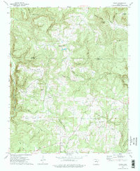
 1973 Concord1975 Print · USGSNorth central Arkansas highlands meet the river valley in the 1970s, as small mountain communities like Concord and Almond grew near the Indian Treaty Boundary. Genealogists can locate family landmarks such as Bellmore Cem and Banner Ch tucked between the ridges and river sloughs.
 - 1973 Map of Prim, 1975 Print
 1973 Prim1975 Print · USGSThe Ozark foothills in Cleburne and Stone Counties are shown here in the early 1970s as the Little Red River winds through the deep hollows. Family history researchers can locate several rural landmarks including the Everett Cem, Signal Hill Ch, and the remote Ramer Ford.
 - 1973 Map of Drasco, 1975 Print
 1973 Drasco1975 Print · USGSThe borderlands of Cleburne and Stone counties appear here in the early 1970s, showing a landscape of family-named ridges and isolated hollows. You can trace early cemetery locations like Macedonia Cem or find the historic Treaty Boundary near Schoolhouse Hill.2 unique versions available
 - 1973 Map of Parma, 1975 Print
 1973 Parma1975 Print · USGSThe northern reaches of the Ozarks meet the rising waters of Greers Ferry Lake in the early seventies. Genealogists and local historians can trace the settlements of Parma and Brewer, or locate the Smart Cem and Sunny Slope Ch.2 unique versions available
 - 1976 Map of Shirley, 1977 Print
 1976 Shirley1977 Print · USGSIn the mid-1970s, the wooded hills of Van Buren County remained defined by the winding course of the Middle Fork Little Red River. Genealogists and local historians can trace the clearings and homesites around Shirley and Rushing as they appeared on the ground decades ago.
 - 1976 Map of Parma, 1977 Print
 1976 Parma1977 Print · USGSNorth-central Arkansas in the mid-seventies is captured in this detailed aerial perspective of the timbered ridges near Parma. Researchers can trace the winding course of the Middle Fork Little Red River and the expanding shoreline of Greers Ferry Lake.
 - 1976 Map of Prim, 1977 Print
 1976 Prim1977 Print · USGSCleburne County settlements and hill country are captured in this mid-seventies orthophotoquad. Researchers can trace rural property clearings and homesites near Prim and Woodrow, or follow the winding shoreline of Greers Ferry Lake.
 - 1976 Map of Old Lexington, 1977 Print
 1976 Old Lexington1977 Print · USGSVan Buren County in the mid-1970s is captured in this detailed aerial perspective of the Ozark foothills. Researchers can trace the rural layout of Old Lexington and Old Botkinburg while following the path of the Middle Fork Little Red River.
 - 1977 Map of Russellville
 1977 Russellville1977 Print · USGSThe Arkansas River Valley and surrounding Ozark Mountains are documented here during a period of significant postwar growth and infrastructure development. Genealogists and researchers can locate family landmarks such as Mount Carmel Cem, St Josephs Church, and several remote Coal Mine sites along the Missouri Pacific RR line.
End of results
Showing maps 1-15 of 15
Top cities of Stone County
Frequently asked questions
- What are the different types of historical maps available for Stone County?
- What is the oldest map of Stone County?
- Where can I purchase historical maps of Stone County for my home or office?
- Where can I download high-res historical maps of Stone County?
- Are there historical topographic maps available for Stone County?
- Is there historical aerial imagery available for Stone County?
- Where are historical maps of Stone County sourced from?