Old Maps of Alameda County, California for Genealogy
Trace your family roots with 269 historic maps of Alameda County. These high-res maps reveal old neighborhoods, homesites, landmarks, and streets — helping you uncover where your ancestors lived and how the area evolved over time.
- Explore historic neighborhoods: Identify where your relatives may have lived in the 1800s or 1900s.
- Compare maps over time: Trace the changes in streets, buildings, and landmarks for multi-generational research.
- Perfect for genealogy & ancestry research: Used by family historians and researchers to map out lineage and migration.
These maps are an incredible resource for exploring your personal connection to Alameda County's past.
Alameda County, CA maps
(269)- 1889 Map of San Jose, 1939 Print
 1889 San Jose1939 Print · USGSSanta Clara County during the late nineteenth century was a mosaic of historic ranchos and developing rail lines. Genealogists can trace family footprints through early settlements like Milpitas, Berryessa, and the grounds of the Santa Clara Co. Alms House.2 unique versions available
 - 1892 Map of San Mateo
 1892 San Mateo1892 Print · USGSThe San Francisco Peninsula in the 1890s reveals a landscape of ranchos and rising rail towns. Trace the early footprints of Colma, Millbrae, and South San Francisco alongside vital water infrastructure like the Crystal Springs Dam.
 - 1895 Map of San Francisco
 1895 San Francisco1895 Print · USGSThe San Francisco Bay Area thrives as a maritime and rail power at the close of the nineteenth century. Genealogists and researchers can trace early neighborhoods in Berkeley, the layout of the Presidio Military Reservation, and rail terminals like the Oakland Mole.
 - 1896 Map of San Mateo
 1896 San Mateo1896 Print · USGSThe northern San Francisco Peninsula comes alive in this late nineteenth-century survey. Genealogists and historians can trace early trackage of the Southern Pacific R. R. through Colma and Millbrae, or locate the Industrial School and Brewer School.
 - 1896 Map of Mt. Diablo, 1964 Print
 1896 Mt. Diablo1964 Print · USGSThe northern slopes of the Diablo Range come alive in the 1890s, where mining settlements like Nortonville and Somersville thrived alongside the Empire R. R. and Star Mine. Trace early rail lines, family landmarks, and the rural roots of Danville and San Ramon.
 - 1897 Map of San Jose
 1897 San Jose1897 Print · USGSThe Santa Clara Valley at the close of the nineteenth century is captured here as a landscape of vast ranchos and emerging rail towns. Genealogists can trace family lands across the Enright Tract or locate ancestors at the County Infirmary, Agnew, and Willow Glen.
 - 1897 Map of Mt. Hamilton
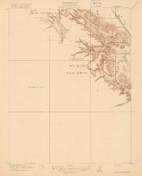
 1897 Mt. Hamilton1897 Print · USGSThe peaks and ridges of the Diablo Range are documented here in the mid-1890s, centered on the newly established Lick Observatory. Local historians can trace the early road up Mt Hamilton past the lone Hotel and remote outposts like Mowry Camp.6 unique versions available
 - 1897 Map of Concord
 1897 Concord1897 Print · USGSThe East Bay hills and valleys appear here in the late nineteenth century, just as railroads began to reshape the old rancho lands. Researchers can trace the original tracks of the California and Nevada R. R. and early settlements like Pacheco and Lafayette.6 unique versions available
 - 1897 Map of Palo Alto
 1897 Palo Alto1897 Print · USGSThe San Francisco Peninsula and Santa Clara Valley emerge in the late nineteenth century as academic and rail hubs. Trace the early footprints of Stanford University, the primary line of the Southern Pacific RR, and the transition of old ranchos like La Purisima Concepcion.
 - 1898 Map of Mt. Diablo
 1898 Mt. Diablo1898 Print · USGSContra Costa County at the end of the nineteenth century was a rugged landscape of coal mining camps and cattle valleys. Genealogists and local historians can trace the early footprints of Nortonville, Stewartville, and the remote Star Mine nestled among the peaks of Monte del Diablo.7 unique versions available
 - 1899 Map of San Jose
 1899 San Jose1899 Print · USGSThe Santa Clara Valley at the end of the century reveals a landscape of ranchos and growing rail hubs. Genealogists can trace family names and institutions from San Jose to the Santa Clara Co. Alms House and Agnew asylum.6 unique versions available
 - 1899 Map of San Francisco
 1899 San Francisco1899 Print · USGSThe Bay Area at the close of the nineteenth century reveals a burgeoning metropolis still tied to its maritime and rail roots. Trace the early layouts of the University of California and the Presidio, or locate the now-vanished Lone Mt. Cem. and Shell Mound.7 unique versions available
 - 1899 Map of Palo Alto
 1899 Palo Alto1899 Print · USGSThe San Francisco Peninsula was entering a period of rapid development in the 1890s as railroad towns began to flourish around the new Stanford University campus. You can trace early property lines across Pastoria de las Borregas or locate nineteenth-century landings like Cooley Landing and Jagel Landing.11 unique versions available
 - 1899 Map of Haywards
 1899 Haywards1899 Print · USGSThe East Bay shoreline at the end of the century was a landscape of industrial salt works and vital maritime landings. Genealogists and historians can trace the early rail stops at Haywards Sta. or locate family trade hubs at Mulford Landing and Jarvis Landing.5 unique versions available
 - 1899 Map of San Mateo
 1899 San Mateo1899 Print · USGSThe northern San Mateo peninsula appears here in the late nineteenth century as a landscape of early rail lines and critical water infrastructure. Trace the early development of South San Francisco, the sprawling Cemeteries of Colma, and rural schoolhouses like Hoyt School.6 unique versions available
 - 1902 Map of Santa Cruz
 1902 Santa Cruz1902 Print · USGSCoastal California at the end of the Victorian era reveals a landscape of redwood forests, early university towns, and remote Pacific outposts. Genealogists and historians can trace the early rail corridors through Boulder Creek and Felton or locate coastal landmarks like Pigeon Point and Halfmoon Bay.9 unique versions available
 - 1906 Map of Pleasanton
 1906 Pleasanton1906 Print · USGSThe Livermore and Amador Valleys are captured here at the turn of the century as they transitioned from ranch lands to thriving rail hubs. Genealogists and historians can trace family locations near Mission San Jose, the old Dougherty Post Office, and the junction at Niles.5 unique versions available
 - 1907 Map of Tesla
 1907 Tesla1907 Print · USGSThe industrial corridor of Corral Hollow comes to life in this early 1900s survey of the Alameda and San Joaquin border. Genealogists and historians can trace now-quiet locations like Tesla, Pottery, and the Sweet Springs Halfway House along the winding mountain passes.5 unique versions available
 - 1911 Map of Byron Hot Springs
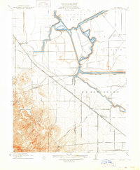
 1911 Byron Hot Springs1911 Print · USGSContra Costa County at the beginning of the twentieth century shows a landscape transitioning from ranching to railroad-driven tourism. Historians can trace the footprint of the Byron Hot Springs resort and the early rail infrastructure serving Byron.
 - 1914 Map of Bethany
 1914 Bethany1914 Print · USGSThe San Joaquin Delta was a maze of engineered waterways and rail lines just before the First World War. Researchers can trace the original routes of the Bethany Ferry and locate early landmarks like Mountain House and the Lammersville School.2 unique versions available
 - 1915 Map of San Mateo
 1915 San Mateo1915 Print · USGSThe San Francisco Peninsula at the start of the twentieth century shows a landscape transitioning from rural ranchos to industrial centers and suburbs. Genealogists can trace family footprints at Colma, locate the Hoyt School, or follow the Southern Pacific RR through Baden Sta.6 unique versions available
 - 1915 Map of Haywards
 1915 Haywards1915 Print · USGSThe East Bay shoreline and inland foothills are shown here in the mid-1910s during a height of coastal industry. Genealogists and historians can trace old shipping points like Mulford Landing, early salt operations at Union City Salt Works, and the rail lines of the Western Pacific.4 unique versions available
 - 1915 Map of Concord
 1915 Concord1915 Print · USGSContra Costa and Alameda counties are shown here just before the mid-century population boom, when the East Bay was a landscape of ranchos and rail stops. Genealogists can trace family footprints in small 1910s settlements like Moraga, Pacheco, and Lafayette.5 unique versions available
 - 1915 Map of San Francisco
 1915 San Francisco1915 Print · USGSSan Francisco and the East Bay appear at a pivotal moment just before the First World War, featuring the grand layout of the Panama-Pacific International Exposition. Genealogists and historians can trace the early rail networks of the Key Route Pier, the industrial waterfront at Winehaven, and historic landmarks like Cliff House.6 unique versions available
 - 1916 Map of Byron Hot Springs
 1916 Byron Hot Springs1916 Print · USGSEastern Contra Costa County was a landscape of historic land grants and early rail travel in the years before the Great War. Researchers can trace the original Southern Pacific route serving Byron and the specialized resort grounds of Byron Hot Springs.2 unique versions available
Showing maps 1-25 of 269
Top cities of Alameda County
- Oakland historical maps
- Fremont historical maps
- Hayward historical maps
- Berkeley historical maps
- San Leandro historical maps
- Livermore historical maps
See more
Frequently asked questions
- What are the different types of historical maps available for Alameda County?
- What is the oldest map of Alameda County?
- Where can I purchase historical maps of Alameda County for my home or office?
- Where can I download high-res historical maps of Alameda County?
- Are there historical topographic maps available for Alameda County?
- Is there historical aerial imagery available for Alameda County?
- Where are historical maps of Alameda County sourced from?