1950s Maps of Alameda County, California
Explore 38 historic maps of Alameda County from the 1950s. These maps offer a rare glimpse into what life looked like during the 1950s — showing old roads, neighborhoods, homes, and landmarks that have changed or disappeared over time.
Whether you're researching your family's past, planning a metal detecting trip, or studying how Alameda County's landscape evolved across the 1950s, these high-resolution maps are a powerful tool for exploring the history of this region.
- Focus on a specific era: All maps on this page are from the 1950s, giving you a focused view of this time period.
- See what’s changed: Compare century-old streets, trails, and buildings to today's modern landscape using overlays and satellite layers.
- Research with precision: Use these maps for genealogy, historical research, land use analysis, or educational projects.
- View, download, or print: Maps are fully viewable online in high resolution, and can be downloaded or printed for your own records.
Start exploring Alameda County's history through authentic maps from the 1950s. This is your window into the past.
Alameda County, CA maps
(38)- 1950 Map of Hayward
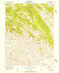
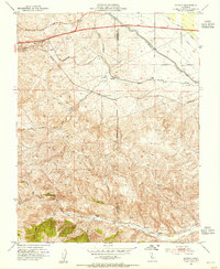
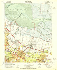
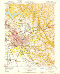 1950 Hayward1950 Print · USGSHayward and the East Bay hills are captured during the postwar building boom. Genealogists and local historians can trace old family sites and institutions like the Holy Sepulchre Cemetery, Mt Eden, and the historic Oakland Speedway.
 - 1952 Map of Bethany, 1955 Print
 1952 Bethany1955 Print · USGSThe San Joaquin Delta underwent a massive transformation in the early fifties as new water infrastructure met old agricultural tracts. Genealogists and researchers can trace local landmarks like Mountain House Sch, the Livermore Yacht Club, and the tracks of the Southern Pacific.6 unique versions available
 - 1953 Map of Diablo, 1954 Print
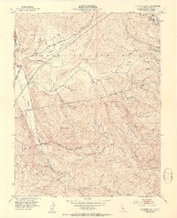
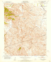
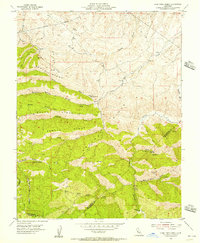
 1953 Diablo1954 Print · USGSThe East Bay's inland valleys and foothills are captured here in the early fifties, just as the ranching era met suburban growth. Genealogists and local historians can locate early landmarks like Green Valley School, the San Ramon Siding, and the expansive Black Hawk Ranch.9 unique versions available
 - 1953 Map of La Costa Valley, 1954 Print
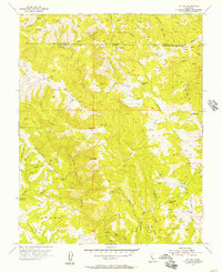
 1953 La Costa Valley1954 Print · USGSCoastal range ridges and interior valleys of Alameda County are captured here in the mid-fifties. Researchers can trace the path of the Hetch Hetchy Aqueduct and locate local landmarks like Scotts Corner and the Arroyo Del Valle Sanatorium.3 unique versions available
 - 1953 Map of Tassajara, 1954 Print
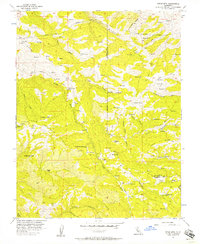
 1953 Tassajara1954 Print · USGSThe foothills of Contra Costa and Alameda counties are captured here in the early 1950s, revealing a landscape of historic land grants and canyon ranching. Genealogists and local historians can trace the foundations of the area at Tassajara and locate the former sites of the Tassajara Sch and Highland Sch.4 unique versions available
 - 1953 Map of Livermore, 1954 Print
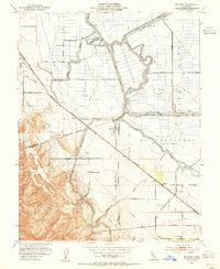
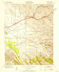
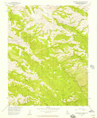
 1953 Livermore1954 Print · USGSThe Livermore Valley was a landscape of military bases and rail-hubs in the early fifties. Genealogists and historians can trace the foundations of Livermore and Pleasanton near landmarks like the Livermore Sanitarium, Dow Airport, and St Michaels Cemetery.2 unique versions available
 - 1953 Map of Altamont, 1954 Print
 1953 Altamont1954 Print · USGSThe eastern Livermore Valley transitioned into a major transit hub during the early fifties, where massive rail lines met the steep grades of the Diablo Range. Local historians can trace early community sites like Summit Sch and the Abandoned Airfield near the settlement of Altamont.10 unique versions available
 - 1953 Map of Byron Hot Springs, 1954 Print
 1953 Byron Hot Springs1954 Print · USGSThe foothills of eastern Contra Costa County are shown in the early fifties as the region balanced ranching with early industrial development. Trace the local rail-and-water economy through the Southern Pacific line, the Irrigation Canal, and the iconic Byron Hot Springs site.5 unique versions available
 - 1953 Map of Midway, 1955 Print
 1953 Midway1955 Print · USGSAltamont Pass and the Diablo Range are captured here during a period of major infrastructure growth in the early fifties. Genealogists and industrial historians can trace the foundations of former boomtowns like Tesla (Site) and Carnegie (Site) alongside the massive Delta-Mendota Canal.6 unique versions available
 - 1953 Map of Dublin, 1955 Print
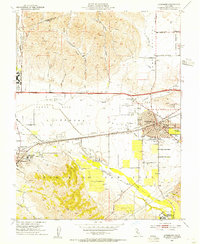
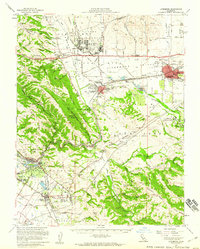
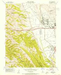 1953 Dublin1955 Print · USGSThe Amador and San Ramon Valleys are captured here during the post-war era, as military installations and suburban pockets began to transform the ranchlands. Local historians can trace the foundations of Parks Air Force Base, the Old Hearst Ranch, and the early layout of Pleasanton.2 unique versions available
 - 1953 Map of Calaveras Reservoir, 1955 Print
 1953 Calaveras Reservoir1955 Print · USGSThe foothills of the Diablo Range meet the growing Santa Clara Valley in the early fifties, showing the region before modern development. Genealogists can trace family lands in Berryessa or locate rural landmarks like the Air Point Sch and the San Jose Country Club.2 unique versions available
 - 1953 Map of Milpitas, 1955 Print
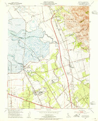 1953 Milpitas1955 Print · USGSThe South Bay marshlands and emerging suburban corridors of the early fifties are captured here before major development took hold. Researchers can trace the layout of Agnew State Hospital, the isolated rail stop at Drawbridge, and the historic Mission Santa Clara de Asis site.
 - 1953 Map of Mountain View, 1955 Print
 1953 Mountain View1955 Print · USGSThe South Bay shoreline and Peninsula communities are captured in the early fifties during a period of massive post-war growth. Researchers can trace the development of Mountain View and the expansive Moffett Field Naval Air Station alongside local landmarks like Castro City and Cooley Landing.2 unique versions available
 - 1953 Map of Niles, 1955 Print
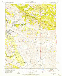
 1953 Niles1955 Print · USGSCoastal foothills and rail towns define this East Bay landscape in the early fifties, before the surge of suburban development. Researchers can trace the layout of Mission San Jose, locate the Centerville Airport, and find early landmarks like the Water Temple or Ohlones Cemetery.
 - 1953 Map of San Jose, 1959 Print
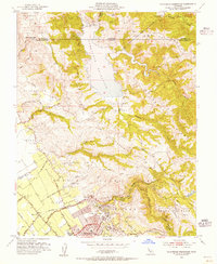
 1953 San Jose1959 Print · USGSThe Santa Clara Valley comes alive in the mid-1950s, showing the transition from agricultural ranch lands to a growing suburban and industrial hub. Researchers can trace ancestral locations near Agnew State Hospital, the original village of Alviso, or the early campus of San Jose State College.
 - 1953 Map of Livermore, 1960 Print
 1953 Livermore1960 Print · USGSThe East Bay valleys are shown during a period of significant growth and military activity in the early fifties. Researchers can trace historic family locations at Mission San Jose and local landmarks like the Water Temple or the Old Hearst Ranch.
 - 1955 Map of San Francisco
 1955 San Francisco1955 Print · USGSThe San Francisco Bay Area and central coast are captured during the postwar boom as suburbs and infrastructure expanded rapidly. Trace the development of local communities and military installations like the Presidio and Fort Mason, or follow the Southern Pacific rail lines.
 - 1955 Map of Lone Tree Creek, 1956 Print
 1955 Lone Tree Creek1956 Print · USGSThe high country where San Joaquin, Alameda, and Stanislaus counties meet is captured here in the mid-fifties. Researchers can locate early industrial sites like the Buckeye Mines and Ladd Mine or trace the route of the Hetch Hetchy Aqueduct.5 unique versions available
 - 1955 Map of Mt. Boardman, 1957 Print
 1955 Mt. Boardman1957 Print · USGSThe Diablo Range heights meet at the four-county junction of Stanislaus and Santa Clara in the mid-1950s. Researchers can trace the rugged footprint of Western Mines, the Harney School, and a Naval Bombing Range in this canyon-carved landscape.3 unique versions available
 - 1955 Map of Eylar Mountain, 1957 Print
 1955 Eylar Mountain1957 Print · USGSThe Diablo Range backcountry comes into focus in the mid-1950s, showing a rugged landscape of ridges and seasonal camps along the Alameda and Santa Clara county line. Researchers can trace remote sites like Coffey Mill, Hays Camp, and mining Tunnels near Camp Bessie.6 unique versions available
 - 1955 Map of Mt. Day, 1957 Print
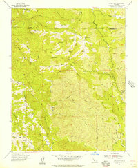
 1955 Mt. Day1957 Print · USGSThe Diablo Range highlands are shown in the mid-1950s, a period when this part of the California coast range remained largely primitive and inaccessible. Genealogists and hikers can trace remote landmarks like Van Horn Flats, Old Camp, and the waters of Arroyo Honda.4 unique versions available
 - 1956 Map of San Jose
 1956 San Jose1956 Print · USGSCentral California in the mid-fifties reveals the transition from sprawling orchards to growing urban hubs like San Jose and Stockton. Genealogists and historians can trace the rail-era landscape of the Mother Lode through Chinese Camp and Tuttletown, or follow the water through the Joaquin River and Calaveras Reservoir.
 - 1956 Map of San Francisco
 1956 San Francisco1956 Print · USGSThe San Francisco Bay Area is captured in the mid-fifties, showing a landscape of rapid post-war growth and massive military installations. Researchers can trace the sprawling rail lines of the Southern Pacific and locate historic sites like Stanford University or the Hunters Point Naval Shipyard.4 unique versions available
 - 1956 Map of Cedar Mtn, 1957 Print
 1956 Cedar Mtn1957 Print · USGSThe Alameda and San Joaquin county line runs through this high-country landscape during the mid-fifties, dominated by deep canyons and prominent ridges. Genealogists and hikers can trace the Hetch Hetchy Aqueduct and locate old landmarks like Fourteenmile House and Rancho Los Mochos.6 unique versions available
 - 1956 Map of Mendenhall Springs, 1957 Print
 1956 Mendenhall Springs1957 Print · USGSThe Alameda County highlands are captured here in the mid-1950s, showing the critical infrastructure of the Hetch Hetchy Aqueduct. Genealogists and historians can trace old homesteads and landmarks like Mendenhall Springs, Rose Flat, and the remote Shafer Flat.5 unique versions available
Showing maps 1-25 of 38
Top cities of Alameda County
- Oakland historical maps
- Fremont historical maps
- Hayward historical maps
- Berkeley historical maps
- San Leandro historical maps
- Livermore historical maps
See more
Frequently asked questions
- What are the different types of historical maps available for Alameda County?
- What is the oldest map of Alameda County?
- Where can I purchase historical maps of Alameda County for my home or office?
- Where can I download high-res historical maps of Alameda County?
- Are there historical topographic maps available for Alameda County?
- Is there historical aerial imagery available for Alameda County?
- Where are historical maps of Alameda County sourced from?