1910s Maps of Oroville, California
Explore 3 historic maps of Oroville from the 1910s. These maps offer a rare glimpse into what life looked like during the 1910s — showing old roads, neighborhoods, homes, and landmarks that have changed or disappeared over time.
Whether you're researching your family's past, planning a metal detecting trip, or studying how Oroville's landscape evolved across the 1910s, these high-resolution maps are a powerful tool for exploring the history of this region.
- Focus on a specific era: All maps on this page are from the 1910s, giving you a focused view of this time period.
- See what’s changed: Compare century-old streets, trails, and buildings to today's modern landscape using overlays and satellite layers.
- Research with precision: Use these maps for genealogy, historical research, land use analysis, or educational projects.
- View, download, or print: Maps are fully viewable online in high resolution, and can be downloaded or printed for your own records.
Start exploring Oroville's history through authentic maps from the 1910s. This is your window into the past.
Oroville, CA maps
(3)- 1912 Map of Oroville
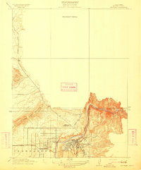 1912 Oroville1912 Print · USGSButte County's gold-mining heartland is shown here in the early twentieth century as it transitioned into a rail-and-agriculture hub. Genealogists can locate family landmarks like the Odd Fellows Home, the Butte County Infirmary, and early settlements such as Thermalito and Thompson Flat.2 unique versions available
 - 1912 Map of Palermo
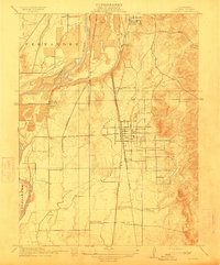 1912 Palermo1912 Print · USGSButte County agriculture and industry are in full swing at the start of the century as two major railroads compete for transit. Genealogists and historians can locate the Chinese Cem near South Oroville or trace family sites near Union School and Palermo.2 unique versions available
 - 1912 Map of Biggs
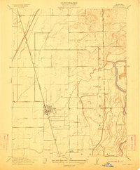 1912 Biggs1912 Print · USGSButte County agriculture was in full bloom at the start of the century, shaped by an intricate system of canals and competing rail lines. Researchers can trace family sites like Ord Ranch and Richland or find the early footprint of the River District School.
End of results
Showing maps 1-3 of 3
Top cities near Oroville
- Chico historical maps
- Live Oak historical maps
- Gridley historical maps
- Durham historical maps
- Biggs historical maps
Frequently asked questions
- What are the different types of historical maps available for Oroville?
- What is the oldest map of Oroville?
- Where can I purchase historical maps of Oroville for my home or office?
- Where can I download high-res historical maps of Oroville?
- Are there historical topographic maps available for Oroville?
- Is there historical aerial imagery available for Oroville?
- Where are historical maps of Oroville sourced from?