1970s Maps of Oroville, California
Explore 3 historic maps of Oroville from the 1970s. These maps offer a rare glimpse into what life looked like during the 1970s — showing old roads, neighborhoods, homes, and landmarks that have changed or disappeared over time.
Whether you're researching your family's past, planning a metal detecting trip, or studying how Oroville's landscape evolved across the 1970s, these high-resolution maps are a powerful tool for exploring the history of this region.
- Focus on a specific era: All maps on this page are from the 1970s, giving you a focused view of this time period.
- See what’s changed: Compare century-old streets, trails, and buildings to today's modern landscape using overlays and satellite layers.
- Research with precision: Use these maps for genealogy, historical research, land use analysis, or educational projects.
- View, download, or print: Maps are fully viewable online in high resolution, and can be downloaded or printed for your own records.
Start exploring Oroville's history through authentic maps from the 1970s. This is your window into the past.
Oroville, CA maps
(3)- 1970 Map of Biggs, 1973 Print
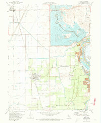 1970 Biggs1973 Print · USGSButte County agriculture is at its height in the early 1970s as massive irrigation projects reshape the Sacramento Valley. Researchers can trace family-named roads and landmarks like the Gridley-Biggs Cemetery, the USDA Rice Experimental Sta, and the shoreline of the Thermalito Afterbay.2 unique versions available
 - 1970 Map of Oroville, 1973 Print
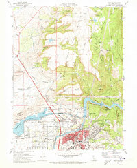 1970 Oroville1973 Print · USGSThe Gold Country meets modern hydro-engineering in Butte County during the early seventies. Trace the evolution of Oroville from its mining roots at Oregon City to the complex water systems of the Thermalito Afterbay and Lake Oroville.2 unique versions available
 - 1970 Map of Palermo, 1973 Print
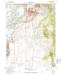 1970 Palermo1973 Print · USGSButte County saw significant industrial and residential shifts in the early seventies as mining landscapes met expanding suburbs. You can trace the path of the Western Pacific Railroad or locate local landmarks like Lone Tree School and the Oroville Cem.3 unique versions available
End of results
Showing maps 1-3 of 3
Top cities near Oroville
- Chico historical maps
- Live Oak historical maps
- Gridley historical maps
- Durham historical maps
- Biggs historical maps
Frequently asked questions
- What are the different types of historical maps available for Oroville?
- What is the oldest map of Oroville?
- Where can I purchase historical maps of Oroville for my home or office?
- Where can I download high-res historical maps of Oroville?
- Are there historical topographic maps available for Oroville?
- Is there historical aerial imagery available for Oroville?
- Where are historical maps of Oroville sourced from?