Old Maps of Stegeman, California for Academic Research
Study the evolution of Stegeman with 12 high-resolution historic maps. Whether you're teaching, researching, or modeling changes in land use, these maps provide essential visual documentation of urban, environmental, and geographic change.
- Analyze long-term change: Track patterns in development, transportation, and natural features.
- Ideal for environmental or urban studies: Support academic projects with primary historical map data.
- Use in the classroom or lab: Educators and researchers rely on these maps to bring historical context to life.
These maps are a powerful tool for teaching, research, and visualizing how Stegeman has changed over the decades.
Stegeman, CA maps
(12)- 1906 Map of Maxwell
 1906 Maxwell1906 Print · USGSColusa and Glenn Counties at the dawn of the century show a landscape defined by massive land grants and new irrigation. Trace family roots and vanished river stops like Boggs Landing and Compton Landing along the Sacramento River.3 unique versions available
 - 1917 Map of Compton Landing
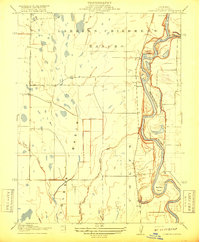 1917 Compton Landing1917 Print · USGSColusa County at the start of the twentieth century was a land of river landings and vast ranchos along the shifting Sacramento River. Researchers can trace the boundaries of the Larkins Childrens Rancho and locate historical river access points like Compton Landing and Boggs Landing.2 unique versions available
 - 1952 Map of Moulton Weir, 1953 Print
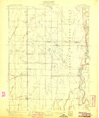
 1952 Moulton Weir1953 Print · USGSThe Sacramento Valley's agricultural and river economy comes into focus in the early fifties as irrigation and rail lines reshaped the Colusa Basin. Researchers can trace family-named sites like Stegeman and Keller Ranch or locate the Butte Creek School and Cachil Dehe Rancheria.2 unique versions available
 - 1952 Map of Maxwell, 1958 Print
 1952 Maxwell1958 Print · USGSThe Sacramento Valley comes alive in this mid-century survey of the Maxwell and Princeton areas, showcasing a landscape of river bends and rail sidings. Genealogists can trace family roots through several rural schools like Liberty Sch and Codora Sch, or locate the historic Cachil Dehe Rancheria.2 unique versions available
 - 1957 Map of Ukiah, 1966 Print
 1957 Ukiah1966 Print · USGSNorthern California's diverse terrain comes into focus in the mid-1950s, from the rugged timberlands of the Jackson State Forest to the productive Sacramento Valley. Genealogists and historians can trace the rail lines of the Northwestern Pacific or locate early valley settlements like Arbuckle and Paskenta.3 unique versions available
 - 1960 Map of Ukiah
 1960 Ukiah1960 Print · USGSNorthern California during the late fifties reveals a landscape of deep timber forests and valley agriculture before modern expansion. Trace the historic rail lines of the California Western RR and the Northwestern Pacific RR through settlements like Fort Bragg and Ukiah.2 unique versions available
 - 1991 Map of Moulton Weir, 1995 Print
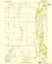
 1991 Moulton Weir1995 Print · USGSThe Sacramento Valley in the early nineties is revealed here as a landscape of irrigation canals, river bends, and vast wildlife preserves. Researchers can trace local history through the Colusa (Cachil Dehe) Rancheria, the Butte Creek School, and the Keller Ranch.
 - 1994 Map of Lakeport
 1994 Lakeport1994 Print · USGSCoastal mountains meet the fertile Sacramento Valley in the 1990s, where the waters of Clear Lake define the western landscape. Researchers can trace the industrial footprint of the Sulphur Bank Mine, follow the Southern Pacific RR tracks, or locate old settlements like Fouts Springs and Lodoga.
 - 2012 Map of Moulton Weir, 2012 Print
 2012 Moulton Weir2012 Print · USGSCovers Stegeman, including Colusa Rancheria, Colusa County, and other nearby areas
 - 2015 Map of Moulton Weir, 2015 Print
 2015 Moulton Weir2015 Print · USGSCovers Stegeman, including Colusa Rancheria, Colusa County, and other nearby areas
 - 2018 Map of Moulton Weir, 2018 Print
 2018 Moulton Weir2018 Print · USGSCovers Stegeman, including Colusa Rancheria, Colusa County, and other nearby areas
 - 2021 Map of Moulton Weir, 2021 Print
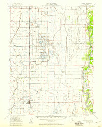
 2021 Moulton Weir2021 Print · USGSThe Sacramento River valley in Colusa County reveals a landscape of complex water management and river-bend settlements in the early twenty-first century. Genealogists and researchers can trace local landmarks like Stegeman, the sweeping curve of Hamilton Bend, and the industrial-agricultural utility of the Colusa Trough.
End of results
Showing maps 1-12 of 12
Top cities near Stegeman
- Willows historical maps
- Colusa historical maps
- Durham historical maps
- Williams historical maps
- Maxwell historical maps
- Butte City historical maps
Frequently asked questions
- What are the different types of historical maps available for Stegeman?
- What is the oldest map of Stegeman?
- Where can I purchase historical maps of Stegeman for my home or office?
- Where can I download high-res historical maps of Stegeman?
- Are there historical topographic maps available for Stegeman?
- Is there historical aerial imagery available for Stegeman?
- Where are historical maps of Stegeman sourced from?