1960s Maps of El Dorado County, California
Explore 5 historic maps of El Dorado County from the 1960s. These maps offer a rare glimpse into what life looked like during the 1960s — showing old roads, neighborhoods, homes, and landmarks that have changed or disappeared over time.
Whether you're researching your family's past, planning a metal detecting trip, or studying how El Dorado County's landscape evolved across the 1960s, these high-resolution maps are a powerful tool for exploring the history of this region.
- Focus on a specific era: All maps on this page are from the 1960s, giving you a focused view of this time period.
- See what’s changed: Compare century-old streets, trails, and buildings to today's modern landscape using overlays and satellite layers.
- Research with precision: Use these maps for genealogy, historical research, land use analysis, or educational projects.
- View, download, or print: Maps are fully viewable online in high resolution, and can be downloaded or printed for your own records.
Start exploring El Dorado County's history through authentic maps from the 1960s. This is your window into the past.
El Dorado County, CA maps
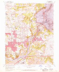
(5)- 1960 Map of Chico
 1960 Chico1960 Print · USGSThe Northern California high country and Sacramento Valley meet in this 1960s-era landscape of mining towns and river settlements. Trace the rail-and-water economy of the gold country through the Empire Mine, Beale Air Force Base, and the Western Pacific Railroad.
 - 1962 Map of Walker Lake
 1962 Walker Lake1962 Print · USGSThe high desert of western Nevada and the Sierra Nevada crest meet in this mid-century study of the Eastern Sierra frontier. Researchers can trace the Southern Pacific rail lines connecting Hawthorne to remote mining outposts like Bodie, Aurora, and Mina.
 - 1964 Map of Walker Lake
 1964 Walker Lake1964 Print · USGSThe high desert and the Sierra Nevada peaks come together in the mid-1960s, showing a landscape defined by mining, military installations, and vast wilderness. Genealogists and historians can trace the remnants of old mining camps at Bodie or Candelaria and follow the Southern Pacific rail lines.2 unique versions available
 - 1967 Map of Folsom, 1968 Print
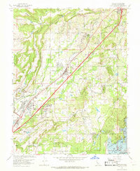
 1967 Folsom1968 Print · USGSThe American River corridor was undergoing rapid transformation in the late sixties as suburban growth met industrial history. Researchers can locate Folsom State Prison, trace the old Prairie City (Site), and see the extensive Dredge Tailings left from gold mining days.4 unique versions available
 - 1967 Map of Rocklin, 1968 Print
 1967 Rocklin1968 Print · USGSPlacer County's foothill corridor underwent significant transition in the late sixties as traditional rail towns met new suburban growth. Genealogists and historians can trace family-named landmarks like Stallman Corners or locate Placer Ch and the Mary Leh Mine.3 unique versions available
End of results
Showing maps 1-5 of 5
Top cities of El Dorado County
- El Dorado Hills historical maps
- South Lake Tahoe historical maps
- Cameron Park historical maps
- Placerville historical maps
- Pollock Pines historical maps
- Diamond Springs historical maps
See more
Frequently asked questions
- What are the different types of historical maps available for El Dorado County?
- What is the oldest map of El Dorado County?
- Where can I purchase historical maps of El Dorado County for my home or office?
- Where can I download high-res historical maps of El Dorado County?
- Are there historical topographic maps available for El Dorado County?
- Is there historical aerial imagery available for El Dorado County?
- Where are historical maps of El Dorado County sourced from?