1950s Maps of El Dorado County, California
Explore 59 historic maps of El Dorado County from the 1950s. These maps offer a rare glimpse into what life looked like during the 1950s — showing old roads, neighborhoods, homes, and landmarks that have changed or disappeared over time.
Whether you're researching your family's past, planning a metal detecting trip, or studying how El Dorado County's landscape evolved across the 1950s, these high-resolution maps are a powerful tool for exploring the history of this region.
- Focus on a specific era: All maps on this page are from the 1950s, giving you a focused view of this time period.
- See what’s changed: Compare century-old streets, trails, and buildings to today's modern landscape using overlays and satellite layers.
- Research with precision: Use these maps for genealogy, historical research, land use analysis, or educational projects.
- View, download, or print: Maps are fully viewable online in high resolution, and can be downloaded or printed for your own records.
Start exploring El Dorado County's history through authentic maps from the 1950s. This is your window into the past.
El Dorado County, CA maps
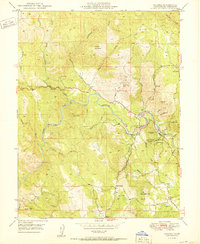
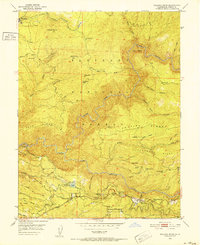
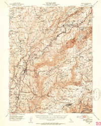
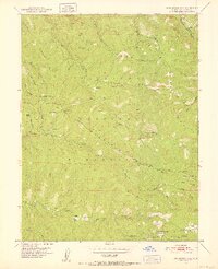
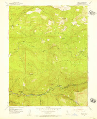
(59)- 1950 Map of Placerville
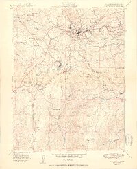 1950 Placerville1950 Print · USGSEl Dorado County in the late 1940s retains the clear footprint of its mining and railroad heritage. Researchers can trace the location of vanished settlements at Logtown (Site) and Cold Springs (Site), alongside active landmarks like the Crusader Mine and the Southern Pacific line.2 unique versions available
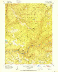
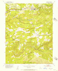
 - 1950 Map of Greenwood
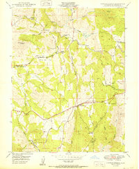
 1950 Greenwood1950 Print · USGSThe California Gold Country near the El Dorado and Placer county line was undergoing significant change in the mid-twentieth century. Trace the legacy of mining through sites like Spanish Dry Diggings, Grit Mine, and the early reservoir development at Applegate.
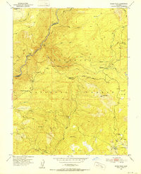
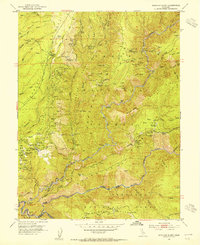
 - 1950 Map of Fiddletown
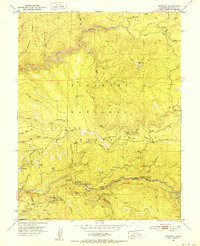
 1950 Fiddletown1950 Print · USGSMid-century Amador and El Dorado counties are captured here during a time of rural persistence in the Sierra foothills. Genealogists and historians can trace family-named sites like Bell Ranch alongside community centers like the Shenandoah Sch and the historic settlement of Fiddletown.
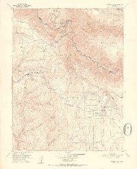
 - 1950 Map of Georgetown
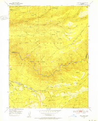
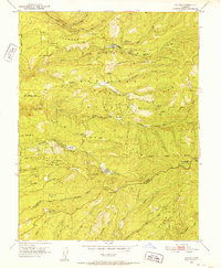
 1950 Georgetown1950 Print · USGSThe Mother Lode country north of Placerville appears here in the late 1940s, highlighting a landscape shaped by decades of mining. Researchers can trace historic sites like African Bar, find the Canyon Creek School, and locate mines such as the Josephine Mine.
 - 1950 Map of Latrobe
 1950 Latrobe1950 Print · USGSEl Dorado County ranching and mining life are captured here at mid-century, just before the modernization of the foothills. Genealogists can trace family landmarks like Miller Ranch and Brandon Corner or locate the Chinese Cem and early schoolhouses.2 unique versions available
 - 1950 Map of Coloma
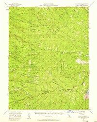
 1950 Coloma1950 Print · USGSThe Gold Rush heartland comes into focus mid-century as the historic river towns maintain their identity. Trace family roots and mining claims near the Sutters Mill (Site), the Lilyama Mine, and the Johntown Cem.
 - 1950 Map of Shingle Springs
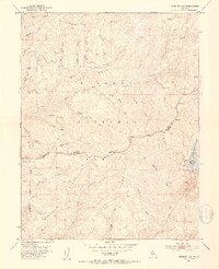
 1950 Shingle Springs1950 Print · USGSEl Dorado County foothills in the post-war era reveal a landscape of gold-mining roots and rural schools. Genealogists and historians can trace family-named locations such as Jayhawk Cem, the settlement of Rescue, and industrial sites like Greenstone Mine.
 - 1950 Map of Garden Valley
 1950 Garden Valley1950 Print · USGSEl Dorado County gold country is captured here in the mid-century, before modern development reshaped these historic ridges and canyons. Researchers can trace the legacy of mining and early industry at sites like the Alhambra Mine, Slate Mine, and the Rock Creek Powerhouse.
 - 1950 Map of Riverton, 1952 Print
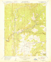
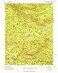
 1950 Riverton1952 Print · USGSEl Dorado County mountain life in the early fifties was centered on the river canyons and timber ridges. Researchers can locate remote family landmarks like the McConnel Place, the Big Bend Sch, and historical sites along the South Fork American River.6 unique versions available
 - 1950 Map of Devil Peak, 1952 Print
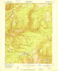
 1950 Devil Peak1952 Print · USGSThe deep canyons of the Sierra Nevada are surveyed here at mid-century as the gold-mining era gives way to forest management. You can trace early industrial footprints including the Dismantled Railroad and several inactive sites like the Clydesdale Mine and Pigeon Roost Mine.7 unique versions available
 - 1950 Map of Pollock Pines, 1952 Print
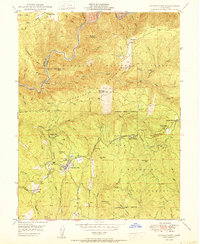
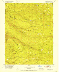
 1950 Pollock Pines1952 Print · USGSThe timber and power landscapes of the Sierra foothills are captured here in the early fifties. Researchers can trace the Dismantled Logging RR, locate the Bullion Bend Historic Marker, and explore old sites like Pino Grande and Indian Hatties.4 unique versions available
 - 1950 Map of Slate Mtn, 1952 Print
 1950 Slate Mtn1952 Print · USGSEl Dorado County mountain life in the early fifties was centered on the timber and mining economies of the Slate Mountains. Local historians can locate specific sites like the Mosquito District Sch, Slate Mtn Mine, and the American River Intake Dam.4 unique versions available
 - 1950 Map of Robbs Peak, 1952 Print
 1950 Robbs Peak1952 Print · USGSThe high Sierra backcountry of El Dorado County is documented here at mid-century, before significant modern development altered these forest drainages. Researchers can locate remote outposts like Uncle Toms Cabin, the Robbs Peak Lookout, and the historic Georgetown Divide.6 unique versions available
 - 1950 Map of Tunnel Hill, 1952 Print
 1950 Tunnel Hill1952 Print · USGSEl Dorado County timber and mining country come to life in the early fifties as the region's resource-based economy matured. Trace family-named landmarks and old extraction sites like Barton Cabin, the Kenna Mine, and the fire lookout at Bald Mtn Lookout.7 unique versions available
 - 1950 Map of Colfax, 1953 Print
 1950 Colfax1953 Print · USGSPlacer and Nevada Counties are shown here during the early post-war years, as the Mother Lode's industrial footprint remained clearly visible. Genealogists and historians can trace the Southern Pacific line through historic sites like Illinoistown and active communities such as Foresthill and Weimar.4 unique versions available
 - 1950 Map of Saddle Mountain, 1955 Print
 1950 Saddle Mountain1955 Print · USGSEl Dorado County in the 1950s was a landscape defined by its river forks, timber camps, and deep-canyon gold mines. Genealogists and researchers can trace the locations of family-held properties like Bacchi Ranch and Morton Ranch or the remote Mosquito District School.5 unique versions available
 - 1951 Map of Foresthill
 1951 Foresthill1951 Print · USGSIn the Gold Country of the 1950s, the Sierra Nevada ridges were defined by decades of mining and the timber industry. Researchers can trace the extensive Placer Diggings and historic claims like the Baltimore Mine, Mayflower Mine, and Morning Star Mine.
 - 1951 Map of Stump Spring, 1952 Print
 1951 Stump Spring1952 Print · USGSEl Dorado County was a hub of timber and mineral extraction in the early fifties, as seen in this detailed sierra survey. Local historians can trace old resource operations like the Girard Mill Site, Robert Lee Mine, and family landmarks like Bryants.9 unique versions available
 - 1951 Map of Leek Spring Hill, 1952 Print
 1951 Leek Spring Hill1952 Print · USGSHigh Sierra forest land in the early fifties is dominated by prominent ridgelines and the headwaters of major rivers. Local historians can trace early settlements and lookouts like Pilliken, Morrison, and the fire station at Iron Mountain.3 unique versions available
 - 1951 Map of Caldor, 1952 Print
 1951 Caldor1952 Print · USGSEl Dorado County logging and mining operations are captured here at mid-century, just as the forest service infrastructure was expanding. Researchers can locate remote sites like the Arbor Mine, the Fort Grizzly Site, and settlements at Caldor and Cooks Station.5 unique versions available
 - 1951 Map of Peddler Hill, 1953 Print
 1951 Peddler Hill1953 Print · USGSThe high ridges of the El Dorado and Amador county line are captured here in the early fifties, showcasing a landscape of active timber management and emerging recreation. Researchers can locate the Lumberyard Ranger Station, trace the Caldor Logging Road, and find seasonal sites like Grellich Camp and the local Ski Lodge.5 unique versions available
 - 1951 Map of Leek Spring Hill, 1958 Print
 1951 Leek Spring Hill1958 Print · USGSThe western Sierra Nevada slopes in the early fifties reveal a landscape of active forestry and deep-rooted mining history. Researchers can trace the timber and mineral economy through locations like Girard Mill (Site), the Tiger Mine, and the settlement of Caldor.3 unique versions available
 - 1952 Map of Kyburz, 1954 Print
 1952 Kyburz1954 Print · USGSEl Dorado County mountaineering and forestry are front and center in this early 1950s survey of the High Sierra foothills. Local historians can trace the foundations of the Kyburz settlement and locate vanished remote outposts like the Windmiller Cabin, Wilson Ranch, and the Silver Fork School.4 unique versions available
 - 1952 Map of Camino, 1954 Print
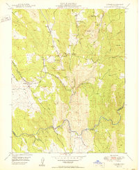
 1952 Camino1954 Print · USGSEl Dorado County’s timber and mining heritage is on full display in the early fifties, from the mills of Camino to the river crossings at Bucks Bar. Researchers can trace the path of the Camino Placerville and Lake Tahoe RR and locate the Old Fort Jim Historical Marker near early settlement sites.8 unique versions available
 - 1952 Map of Michigan Bluff, 1954 Print
 1952 Michigan Bluff1954 Print · USGSThe Placer County gold country is surveyed here during the mid-twentieth century, revealing a landscape defined by deep river canyons and hydraulic mining legacy. Genealogists and historians can trace old claims like the Golden Gate Mine, locate the Cemetery at Michigan Bluff, and find remote locations like Maintop.7 unique versions available
Showing maps 1-25 of 59
Top cities of El Dorado County
- El Dorado Hills historical maps
- South Lake Tahoe historical maps
- Cameron Park historical maps
- Placerville historical maps
- Pollock Pines historical maps
- Diamond Springs historical maps
See more
Frequently asked questions
- What are the different types of historical maps available for El Dorado County?
- What is the oldest map of El Dorado County?
- Where can I purchase historical maps of El Dorado County for my home or office?
- Where can I download high-res historical maps of El Dorado County?
- Are there historical topographic maps available for El Dorado County?
- Is there historical aerial imagery available for El Dorado County?
- Where are historical maps of El Dorado County sourced from?